Victorian Resources Online (archived)
GP15
| Location: Ellinbank Dairy Research Institute | Australian Soil Classification: Acidic, Mesotrophic, Red FERROSOL. |
| Northcote Factual Key: Gn4.11 | Great Soil Group: krasnozem. |
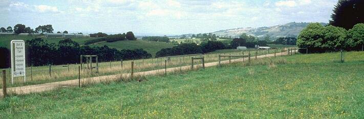
| Geology: Maturely dissected early Tertiary basalt plain. | General Landscape Description: Upper slope of rolling hill. |
| Mapping Unit: Warragul | Geographic Reference: 406034E, 5765982N |
Soil Profile Morphology:
Surface Soil
| A1 | 0-30 cm | Dark brown (7.5YR3/4); fine sandy clay loam (subplastic); weak coarse blocky, parting to strong fine blocky, parting to strong very fine polyhedral structure; weak consistence moist; contains very few (2%) manganese nodules; pH 5.3; gradual change to: | 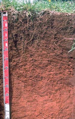 |
| Subsoil | |||
| B21 | 30-50 cm | Yellowish red (5YR4/6); clay loam (subplastic); moderate medium blocky, parting to strong fine blocky structure; weak consistence moist; pH 5.7; gradual change to: | |
| B22 | 50-80 cm | Red (2.5YR5/8); light clay (subplastic); moderate medium blocky, parting to strong fine blocky structure; contains very few (2%) soft manganese segregations; pH 5.1; gradual change to: | |
| B23 | 80-100 cm | Yellowish red (5YR5/8); light clay (subplastic); weak coarse blocky, parting to strong fine polyhedral structure; pH 4.8; clear change to: | |
| B24 | 100 cm+ | Yellowish red (5YR5/8); light clay (subplastic); moderate coarse polyhedral, parting to strong fine polyhedral structure; contains many (30%) clay/iron oxide nodules (1-2 cm size); pH 4.7. | |
Key Profile Features:
- Gradual increase in clay content with depth.
- Well structured (i.e. strong aggregation - parting into finer sizes).
- High free iron oxide content (i.e. Ferrosol).
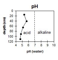 | 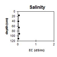 | 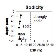 |  |
The surface soil is strongly acid. The upper subsoil is moderately acid but becomes very strongly acid with depth. | The level of soluble salts is very low throughout the profile. |
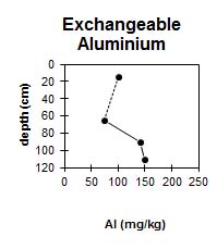
| The soil profile has a moderate level of exchangeable aluminium. |
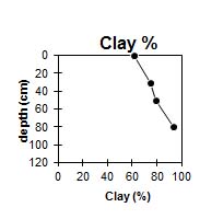 | |||
The clay percentage increases gradually with depth down the profile. |
Horizon | Horizon Depth (cm) | pH water | pH CaCl2 | EC dS/m | Exchangeable Cations | Exchangeable Aluminium mg/kg | Field Capacity pF 2.5 | Wilting Point pF 4.2 | Coarse Sand (0.2 -2.0 mm) | Fine Sand (0.02-0.2 mm) | Silt (0.002-0.02 mm) | Clay (<0.002 mm) | |||
Ca | Mg | K | Na | ||||||||||||
meq/100 g | |||||||||||||||
A1 | 0-30 | 4.6 | 5.3 | 0.06 | 5.3 | 0.94 | 0.54 | 0.25 | 100 | 38.1 | 24.5 | 2 | 12 | 17 | 61 |
B21 | 30-50 | 4.9 | 5.7 | <0.05 | 6.2 | 0.7 | 0.31 | 0.19 | 36.5 | 25.6 | 1 | 10 | 16 | 75 | |
B22 | 50-80 | 4.6 | 5.1 | 0.05 | 3.9 | 0.58 | 0.38 | 0.1 | 74 | 37.9 | 26.7 | 1 | 9 | 14 | 79 |
B23 | 80-100 | 4.4 | 4.8 | 0.07 | 2.8 | 0.63 | 0.27 | 0.07 | 140 | 42.9 | 28.3 | 1 | 10 | 1 | 94 |
B24 | 100+ | 4.3 | 4.7 | <0.05 | 1.5 | 0.52 | 0.21 | 0.07 | 150 | ||||||
Management Considerations:
Whole Profile
- Ferrosols have high levels of free iron oxide which gives them a high degree of structural stability.
- These soils are deep and very well drained due to their strongly developed structure. Water infiltration rates will be high unless significant compaction has occurred.
- Plant Available Water Capacity (PAWC) is considered to be high (estimated at approximately 160 mm) for the top metre of this soil profile. Rooting depth for a number of plants may, however, be considerably deeper on these well structured soils, resulting in higher PAWC values. A significant proportion (i.e. 60 mm) of the plant available water occurs in the surface horizon.
- Due to their high iron oxide contents these soils tend to "fix" phosphorus which makes it unavailable to plants. Regular phosphorus application will assist in overcoming such a deficiency. Addition of molybdenum may also be required. This can be assessed by plant tissue analysis of clover. Zinc and copper can also be 'fixed' by high iron oxide contents.
- Coughlan et al. (1973) noted that heavy applications of superphosphate can dissolve large amounts of iron and aluminium from the soil and may result in reduced aggregation.
- Soil compaction from trafficking can lead to reduced water infiltration and retention as well as an increase in soil strength (resulting in mechanical resistance to roots) and cloddiness. Compaction of these clayey soils can be caused by over-cultivation or trafficking, particularly when the soil is wetter than the plastic limit. Ideally, tillage and trafficking should occur when the soil is drier than the plastic limit (at least down to the depth of cultivation). Compaction on soils such as these can be more serious than on cracking clay soils which tend to self-repair due to their strong shrink-swell capacity.
- A study by Hirst et al. (1992) of Ferrosols in the Thorpdale area found that wheel traffic has a considerable effect on soil strength (as measured by penetrometer resistance) at the beginning of the growing season. Non-ripped and re-trafficked furrows were significantly more compacted to a depth of 30 cm than un-trafficked or ripped furrows. This compaction resulted in reduced water infiltration (and therefore greater runoff). This has important implications for runoff and soil erosion, particularly early in the growing season when crop cover is minimal and the probability of intense storms is high. Over the course of the growing season, soil strength decreased in compacted furrows. In terms of management, it is recommended that wheel traffic be minimised (especially if the soil is wetter than the plastic limit) to prevent soil compaction. Wheel tracks and other compacted areas can be deep ripped (when dry) or cultivated across the slope to promote infiltration and minimise the potential for runoff.
- When cultivated in a too moist condition, such soils can be prone to form large clods, which can create difficulties when harvesting potatoes. A decline in organic matter levels may also contribute to clod development.
- Red Ferrosols (krasnozems) have a high pH buffering capacity (i.e. require a larger lime application to raise soil pH). Over-liming, however, may result in some micronutrient deficiencies and may result in reduced aggregate stability.
- This soil has a reasonably high organic matter content. Red Ferrosols generally have high organic matter levels, which enhance soil fertility and aggregate stability. When intensively cropped, organic matter levels will decline and this will result in some structural degradation and fertility decline. Studies have shown that organic matter is an important source of nitrogen, phosphorus and sulphur in such soils. Organic matter levels can be improved by utilising green manure crops, crop residue retention, minimal cultivation and pasture rotations.
- Management practices which result in increased organic matter levels include: minimum tillage; growing green manure crops (e.g. annual ryegrass, sorghum, oats, lupins); incorporating pasture phases in crop rotations, and retaining and incorporating crop residues (Cotching 1995).
- The level of exchangeable aluminium is moderate in the strongly acid surface horizon. This is only likely to restrict the growth of highly aluminium sensitive species.
- The nutrient status (based on the sum of the exchangeable basic cations) of these strongly leached soils is not high (particularly below the surface horizon). Fertiliser input is often needed if intensive cropping is to take place. Organic matter is a major source of cation exchange in such soils.
- The high wilting point value (i.e. 25%) indicates that plants will not be able to utilise light rains falling on relatively dry soil. Plant available water capacity is, however, quite high for the surface soil.
- The subplastic properties of the subsoil can lead to problems with sealing of earth dams. Sealing of dams constructed on such soils can be achieved by compaction at the optimum water content and treatment with sodium tri-polyphosphate or addition of bentonite (Rolfe 1989).
- Exchangeable aluminium levels will be low in the moderately acid upper subsoil. As pH decreases in the deeper subsoil, then exchangeable aluminium levels increase. These levels are only likely to affect the growth of deeper-rooted highly aluminium sensitive species.
Note: For an excellent review paper on management of Ferrosols refer to Cotching (1995). Also, the results of a study of land management effects on the structure of Ferrosols in this region has been presented by Hirst et al. (1992).