Victorian Resources Online (archived)
GP19
| Location: Darnum. | Australian Soil Classification: Bleached, Kandosolic, Redoxic HYDROSOL |
| Northcote Factual Key: Um 2.21 | Great Soil Group: podzolic |
| Geology: Recent alluvial fan and alluvial plain deposits (derived from Strzelecki's). | General Landscape Description: Level Plain. |
| Mapping Unit: Yarragon | |
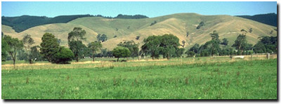 Site GP19 Landscape |
Soil Profile Morphology:
Surface Soil
| A1 | 0-20 cm | Greyish brown (10YR5/2); silty clay loam; weak blocky structure; firm consistence moist; pH 5.2; clear change to: | 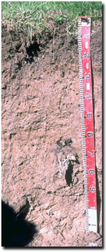 Site GP19 Profile |
| A2 | 20-35 cm | Pale brown (10YR6/3) with slight yellowish brown (10YR5/6) mottles; silty clay loam; weak blocky structure; firm consistence dry; contains a few (2-5%) ferromanganiferous nodules (and dark stains (8 mm size); pH 5.8; clear change to: | |
| Subsoil | |||
| B21 | 35-90 cm | Pale brown (10YR6/3) with dark brown (7.5YR3/4) mottles; silty clay loam; weak blocky structure; very firm consistence dry; pH 5.9; clear change to: | |
| B22 | 90+ cm | Pale brown (10YR6/3) with yellowish brown (10YR5/6) mottles; silty clay; pH 5.6. | |
Key Profile Features:
- Lack of texture contrast between surface (A) horizons and weakly structured subsoil (B) horizons (i.e. Kandosolic).
- The soil profile is saturated for prolonged periods (i.e. several months) in most years (i.e. Hydrosol).
Soil Profile Characteristics:
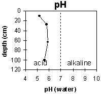 | 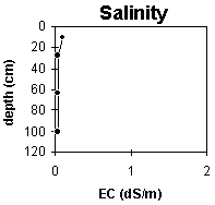 | 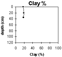 | |
The surface horizon is strongly acid. The soil profile then becomes moderately acid throughout. | The salinity rating is very low throughout the profile. | The clay content remains uniform throughout most of the soil profile |
Horizon | Horizon Depth (cm) | pH water | pH CaCl2 | EC 1:5 | Exchangeable Cations | Ex. Al mg/kg | Field Capacity pF 2.5 | Wilting Point pF 4.2 | Coarse Sand (0.2 -2.0 mm) | Fine Sand (0.02-0.2 mm) | Silt (0.002-0.02 mm) | Clay (<0.002 mm) | |||
Ca | Mg | K | Na | ||||||||||||
meq/100g | |||||||||||||||
A1 | 0-20 | 4.5 | 5.2 | 0.09 | 3 | 1.1 | 0.28 | 0.28 | 46 | 40.1 | 10.9 | 1 | 38 | 46 | 18 |
A2 | 20-35 | 4.7 | 5.8 | <0.05 | 2.8 | 1.2 | 0.12 | 0.16 | 30.1 | 7 | 1 | 39 | 45 | 19 | |
B21 | 35-90 | 4.9 | 5.9 | <0.05 | 2.6 | 1.5 | 0.13 | 0.18 | 28.4 | 6.9 | 1 | 36 | 47 | 19 | |
B22 | 90+ | 4.5 | 5.6 | <0.05 | 2 | 1.5 | 0.13 | 0.27 | |||||||
Management Considerations:
Whole Profile
- Plant available water capacity is considered to be low (estimated at 70 mm) for the top metre of the soil profile. This is based on available laboratory data.
- The soil profile is likely to be saturated for prolonged periods (i.e. several months) in most years.
- The surface soil has a low inherent nutrient status (based on the sum of the basic exchangeable cations).
- Aluminium toxicity can occur in strongly acid surface soils. The level of exchangeable aluminium measured in the laboratory (i.e. 46 ug/g) is, however, not high for this particular site. Manganese toxicity can also occur in strongly acid soils, particularly if waterlogging occurs. These measurements are best made using a bulked sample taken from across a paddock.
- Molybdenum deficiency can also occur in acid soils. Increasing pH by liming will increase molybdenum availability.
- Deterioration in surface soil structure is likely to occur (i.e. pugging, compaction) if overstocking takes place when the soil is wet.
- The subsoil has a low nutrient status (based on the sum of the basic exchangeable cations).