Victorian Resources Online (archived)
Monomeith, sandy loam surfaces (Mn,sl)
Two areas of the Monomeith sandy loam surface mapping unit occur about 4 km east and about 7 km south of Lang Lang. As well as soils described under the Monomeith mapping unit, much of the alluvial plain has a dark brownish grey, fine sandy loam surface soil rather than the usual clay loam to light clay surface.
These areas are traversed by old and defunct meandering stream courses generally with low levees which have lighter textured (i.e. less clayey and sandier) surface soils. These variations in surface texture show up as different tones on aerial photographs.
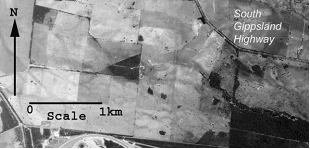
Source: Aerial photo Melbourne Eastern Suburbs Run 5 (2385-177). Victorian State Aerial Survey (January 1970).