Victorian Resources Online (archived)
GP66
| Location: Nambrok. | Australian Soil Classification: Vertic, Mottled-Subnatric,Brown SODOSOL |
| Great Soil Group: solodic | Geology: Late Quaternary prior stream deposits. |
| General Landscape Description: Level plain with prior stream activity. | Mapping Unit: Denison [This soil is equivalent to Nambrok clay loam as described by Skene and Walbran (1948)]. |
| Site Description: Uncultivated area beside dairy grazing paddock. | |
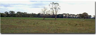 Site GP66 Landscape |
Soil Profile Morphology:
Surface Soil
| A1 | 0-10 cm | Brown (10YR4/3); silty clay loam; weak coarse blocky structure; very firm consistence, moist; many macropores; pH 5.4; clear change to: | 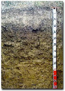 Site GP66 Soil Profile |
| A2 | 10-20 cm | Brown (10YR5/3), conspicuously bleached (10YR7/3d); some rusty root channel mottling; clay loam; moderate coarse polyhedral structure; very firm consistence moist; pH 5.7; clear change to: | |
| Subsoil | |||
| B21 | 20-35 cm | Dark brown (10YR3/3) with yellowish brown (10YR5/6) mottles; medium clay; moderate coarse prismatic, parting to strong coarse polyhedral structure; contains a few (5%) iron nodules (2-4 mm in size); pH 6.0; clear change to: | |
| B22 | 35-50 cm | Dark brown (10YR4/3) with (40%) brownish yellow (10YR6/8) mottles; heavy clay; moderate coarse prismatic, parting to moderate coarse blocky structure; slickensides present; pH 7.0; gradual change: | |
| B23 | 50-90 cm | Light olive brown (2.5Y5/4); heavy clay; strong coarse prismatic, parting to moderate coarse blocky structure; slickensides present; pH 8.1: | |
| B24 | 90+ cm | Light olive brown (2.5Y5/6); heavy clay; pH 8.9. | |
Key Profile Features:
| |
| Soil Profile Characteristics: | |
pH | Salinity Rating | |||
Surface (A1 Horizon) | Strongly Acid | Low - Moderate | Non-Sodic | None1 |
Subsoil (B21 Horizon) | Moderately Acid | Low | Sodic | Slight2 |
Deeper Subsoil (at 90cm) | Strongly Alkaline | Low | Strongly Sodic | Slight2 |
2 Complete dispersion after remoulding.
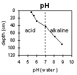 | The soil profile becomes increasingly alkaline with depth. | 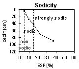 | The surface soil is non-sodic. The sub-soil is sodic, becoming strongly sodic at 80 cm. |
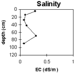 | The surface salinity levels are low to moderate. The subsoil has a low salinity rating. | 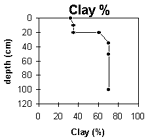 | The clay content increases significantly at the A/B horizon interface. |
Horizon | Horizon Depth (cm) | pH (water) | pH (CaCl2) | EC 1:5 | NaCl | Exchangeable Cations | |||
Ca | Mg | K | Na | ||||||
meq/100g | |||||||||
A1 | 0-10 | 5.4 | 4.8 | 0.28 | <0.03 | 4.4 | 3.3 | 1.2 | 0.42 |
A2 | 10-20 | 5.7 | 4.8 | 0.1 | 2.6 | 2.1 | 0.73 | 0.4 | |
B21 | 20-35 | 6 | 4.7 | 0.07 | 2.8 | 5.5 | 0.61 | 0.99 | |
B22 | 35-50 | 7 | 5.9 | 0.12 | 3.2 | 8.9 | 0.49 | 2.1 | |
B23 | 50-90 | 8.1 | 7.1 | 0.3 | 0.05 | 3 | 10 | 0.45 | 3.8 |
B24 | 90+ | 8.9 | 8.1 | 0.07 | 2.9 | 9.5 | 0.45 | 7.4 | |
Horizon | Horizon Depth (cm) | Exchangeable Aluminium mg/kg | Exchangeable Acidity meq/100g | Field Capacity pF2.5 | Wilting Point pF4.2 | Coarse Sand (0.2-2.0 mm) | Fine Sand (0.02-0.2 mm) | Silt (0.002-0.02 mm) | Clay (<0.002 mm) |
A1 | 0-10 | 10 | 15.7 | 4 | 24 | 31 | 32 | ||
A2 | 10-20 | 12 | 12.7 | 3 | 28 | 34 | 35 | ||
B21 | 20-35 | 43 | 19.2 | 6 | 13 | 20 | 61 | ||
B22 | 35-50 | 20.9 | 2 | 10 | 18 | 70 | |||
B23 | 50-90 | 20.4 | 1 | 10 | 19 | 70 | |||
B24 | 90+ |
Management Considerations:
Whole profile
- Plant Available Water Capacity (PAWC) is considered to be quite low (estimated at 42 mm) for this soil profile. This is based on an estimated effective rooting depth of 20 cm (i.e. surface soil). The dense and coarsely structured upper subsoil is likely to significantly restrict rooting depth. PAWC has been estimated using a model developed by Littleboy (1995) which uses analytical data for clay%, silt%, fine sand%, coarse sand % and wilting point.
Surface (A) Horizons
- The surface soil is strongly acid. This indicates that aluminium and manganese toxicity may occur. The level of exchangeable aluminium measured for this pit site is, however, quite low (<10 mg/kg) and unlikely to restrict the growth of aluminium sensitive species. Lime can be used to increase soil pH but it should be noted that a pH/aluminium test is best performed from samples taken across the paddock and bulked together. Other factors also need to be considered before lime is recommended (e.g. pasture species grown, method of application, local trial responses, soil surface structure and likely cost/benefit).
- Deficiencies of molybdenum and phosphorus may occur in the strongly acid surface soil. Increasing soil pH by lime application should enable phosphorus (from superphosphate) and molybdenum to become more available. If lime is required and pH is increased, then the availability of major nutrients should improve
- Manganese toxicity may also occur, particularly in poorly drained situations (as waterlogging may bring manganese into solution)
- The surface (A1) horizon is non-sodic but disperses slightly after remoulding. This indicates that tillage or over-stocking of the soil whilst in a moist to wet condition may result in some structural degradation (e.g. surface sealing, increased clodiness) occurring. Raindrop action on bare soil may have a similar effect, so it is important to maintain surface cover
- The level of soluble salts in the surface is low to moderate and may restrict the growth of salt sensitive species. These levels may be unnaturally high due to the effects of the dry season at the time of sampling (summer 1997). These levels are likely to decline following heavy rains and/or irrigation
- The relatively high wilting point value (16%) indicates that plants will be less able to utilise light rains falling on relatively dry soils (compared to lighter textured surface soils in the region)
- The presence of bleaching and rusty root channel mottling in the subsurface (A2) horizon indicates that periodic waterlogging occurs above the more slowly permeable subsoil. This horizon also has a low nutrient holding capacity
Subsoil (B) Horizons
- The dense and coarsely structured clay subsoil (B21) horizon is sodic and disperses slightly. Root and water movement will be restricted in the subsoil as a result of these conditions. The use of gypsum in association with deep ripping has been advocated by some researchers as an effective way to ameliorate sodic subsoils - but this may not be an economic option
- The presence of strong mottling in the subsoil indicates imperfect subsoil drainage
- The deeper subsoil displays vertic properties (i.e. slickensides). This indicates that significant shrinking and swelling occurs during wetting and drying cycles. This may have some engineering implications (e.g. disturbance to fencelines)