Victorian Resources Online (archived)
GP73
| Location: Upper Maffra West. | Australian Soil Classification: Melanic-Sodic, Eutrophic, Black DERMOSOL. |
| Geology: Holocene alluvium derived from Macalister River. | General Landscape Description: Floodplain of Macalister River. |
| Soil Mapping Unit: Newry. | Site Description: Dairy grazing paddock. |
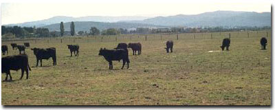 Site GP73 Landscape |
Soil Profile Morphology:
Surface Soil
| A1 | 0-15 cm | Very dark brown (10YR2/2); fine sandy clay loam; moderate medium polyhedral, parting to strong fine polyhedral structure; strong consistence dry; pH 5.5: | 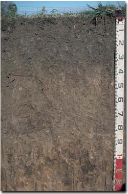 Site GP73 Profile |
| Subsoil | |||
| B21 | 15-35 cm | Very dark brown (10YR2/2); fine sandy clay loam; moderate coarse blocky, parting to moderate medium polyhedral structure in patches; strong consistence dry; pH 5.6: | |
| B22 | 35-90 cm | Dark brown (7.5YR3/2); fine sandy clay loam; weak coarse prismatic, parting to moderate coarse blocky structure; pH 6.6: | |
| B23 | 90+ cm | Strong brown (7.5YR4/6); silty clay loam; moderate coarse prismatic, parting to moderate coarse blocky structure; dark manganese stains along ped faces and pores; pH 7.9. | |
Key Profile Features:
- Lack of texture contrast throughout soil profile.
- Well structured surface and upper subsoil horizons (parting to many fine polyhedral shaped peds).
Soil Profile Characteristics:
Horizon | pH | Salinity Rating | ||
Surface (A1 horizon) | Strongly Acid | Moderate | Non-Sodic | None |
Subsoil (B21 horizon) | Moderately Acid | Very Low | Non-Sodic | None1 |
Deeper subsoil (at 90 cm) | Slightly Alkaline | Very Low | Sodic | None2 |
2 Complete dispersion after remoulding.
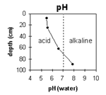 | Soil pH increases with depth down the profile. | 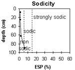 | The surface and upper subsoil is non-sodic. The subsoil becomes sodic at 90 cm depth. |
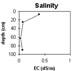 | The surface salinity rating is moderate. The subsoil is very low. | 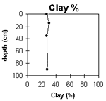 | The clay content remains fairly uniform throughout the soil profile. |
Horizon | Horizon Depth (cm) | pH (water) | pH (CaCl2) | EC 1:5 | NaCl | Exchangeable Cations | |||
Ca | Mg | K | Na | ||||||
meq/100g | |||||||||
A1 | 0-15 | 5.5 | 5 | 0.39 | 13 | 3.6 | 1.4 | 0.2 | |
B21 | 15-35 | 5.6 | 4.6 | 0.07 | 8.5 | 2.7 | 0.32 | 0.27 | |
B22 | 35-90 | 6.6 | 5.5 | <0.05 | 7.1 | 5 | 0.13 | 0.23 | |
B23 | 90+ | 7.9 | 6.6 | 0.06 | 6.4 | 6.6 | 0.13 | 0.76 | |
Horizon | Horizon Depth (cm) | Exchangeable Aluminium mg/kg | Exchangeable Acidity meq/100g | Field Capacity pF2.5 | Wilting Point pF4.2 | Coarse Sand (0.2-2.0 mm) | Fine Sand (0.02-0.2 mm) | Silt (0.002-0.02 mm) | Clay (<0.002 mm) |
A1 | 0-15 | <10 | 18.6 | 3 | 25 | 36 | 27 | ||
B21 | 15-35 | <10 | 13.7 | 1 | 28 | 34 | 30 | ||
B22 | 35-90 | 10.9 | 3 | 33 | 35 | 27 | |||
B23 | 90+ | 11.7 | 1 | 29 | 40 | 28 |
Management Considerations:
Whole Profile
- Plant Available Water Capacity (PAWC) is considered to be low-moderate (estimated at 80 mm) for this soil profile. This is based on an estimated effective rooting depth of 35 cm (i.e. surface soil and upper subsoil). The denser and coarsely structured deeper subsoil is likely to restrict rooting depth – although not to the extent that many of the more sodic subsoils in the region would. PAWC has been estimated using a model developed by Littleboy (1995) which uses analytical data for clay%, silt%, fine sand%, coarse sand % and wilting point
- The surface soil is well structured (parting to many fine polyhedral shaped peds) and will provide a good environment for roots and relatively rapid water movement.
- The surface soil is strongly acid. This indicates that aluminium and manganese toxicity may occur. However, the level of exchangeable aluminium measured for this pit site is quite low (<10 mg/kg) and unlikely to restrict the growth of aluminium sensitive species. A pH/aluminium test is best performed from samples taken across the paddock and bulked together. Other factors also need to be considered before lime is recommended (e.g. pasture species grown, method of application, local trial responses, soil surface structure and likely cost/benefit)
- Deficiencies of molybdenum and phosphorus may occur in the strongly acid surface soil. Increasing soil pH by lime application should enable phosphorus (from superphosphate) and molybdenum to become more available. If lime is required and pH is increased, then the availability of major nutrients should improve
- The level of soluble salts in the surface is moderate and may restrict the growth of salt sensitive species. These levels are likely to be unnaturally high due to the effects of the dry season at the time of sampling (summer 1997). Levels are likely to decline following heavy rains and/or irrigation
- The nutrient holding capacity (based on the sum of the exchangeable calcium, magnesium and potassium cations) of the surface (A1) horizon is high. The high levels of organic matter at this site are important for enhancing soil fertility as well as water holding capacity and surface soil structure
- The upper subsoil is non-sodic and reasonably well structured. Root and water movement will not be significantly restricted as a result
- The deeper subsoil becomes sodic and is more coarsely structured. It will more significantly restrict deeper root and water movement