Victorian Resources Online (archived)
GP30
| Location: Maffra. | Australian Soil Classification: Sodic, Eutrophic, Red CHROMOSOL. |
| Great Soil Group: solodic. | Geology: Quaternary prior stream deposits. |
| General Landscape Description: Level plain. | Mapping Unit: Tinamba. |
| Site Description: Irrigated dairy grazing paddock (non laser graded). |
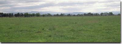 Site GP30 Landscape |
Soil Profile Morphology:
| Surface Soil | 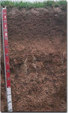 Site GP30 Profile | ||
| A1 | 0-40 cm | Reddish brown (5YR4/3); fine sandy clay loam; pH 5.2; gradual change to: | |
| A2 | 40-60 cm | Reddish brown (5YR5/4); sporadically bleached; fine sandy loam; macropores evident; pH 6.0; sharp change to: | |
| Subsoil | |||
| B21 | 60-100 cm | Yellowish red (5YR4/6) with dark stains (manganese oxide) on some ped faces; light medium clay; coarse prismatic, parting to strong coarse to medium blocky structure; strong consistence dry; some manganese flecks; pH 6.5; gradual change to: | |
| B22 | 100 + cm | Reddish brown (5YR5/4); light medium clay; coarse prismatic, parting to weak to moderate blocky structure; pH 7.7. | |
Key Profile Features:
- Strong texture contrast between the surface (A) horizon (13% clay) and the subsoil (B21) horizon (49% clay).
Soil Profile Characteristics:
Horizon | pH | Salinity Rating | ||
Surface (A1 horizon) | Strongly Acid | Very Low | Non-Sodic | None |
Subsoil (B21 horizon) | Slightly Acid | Very Low | Non-Sodic | None1 |
Deeper Subsoil (at 100+ cm) | Slightly Alkaline | Very Low | Sodic | None |
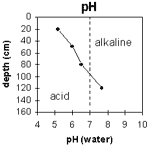 | The profile becomes increasingly alkaline with depth. | 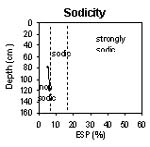 | The upper soil profile is non-sodic. The deeper subsoil becomes sodic. |
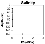 | The level of soluble salts is very low throughout the profile. | 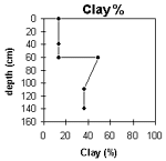 | The clay content increases significantly at the A/B horizon interface. |
Horizon | Horizon Depth (cm) | pH (water) | pH (CaCl2) | EC 1:5 | NaCl | Exchangeable Cations | |||
Ca | Mg | K | Na | ||||||
meq/100g | |||||||||
A1 | 0-40 | 5.2 | 4.4 | <0.05 | 1.6 | 0.39 | 0.1 | 0.13 | |
A2 | 40-60 | 6 | 4.8 | <0.05 | 1.2 | 0.49 | 0.08 | 0.08 | |
B21 | 60-100 | 6.5 | 5.4 | <0.05 | 3.6 | 6.2 | 0.35 | 0.48 | |
B22 | 100+ | 7.7 | 6.6 | <0.05 | 2.6 | 6.1 | 0.2 | 0.5 | |
Horizon | Horizon Depth (cm) | Exchangeable Aluminium mg/kg | Exchangeable Acidity meq/100g | Field Capacity pF2.5 | Wilting Point pF4.2 | Coarse Sand (0.2-2.0 mm) | Fine Sand (0.02-0.2 mm) | Silt (0.002-0.02 mm) | Clay (<0.002 mm) |
A1 | 0-40 | 51 | 5.7 | 24 | 5 | 2 | 55 | 28 | 13 |
A2 | 40-60 | 18 | 4 | 2 | 56 | 32 | 13 | ||
B21 | 60-100 | 29 | 16 | 1 | 27 | 23 | 49 | ||
B22 | 100+ | 23 | 12 | 3 | 41 | 20 | 36 |
Management Considerations:
Whole Profile
- Plant Available Water Capacity (PAWC) is considered to be low-moderate (estimated at 70 mm) for this soil profile. This is based on an estimated effective rooting depth of 60 cm (i.e. surface soil). The denser and more coarsely structured upper subsoil is likely to restrict rooting depth, although not to the same extent as some of the more sodic subsoils in the region. Much of the plant available water (i.e. 50 mm) will be in the surface (A1) horizon. PAWC has been estimated using a model developed by Littleboy (1995) which uses analytical data for clay%, silt%, fine sand%, coarse sand % and wilting point.
- The surface soil is relatively deep, providing a good environment for plant growth.
- The surface soil is strongly acid. This indicates that aluminium and manganese toxicity may occur. However, the level of exchangeable aluminium measured for this pit site is quite low (<10 mg/kg) and unlikely to restrict the growth of aluminium sensitive species. A pH/aluminium test is best performed from samples taken across the paddock and bulked together. Other factors also need to be considered before lime is recommended (e.g. pasture species grown, method of application, local trial responses, soil surface structure and likely cost/benefit).
- Deficiencies in molybdenum and phosphorus may occur in the strongly acid surface soil. Increasing soil pH by lime application should enable phosphorus (from superphosphate) and molybdenum to become more available. If lime is required, and pH is increased, then the availability of major nutrients should improve.
- The surface soil has a high fine sand content (55%). When cultivated in a dry condition it will become ‘powdery’ and subsequent rainfall may result in surface sealing occurring. Soils such as these rely to a large extent on organic matter for maintaining aggregation. The levels of organic carbon measured at the pit site (which may or may not be representative of the whole paddock) is low. Organic matter levels will build up under pasture but will decline if cropping takes place. Practices such as residue retention, minimum tillage and including pasture rotations could be utilised if cropping takes place. This will build up organic matter, improve aggregation, soil fertility and water holding capacity.
- The low wilting point value (i.e. 5%) of the surface horizon indicates that plants will be able to utilise very light rains when the soil is dry. However, due to the low water storage capacity, plants will soon suffer moisture stress unless further rainfall occurs. This is not likely to occur as these soils are irrigated.
- The presence of sporadic bleaching in the subsurface (A2) horizons indicates that periodic waterlogging occurs above the more slowly permeable subsoil.
- Water and root movement will be restricted by the coarsely structured upper subsoil. This horizon is non-sodic but does completely disperse after remoulding. It is likely to allow more water movement compared to the more sodic and dispersive subsoils in the region. Disturbance to this horizon by cultivation whilst moist should be avoided.