Victorian Resources Online (archived)
GP36
| Location: Heyfield. | Australian Soil Classification: Sodic, Eutrophic, Red DERMOSOL. |
| Geology: Quaternary alluvial prior stream deposits. | General Landscape Description: Level plain with prior stream activity. |
| Mapping Unit: Tinamba. | Site Description: Dairy grazing paddock. |
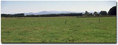 Site GP36 Landscape |
Soil Profile Morphology:
Surface Soil
| A1 | 0-5 cm | Dark yellowish brown (10YR4/4); silty clay loam; moderate medium polyhedral, parting to weak fine polyhedral structure; strong consistence dry; pH 6.5; clear change to: | 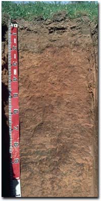 Site GP36 Profile |
| A2 | 5-20 cm | Brown (10YR5/3) sporadically bleached (10YR7/3d) with strong brown (7.5YR5/6) mottles; silty clay loam; structureless; very strong consistence dry; pH 6.9; clear and wavy change to: | |
| Subsoil | |||
| B1 | 20-30 cm | Yellowish red (5YR5/8); silty clay loam; weakly structured; strong to very strong consistence dry; pH 7.6; gradual change to: | |
| B21 | 30-50 cm | Yellowish red (5YR5/8) silty clay; weakly structured; firm consistence moist; pH 7.7; clear change to: | |
| B22 | 50-90 cm | Red (2.5YR5/8); organic stains on ped faces; medium clay; moderate coarse prismatic, parting to strong coarse blocky, parting to moderate blocky structure; shiny faced peds [organic staining on ped faces]; strong consistence dry; pH 7.8; gradual change to: | |
| B23 | 90+ cm | Red (2.5YR5/8); light medium clay; strong coarse prismatic, parting to strong coarse to medium polyhedral structure; shiny faced peds; contains a few (10%) manganese flecks and some fine mica, as well as pockets of reddish yellow (5YR6/6) fine sand; pH 8.0. | |
Key Profile Features:
- Lack of strong texture contrast between the surface (A) horizons and subsoil (B21) horizon.
Soil Profile Characteristics:
Horizon | pH | Salinity Rating | ||
Surface (A1 horizon) | Slightly Acid | Low | Sodic | None1 |
Subsoil (B21 horizon) | Slightly Alkaline | Very Low | Strongly Sodic | Slight2 |
Deeper subsoil (at 1 m) | Moderately Alkaline | Low | Strongly Sodic | Strong |
2 Complete dispersion after remoulding.
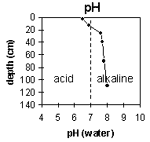 | The surface soil is slightly acid. The subsoil is slightly alkaline, becoming moderately alkaline at 1 m. | 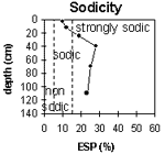 | The surface soil is sodic. The subsoil is strongly sodic. |
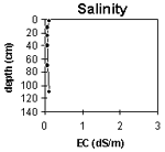 | The level of soluble salts is low throughout the soil profile. | 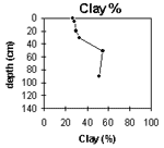 | The clay content gradually increases with depth. |
Horizon | Horizon Depth (cm) | pH (water) | pH (CaCl2) | EC 1:5 | Exchangeable Cations | |||
Ca | Mg | K | Na | |||||
meq/100g | ||||||||
A1 | 0-5 | 6.5 | 5.7 | 0.13 | 7.9 | 3.3 | 0.22 | 1.2 |
A2 | 5-20 | 6.9 | 5.8 | 0.08 | 4.8 | 1.8 | 0.2 | 0.87 |
B1 | 20-30 | 7.6 | 6.3 | 0.07 | 2.7 | 0.8 | 0.4 | 0.9 |
B21 | 30-50 | 7.7 | 6.3 | 0.07 | 2.1 | 0.9 | 0.1 | 1.2 |
B22 | 50-90 | 7.8 | 6.3 | 0.08 | 2.7 | 4.2 | 0.2 | 2.3 |
B23 | 90+ | 8 | 6.7 | 0.11 | 2.6 | 4.7 | 0.2 | 2.2 |
Horizon | Horizon Depth (cm) | Wilting Point pF4.2 | Coarse Sand (0.2-2.0 mm) | Fine Sand (0.02-0.2 mm) | Silt (0.002-0.02 mm) | Clay (<0.002 mm) |
A1 | 0-5 | 7 | 7 | 21 | 39 | 27 |
A2 | 5-20 | 11 | 1 | 26 | 44 | 28 |
B1 | 20-30 | 9 | 1 | 26 | 43 | 29 |
B21 | 30-50 | 11 | 1 | 24 | 43 | 32 |
B22 | 50-90 | 17 | 1 | 14 | 29 | 55 |
B23 | 90+ | 18 | 0 | 13 | 35 | 51 |
Management Considerations:
Surface (A) Horizons
- The surface (A1) horizon is sodic but does not disperse unless remoulded. Moderate dispersion occurs after remoulding, which indicates that structural degradation (e.g. surface sealing, increased cloddiness) may occur if the soil is cultivated or overstocked in a moist to wet condition. Also, raindrop action on bare surface soil may also promote dispersion. Surface cover should be maintained to protect against raindrop damage.
- The low wilting point value (i.e. 7%) of the surface (A1) horizon indicates that plants will be able to utilise very light rains when the soil is dry. However, due to the low water storage capacity, plants will soon suffer moisture stress unless further rain falls occur.
- The presence of sporadic bleaching in the subsurface (A2) horizon indicates that some periodic waterlogging occurs above the more slowly permeable subsoil.
- The soil texture of the subsoil increases gradually from the boundary of the surface horizon. This will present less of a physical barrier to water movement as compared to Sodosols in the region where there is a strong texture contrast between surface and subsoil horizons. However, the subsoil is strongly sodic and disperses (strongly at depth) which will result in conditions restricting water movement. Deep ripping (with gypsum application) has been recommended by some researchers as an effective ameliorative technique for sodic subsoils. This may not be an economically viable option.