Victorian Resources Online (archived)
GP38
| Location: Winnindoo. | Australian Soil Classification: Vertic (and Magnesic), Subnatric, Brown SODOSOL. |
| Great Soil Group: Solodic. | Geology: Pleistocene sediments. |
| General Landscape Description: Level plain. | Mapping Unit: Stratford. |
| Site Description: Road reserve with red gum (E. tereticornis). | |
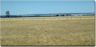 Site GP38 Landscape |
Soil Profile Morphology:
Surface Soil
| A1 | 0-17 cm | Dark greyish brown (10YR4/2); sandy loam; weak medium polyhedral, parting to weak fine polyhedral structure; firm consistence dry; pH 5.8: | 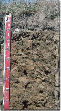 Site GP38 Profile |
| A2 | 17-20 cm | Pale brown (10YR6/3) with a yellowish brown (10YR5/8) mottles in patches; sandy loam; contains many (40%) ferruginous nodules (2-10 mm in size); pH 6.4; discontinuous change to: Note: Sometimes the A2 forms a hard capping on top of the B21 horizon. | |
| Subsoil | |||
| B21 | 20-60cm | Yellowish brown (10YR5/6) with strong brown diffuse (7.5YR5/8) mottles; medium heavy clay; weak coarse prismatic, parting to moderate coarse blocky and medium polyhedral structure; strong consistence dry; pH 6.5: | |
| B22 | 60-90 cm | Yellowish brown (10YR5/6) with diffuse reddish yellow (7.5YR6/8) and dark red (2.5YR4/8) mottles; moderate coarse prismatic, parting to coarse blocky structure; many slickensides; pH 7.3: | |
| B23 | 90+ cm | Yellowish brown (10YR5/6) with reddish yellow (7.5YR6/8) mottles; many slickensides present; pH 7.1. | |
Key Profile Features:
- Strong texture contrast between surface (A) horizon (17% clay) and sodic subsoil (B21) horizon (79% clay).
- Accumulation of ironstone nodules in the subsurface horizon.
- Vertic properties (i.e. significant shrink-swell characteristics) in deeper subsoil.
Soil Profile Characteristics:
Horizon | pH | Salinity Rating | ||
Surface (A1 horizon) | Moderately Acid | Low | - | None1 |
Subsoil (B21 horizon) | Slightly Acid | Very Low | Sodic | None2 |
Deeper subsoil (at 1 m) | Slightly Alkaline | Low | Extremely sodic | Strong2 |
2 Complete dispersion after remoulding.
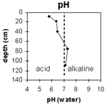 | The surface is moderately acid. The subsoil is slightly acid becoming slightly alkaline at 60 cm. | 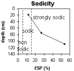 | The upper subsoil is sodic; becoming strongly sodic at depth. |
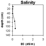 | The salinity rating is low throughout the profile. | 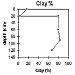 | The clay content increases significantly at the A/B horizon interface. |
Horizon | Horizon Depth (cm) | pH (water) | pH (CaCl2) | EC 1:5 | NaCl | Exchangeable Cations | |||
Ca | Mg | K | Na | ||||||
meq/100g | |||||||||
A1 | 0-17 | 5.8 | 5 | 0.06 | 2.7 | 2 | 0.29 | 0.4 | |
A2 | 17-20 | 6.4 | 5 | <0.05 | 1.1 | 1.3 | 0.09 | 0.29 | |
B21 | 20-60 | 6.5 | 5.1 | <0.05 | 3 | 10 | 0.4 | 1.8 | |
B22 | 60-90 | 7.3 | 6.3 | 0.24 | 1.6 | 32 | 0.2 | 12 | |
B23 | 90+ | 7.1 | 6.3 | 0.28 | 0.06 | 1 | 9.9 | 0.15 | 13 |
Horizon | Horizon Depth (cm) | Wilting Point pF4.2 | Coarse Sand (0.2-2.0 mm) | Fine Sand (0.02-0.2 mm) | Silt (0.002-0.02 mm) | Clay (<0.002 mm) |
A1 | 0-17 | 8 | 20 | 41 | 17 | 17 |
A2 | 17-20 | 5 | 30 | 39 | 17 | 3 |
B21 | 20-60 | 28 | 5 | 8 | 2 | 79 |
B22 | 60-90 | 31 | 3 | 5 | 1 | 83 |
B23 | 90+ | 9 | 14 | 6 | 67 |
Management Considerations:
Whole Profile
- Plant Available Water Capacity (PAWC) is considered to be quite low as effective rooting depth is likely to be restricted to the surface horizons. The dense and coarsely structured upper subsoil is likely to restrict rooting depth.
- The surface soil has a low nutrient holding capacity. Organic matter is important for enhancing fertility of soils such as these with high sand contents.
- The surface (A1) horizon disperses moderately after remoulding, indicating that structural degradation (e.g. surface sealing, exacerbated hardsetting, increased cloddiness) may occur if the soil is cultivated or overstocked in a moist to wet condition. Also, raindrop action on bare surface soil may also promote dispersion. Surface cover should be maintained to protect against raindrop damage.
- The coarsely structured upper subsoil is sodic and has a low exchangeable calcium to magnesium ratio (i.e. a high level of exchangeable magnesium relative to calcium). This may result in nutrient imbalances (e.g. calcium deficiency). At 50 cm the subsoil becomes strongly sodic and extremely sodic at 90 cm with strong dispersion. As a result of these conditions root and water movement is likely to be restricted in the subsoil. The use of gypsum in association with deep ripping, has been advocated by some researchers as an effective way to ameliorate sodic subsoils but this may not be an economic option. Deep ripping should not be carried out when the subsoil is in a moist to wet condition.
- The subsoil displays vertic properties (i.e. slickensides) which indicates that significant shrinking and swelling occurs with wetting and drying cycles. This may disturb the roots of some plants. The shrinking and swelling also has engineering implications (e.g. disturbance to fence lines).
- Traffickable most times.