Victorian Resources Online (archived)
GP48
| Location: Seaspray. | Australian Soil Classification: Grey SODOSOL (very thick sandy surface horizons). |
| Geology: Tertiary sediments later overlain by Pleistocene aeolian sediments. | General Landscape Description: Dune and swale landscape. |
| Mapping Unit: Gormandale with Stockdale (This soil profile more typically reflects Gormandale mapping unit). | Site Description: Lower slope of an old dune (0-5% slope) with a southerly aspect. This site occurs within native vegetation. |
| Native Vegetation: Original vegetation included Manna Gum (E. viminalis), Grey Box, Yertchuk (E. consideniana), Banksia, Tea-tree (Leptospernum sp.), Bracken. | |
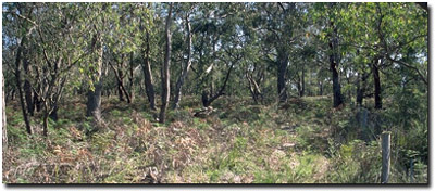 Site GP48 Landscape. |
Soil Profile Morphology:
Surface Soil
| A11 | 0-20 cm | Very dark greyish brown (10YR3/2); loamy sand; weak medium subangular blocky, parting to fine subangular blocky structure; slight hardpan; pH 4.3; clear change to: | 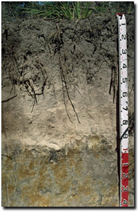 Site GP48 Profile. |
| A12 | 20-40 cm | Dark brown (10YR3/3); loamy sand; weak structure; pH 4.5; clear change to: | |
| A2 | 40-90 cm | Pale Brown (10YR6/3) conspicuously bleached (10YR8/2d); sand; massive; weak consistence dry; pH 5.6; abrupt change to: | |
| Subsoil | |||
| B1 | 90-95 cm | Light brownish grey (10YR6/2) with strong brown (7.5YR5/6) mottles; coarse sand; massive; strong consistence dry; clear but discontinuous change to: | |
| B21 | 95-120 cm | Grey (10YR6/1) with yellowish brown (10YR5/8) mottles; light medium clay; moderate coarse prismatic, parting to moderate coarse polyhedral structure; strong consistence dry; dark organic stains along prism faces; pH 6.2; clear and wavy change to: | |
| B22 | 120-140 cm | Grey (10YR5/1) with yellowish brown (10YR5/6) mottles; sandy loam (sandy); weak coarse prismatic, parting to weak coarse blocky structure; pH 6.3. | |
Key Profile Features:
| |
Soil Profile Characteristics: | |
Horizon | pH | Salinity Rating | ||
Surface (A11 horizon) | Extremely Acid | Very Low | Non-Sodic | None |
Subsoil (B21 at 1 m) | Slightly Acid | Moderate | Strongly Sodic | Moderate |
Deeper subsoil (at 1.3 m) | Slightly Acid | Moderate | Strongly Sodic | Slight |
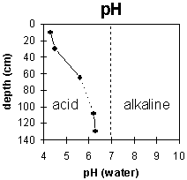 | 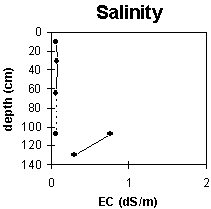 | 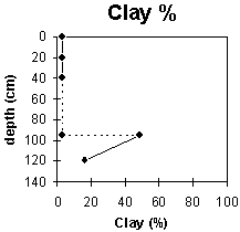 |
The surface soil is extremely acidic. The subsoil is slightly acid throughout. | The salinity rating in the surface is very low. The level of soluble salts is moderate in the deep subsoil. | The clay content increases sharply at the A/B horizon boundary. |
Horizon | Horizon Depth (cm) | pH (water) | pH (CaCl2) | EC 1:5 | NaCl | Exchangeable Cations | |||
Ca | Mg | K | Na | ||||||
meq/100g | |||||||||
A11 | 0-20 | 4.3 | 3.6 | 0.06 | 0.63 | 0.54 | 0.12 | 0.16 | |
A12 | 20-40 | 4.5 | 3.8 | 0.07 | 0.2 | 0.39 | 0.07 | 0.26 | |
A2 | 40-90 | 5.6 | 4.6 | 0.06 | 0.16 | 0.27 | 0.06 | 0.26 | |
B! | 90-95 | ||||||||
B21 | 95-120 | 6.2 | 5.7 | 0.76 | 0.16 | 0.4 | 5.2 | 0.2 | 3.1 |
B22 | 120-140 | 6.3 | 5.8 | 0.3 | 0.06 | 0.1 | 1.8 | 0.1 | 1 |
Horizon | Horizon Depth (cm) | Exchangeable Aluminium mg/kg | Exchangeable Acidity meq/100g | Field Capacity pF2.5 | Wilting Point pF4.2 | Coarse Sand (0.2-2.0 mm) | Fine Sand (0.02-0.2 mm) | Silt (0.002-0.02 mm) | Clay (<0.002 mm) |
A11 | 0-20 | 49 | 3.1 | 59 | 30 | 6 | 3 | ||
A12 | 20-40 | 83 | 2.3 | 53 | 35 | 6 | 3 | ||
A2 | 40-90 | 17 | 1.2 | 54 | 36 | 5 | 3 | ||
B! | 90-95 | ||||||||
B21 | 95-120 | 9.4 | 17.7 | 26 | 19 | 5 | 49 | ||
B22 | 120-140 | 5.9 | 41 | 38 | 7 | 16 |
Management Considerations:
Whole Profile
- Plant available water capacity (PAWC) is considered to be low (estimated at 75 mm) for the top metre of the soil profile. However, effective PAWC will be lower than this, as the subsoil is dense and coarsely structured which will restrict root movement. A significant proportion of the plant available water will be held in the surface horizon with its higher organic matter levels. PAWC has been estimated here using a model developed by Littleboy (1995) which uses analytical data for clay %, fine sand %, silt %, coarse sand % and wilting point value.
- The surface (A11) horizon is extremely acid. Aluminium toxicity can occur in strongly acid soils. The levels measured here are moderate (i.e. 49 mg/kg in the A11 and 83 mg/kg in the A12) which may affect the growth of aluminium sensitive species. A pH/aluminium test sampled across the paddock would be most appropriate to determine whether lime is needed to raise soil pH. However, other factors need to be considered before lime is recommended (e.g. pasture species grown, method of application, local trial responses, soil surface structure and likely cost/benefit).
- The sandy surface horizons are very well draining and have a low water storage capacity. The low wilting point value (i.e. 3 %) indicates that plants will be able to utilise light rains falling on dry soil. However, due to the low water storage capacity, plants will soon suffer moisture stress unless further rain occurs. Organic matter is an important source of nutrient holding capacity as well as enhancing water holding capacity in sandy soils.
- The sandy surface soil will also be prone to wind erosion if plant cover is removed where blow-outs can occur.
- All the surface horizons have a very low inherent fertility (based on the sum of the exchangeable cations). Such strongly leached soils are also likely to be naturally deficient in nitrogen, phosphorus, sulphur and potassium. Regular fertiliser inputs are required for intensive cropping. Nitrate and sulphate are readily soluble and easily removed by leaching. More regular but smaller applications of fertiliser will assist in reducing loss of nutrients through leaching. Nutrients lost through leaching may influence catchment water quality. Lime application will result in increased pH levels and make certain nutrients such as phosphorus more available to plants.
- Deficiencies of the trace element molybdenum (Mo) are likely to occur in acid sandy soils (soil adsorption of Mo increases as pH decreases, leading to reduced availability to plants). Any deficiencies can be confirmed by plant tissue analysis. Deficiencies can be remedied with molybdenum enriched fertiliser and foliar application. Lime application on acid soils will also make molybdenum more available to plants.
- Nutrients such as calcium and magnesium are usually low in strongly acid soils. Foliar spray application, adjusting soil pH with lime application or using calcium based fertilisers can be utilised to treat deficiencies.
- The trace element boron leaches rapidly through acid sandy soils and deficiencies are likely to occur. Over-liming in sandy soils can make trace elements such as boron, zinc and manganese less available. Organic matter can complex with metal ions enabling trace elements (iron, zinc, copper) to become more available to plants.
- Manganese toxicity may also occur in strongly acid soils, particularly when poorly drained (as waterlogging may bring manganese into solution).
- The sub-surface (A2) horizon is extremely infertile, so building up the surface (A11) soil should be a prime objective.
- The dense and coarsely structured upper (B21) subsoil is strongly sodic (with a very low exchangeable calcium to magnesium ratio (0.1) and moderately dispersive. This will restrict the downward movement of plant roots and water. In some situations, the temporary build up of water on top of this less permeable layer may be beneficial for deeper-rooted plants in that it prevents deep drainage of water away from plant roots.
- The upper (B21) subsoil has a relatively low inherent fertility throughout (based on the sum of the exchangeable calcium, magnesium and potassium cations). The cations are dominated by exchangeable magnesium which may create nutrient imbalances. For example, high levels of exchangeable magnesium may result in potassium deficiencies in some soils (Baker and Eldershaw 1993). Calcium deficiencies may also occur.
- The level of soluble salts is moderate in the deeper subsoil (i.e. from 95 cm depth). This is only likely to restrict the growth of deeper-rooted salt sensitive species.