Victorian Resources Online (archived)
GP70
| Location: Clydebank Landcare Group. | Australian Soil Classification: Hypocalcic, Mottled-Subnatric, Brown SODOSOL. |
| Great Soil Group: solodic. | Geology: Pleistocene flood plain. (Early Pleistocene torrent gravels occur at 10 m depth). |
| General Landscape Description: Level plain above present flood plain. | Mapping Unit: Montgomery [This soil is equivalent to Bundalaguah clay loam as mapped by Skene and Walbran (1948)]. |
| Site Description: Dairy grazing paddock. | |
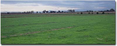 Site GP70 Landscape |
Soil Profile Morphology:
Surface Soil
| A1 | 0-10 cm | Very dark greyish brown (10YR3/2); fine sandy clay loam; weak coarse blocky structure; strong consistence dry; pH 5.4: | 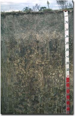 Site GP70 Profile |
| A21 | 10-30 cm | Very dark greyish brown (10YR3/2) with a slight sporadic bleach; rusty root channel mottling present; fine sandy clay loam; weak coarse blocky structure; strong consistence dry; pH 5.1: | |
| A22 | 30-40 cm | Light brown (7.5YR6/4) with very dark brown (10YR3/2) and very faint yellowish brown (10YR5/6) mottles; fine sandy clay loam; moderate coarse prismatic, parting to moderate coarse blocky structure; strong consistence dry; pH 5.9; sharp change to: | |
| Subsoil | |||
| B21 | 40-80 cm | Strong brown (7.5YR5/8) with brown (7.5YR5/2) mottles; light medium clay; strong coarse prismatic, parting to strong coarse blocky structure; strong consistence dry; dark stains on ped faces; pH 6.9; gradual change to: | |
| B22 | 80-120 cm | Brown (7.5YR5/4) with brownish yellow (10YR6/8) mottles [and dark greyish brown (10YR4/2) infill]; dark stains along root channels; light medium clay; strong coarse prismatic structure; strong consistence dry; pH 8.8; gradual change to: | |
| B23 | 120+ cm | Reddish grey (5YR5/2) with reddish yellow (7.5YR6/8) and light brownish grey (10YR6/2) mottles; dark stains along root channels; light clay; strong coarse prismatic structure; strong consistence dry; pH 9.3. | |
Key Profile Features:
- Strong texture contrast between surface (A) horizons and subsoil (B21) horizon.
Soil Profile Characteristics:
Horizon | pH | Salinity Rating | ||
Surface (A1 horizon) | Strongly Acid | Moderate | Non-Sodic | None1 |
Subsoil (B21 horizon) | Slightly Acid | Low-Moderate | Sodic | Strong2 |
Deeper subsoil (at 1 m) | Strongly Alkaline | Low- Moderate | Strongly Sodic | Complete |
2 Complete dispersion after remoulding.
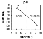 | The surface is strongly acid. The subsoil is slightly acid becoming strongly alkaline at 90 cm depth. | 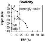 | The surface is non-sodic. The subsoil is sodic becoming strongly sodic at 75 cm depth. |
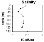 | The surface salinity rating is moderate. The subsoil rating is low to moderate. | 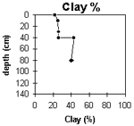 | The clay content increases significantly at the A/B horizon interface. |
Horizon | Horizon Depth (cm) | pH (water) | pH (CaCl2) | EC 1:5 | NaCl | Exchangeable Cations | |||
Ca | Mg | K | Na | ||||||
meq/100g | |||||||||
A1 | 0-10 | 5.4 | 4.8 | 0.45 | 0.08 | 6.8 | 2.5 | 0.3 | 0.5 |
A21 | 10-30 | 5.1 | 4.5 | 0.26 | 0.06 | 5 | 1.8 | 0.2 | 0.3 |
A22 | 30-40 | 5.9 | 4.8 | 0.19 | 2.9 | 3 | 0.15 | 1.3 | |
B21 | 40-80 | 6.9 | 6 | 0.35 | 3.6 | 6.6 | 0.2 | 1.2 | |
B22 | 80-120 | 8.8 | 7.8 | 0.36 | 2.3 | 7 | 0.2 | 3.4 | |
B23 | 120+ | 9.3 | 8.1 | 0.32 | 1.7 | 5.4 | <0.1 | 3.1 | |
Horizon | Horizon Depth (cm) | Exchangeable Aluminium mg/kg | Exchangeable Acidity meq/100g | Field Capacity pF2.5 | Wilting Point pF4.2 | Coarse Sand (0.2-2.0 mm) | Fine Sand (0.02-0.2 mm) | Silt (0.002-0.02 mm) | Clay (<0.002 mm) |
A1 | 0-10 | 22 | 15.4 | 5 | 30 | 34 | 22 | ||
A21 | 10-30 | 29 | 11.7 | 3 | 34 | 34 | 25 | ||
A22 | 30-40 | <10 | 10.1 | 4 | 36 | 33 | 26 | ||
B21 | 40-80 | <10 | 16.8 | 1 | 29 | 27 | 43 | ||
B22 | 80-120 | 16.5 | 2 | 23 | 37 | 40 | |||
B23 | 120+ |
Management Considerations:
Whole Profile
- Plant Available Water Capacity (PAWC) is considered to be low-moderate (estimated at 80 mm) for this soil profile. This is based on an estimated effective rooting depth of 40 cm (i.e. surface soil). The dense and coarsely structured upper subsoil is likely to restrict rooting depth. PAWC has been estimated using a model developed by Littleboy (1995) which uses analytical data for clay%, silt%, fine sand%, coarse sand % and wilting point.
- The upper surface horizons are strongly acid. This indicates that aluminium and manganese toxicity may occur. The level of exchangeable aluminium measured at this site is low (22 mg/kg) and unlikely to restrict the growth of aluminium sensitive species. Lime can be used to increase soil pH but a pH/aluminium test on a bulked sample (from across the paddock) would be most appropriate to determine if lime is needed to raise soil pH. Other factors also need to be considered before lime is recommended (e.g. pasture species grown, method of application, local trial responses, soil surface structure and likely cost/benefit).
- Deficiencies in molybdenum and phosphorus may also occur in this strongly acid environment. Manganese toxicity can also occur particularly when drainage is poor (as waterlogging may bring manganese into solution.
- The surface (A1) horizon is non-sodic but disperses slightly after remoulding. This indicates that tillage or over-stocking of the soil whilst in a moist to wet condition may result in structural degradation occurring (e.g. surface sealing, increased cloddiness). Raindrop action on bare soil may have a similar affect, so it is important to maintain adequate surface cover.
- The level of soluble salts in the surface is moderate and may affect salt sensitive species. However, these levels may be unnaturally high due to the effects of the dry season at the time of sampling (i.e. summer 1997) and are likely to decline following heavy rains or irrigation.
- The presence of bleaching and mottling in the subsurface (A2) horizon indicates that periodic waterlogging occurs above the more slowly permeable subsoil.
- The dense and coarsely structured subsoil (B21) horizon is sodic and disperses strongly in water. Root and water movement in the subsoil will be significantly restricted by these conditions. The subsoil becomes strongly sodic at 75 cm depth and complete dispersion occurs – indicating significantly restricted deeper drainage. Deep ripping, together with gypsum application, has been advocated by some researchers as an ameliorative technique for sodic and dispersive subsoils. However, this may not be an economic option.