Victorian Resources Online (archived)
GP71
| Location: Near Lake Wellington. | Australian Soil Classification: Mottled-Sodic, Hypocalcic, Brown DERMOSOL. |
| Geology: Quaternary and Holocene swamp deposits. | General Landscape Description: Low lying level plain. |
| Mapping Unit: Wandocka. | Site Description: Grazing paddock. |
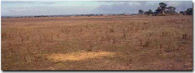 Site GP71 Landscape |
Soil Profile Morphology:
Surface Soil
| A1 | 0-15 cm | Black (10YR2/1); clay loam; weak coarse blocky, parting to moderate medium polyhedral, parting to fine polyhedral structure; strong consistence dry; pH 5.8; gradual change to: | 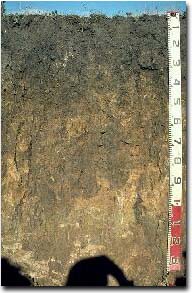 Site GP71 Profile |
| Subsoil | |||
| B21 | 15-30 cm | Black (10YR2/1); light medium clay; moderate coarse prismatic structure; strong consistence dry; pH 6.4; gradual and wavy change to: | |
| B22 | 30-60 cm | Yellowish brown (10YR5/6) mixed with very dark greyish brown (10YR3/2); medium clay; strong coarse prismatic, parting to moderate coarse blocky structure; strong consistence dry; pH 8.2; gradual and wavy change to: | |
| B23 | 60-90 cm | Light brown (7.5YR6/4) with brownish yellow (10YR6/8) mottles; medium clay; strong coarse prismatic, parting to moderate coarse blocky structure; strong consistence dry; pH 8.6; gradual and wavy change to: | |
| B24 | 90+ cm | Grey (10YR6/1) with brownish yellow (10YR6/6) and light brown (7.5YR6/4) mottles; light medium clay; contains very few (1-2%) soft carbonate in patches; slightly micaceous; pH 8.9. | |
Key Profile Features:
- Lack of strong texture contrast between surface (A) and subsoil (B21) horizons.
Soil Profile Characteristics:
Horizon | pH | Salinity Rating | ||
Surface (A1 horizon) | Moderately Acid | Low-Moderate | Non-Sodic | None1 |
Subsoil (B21 horizon) | Slightly Acid | Very Low | Sodic | None2 |
Deeper Subsoil (at 90 cm) | Strongly Alkaline | High | Extremely Sodic | Slight1 |
2 Complete dispersion after remoulding.
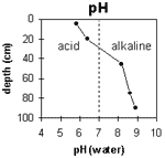 | The soil profile becomes increasingly alkaline with depth. | 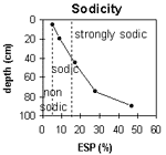 | The surface is non-sodic. The subsoil is sodic becoming strongly sodic at 40 cm depth. |
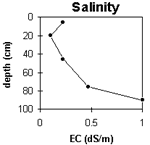 | The surface salinity is low to moderate. The upper subsoil is very low becoming high at depth. | 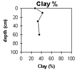 | The clay content changes only gradually with depth. |
Horizon | Horizon Depth (cm) | pH (water) | pH (CaCl2) | EC 1:5 | NaCl | Exchangeable Cations | |||
Ca | Mg | K | Na | ||||||
meq/100g | |||||||||
A1 | 0-10 | 5.8 | 5 | 0.22 | 7 | 4.5 | 0.65 | 1.3 | |
B21 | 10-30 | 6.4 | 5.2 | 0.1 | 5.9 | 5.8 | 0.34 | 1.2 | |
B22 | 30-60 | 8.2 | 7.2 | 0.22 | 5.1 | 8.8 | 0.31 | 2.8 | |
B23 | 60-90 | 8.6 | 7.7 | 0.47 | 3.8 | 6.6 | 0.23 | 4 | |
B24 | 90+ | 8.9 | 8.3 | 1 | 3.5 | 5.7 | <0.1 | 8.1 | |
Horizon | Horizon Depth (cm) | Exchangeable Aluminium mg/kg | Exchangeable Acidity meq/100g | Field Capacity pF2.5 | Wilting Point pF4.2 | Coarse Sand (0.2-2.0 mm) | Fine Sand (0.02-0.2 mm) | Silt (0.002-0.02 mm) | Clay (<0.002 mm) |
A1 | 0-10 | 16 | 13 | 16 | 5 | 35 | 22 | 28 | |
B21 | 10-30 | 13.9 | 3 | 30 | 21 | 42 | |||
B22 | 30-60 | 16.2 | 3 | 38 | 22 | 33 | |||
B23 | 60-90 | 16 | 39 | 21 | 36 | ||||
B34 | 90+ | 18.5 |
Management Considerations:
Whole Profile
- Plant Available Water Capacity (PAWC) is considered to be low (estimated at 35 mm) for this soil profile. This is based on an estimated effective rooting depth of 15 cm (i.e. surface soil). The dense and coarsely structured subsoil is likely to restrict rooting depth. PAWC has been estimated using a model developed by Littleboy (1995) which uses analytical data for clay%, silt%, fine sand%, coarse sand % and wilting point.
- The surface (A1) horizon is non-sodic but disperses slightly after remoulding. This indicates that tillage or over-stocking of the soil whilst in a moist to wet condition may result in some structural degradation occurring (e.g. surface sealing, increased cloddiness). Raindrop action on bare soil may have a similar effect, so it is important to maintain surface cover.
- The dense and coarsely structured subsoil (B21) horizon is sodic and will restrict root and water movement.
- The level of soluble salts becomes quite high in the deeper subsoil. This may restrict the growth of deeper rooted salt-sensitive species.