Victorian Resources Online (archived)
GP72
| Location: Clydebank. | Australian Soil Classification: Sodic, Eutrophic, Red DERMOSOL |
| Geology: Quaternary prior stream deposits associated with Avon River. | General Landscape Description: Gently undulating plain (higher "red bank" country). |
| Mapping Unit: Clydebank | Site Description: Dairy grazing paddock. |
 Site GP72 Landscape |
Soil Profile Morphology:
| Surface Soil | 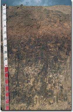 Site GP72 Soil Profile | ||
| A11 | 0-15 cm | Dark brown (10YR3/3); light fine sandy loam; hardsetting surface condition; weakly structured; very firm consistence dry; macropores present; pH 5.1: | |
| A12 | 15-30 cm | Dark brown (7.5YR3/4); light fine sandy clay loam; weak to moderate medium polyhedral structure; very firm consistence dry; macropores present; pH 5.4: | |
| Subsoil | |||
| B1 | 30-50 cm | Yellowish red (5YR4/6); fine sandy clay loam (becoming light clay with depth); moderate coarse blocky structure; strong consistence dry; many pores present; pH 6.9; clear change to: | |
| B21 | 50-90 cm | Yellowish red (5YR4/6); light medium clay; strong coarse prismatic, parting to strong coarse to medium blocky structure; strong consistence dry; contains few (5%) manganese stains; pH 7.5: | |
| B22 | 90-120 cm | Light brown (7.5YR6/3) with strong brown (7.5YR5/8) and light reddish brown (5YR6/3) mottles; medium clay; strong coarse prismatic, parting to strong coarse blocky structure; strong consistence dry; gypsum present; pH 8.6 | |
| B23 | 120+ cm | Pinkish grey (7.5YR6/2) with strong brown (7.5YR5/8) mottles; light clay; strong coarse prismatic structure; strong consistence dry; pH 8.8. | |
Soil Profile Characteristics:
pH | Salinity Rating | |||
Surface (A1 Horizon) | Strongly Acid | Moderate | non-sodic | __ |
Subsoil (B21 Horizon) | Slightly Alkaline | Very Low | Sodic | Slight1 |
Deeper Subsoil (at 110cm) | Strongly Alkaline | Low | Strongly Sodic | Complete |
 | The soil profile becomes increasingly alkaline with depth. | 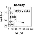 | The upper subsoil is sodic; becoming strongly sodic at 80 cm depth. |
 | The surface salinity rating is moderate to high. The subsoil rating is low. |  | The clay content increases gradually with depth down the soil profile. |
Horizon | Horizon Depth (cm) | pH (water) | pH (CaCl2) | EC 1:5 | NaCl | Exchangeable Cations | |||
Ca | Mg | K | Na | ||||||
meq/100g | |||||||||
A11 | 0-15 | 5.1 | 4.7 | 0.56 | 4 | 1.7 | 1.3 | 0.58 | |
A12 | 15-30 | 5.4 | 4.6 | 0.15 | 2.8 | 0.98 | 0.8 | 0.27 | |
B1 | 30-50 | 6.9 | 5.9 | 0.08 | 3.5 | 2.7 | 0.22 | 0.58 | |
B21 | 50-90 | 7.5 | 6.5 | 0.16 | 51 | 6.8 | 0.33 | 1.7 | |
B22 | 90-120 | 8.6 | 7.4 | 0.23 | 4.6 | 6.9 | 0.2 | 3.2 | |
B23 | 120+ | 8.8 | 7.7 | 0.35 | <0.1 | 4.4 | 0.2 | 3.1 | |
Horizon | Horizon Depth (cm) | Exchangeable Aluminium mg/kg | Exchangeable Acidity meq/100g | Field Capacity pF2.5 | Wilting Point pF4.2 | Coarse Sand (0.2-2.0 mm) | Fine Sand (0.02-0.2 mm) | Silt (0.002-0.02 mm) | Clay (<0.002 mm) |
A11 | 0-15 | <10 | 8.5 | 8 | 42 | 26 | 20 | ||
A12 | 15-30 | <10 | 6.3 | 7.9 | 8 | 44 | 26 | 20 | |
B1 | 30-50 | 10.1 | 6 | 32 | 31 | 31 | |||
B21 | 50-90 | 17.1 | 3 | 15 | 31 | 49 | |||
B22 | 90-120 | ||||||||
B23 | 120+ |
Management Considerations:
Whole Profile
- Plant Available Water Capacity PAWC) is considered to be moderate (estimated at 85 mm) for this soil profile. This is based on an estimated effective rooting depth of 50 cm (i.e. surface soil and upper subsoil). The dense and coarsely structured deeper subsoil (from 50 cm depth) is likely to restrict rooting depth. PAWC has been estimated using a model developed by Littleboy (1995) which uses analytical data for clay%, silt%, fine sand %, coarse sand % and wilting point.
- The surface soil is hardsetting and has a high fine sand and silt content. Organic matter is important in such soils for maintaining surface soil aggregation and promoting soil fertility and water holding capacity. Organic matter levels will decline if cropping takes place and can be improved by adopting practices such as residue retention, minimum tillage and utilising pasture rotations.
- The nutrient holding capacity of the surface (A1) horizon (based on the sum of the exchangeable calcium, magnesium and potassium cations) is low. Organic matter is important for maintaining soil fertility on such soils.
- The surface soil is strongly acid. This indicates that aluminium toxicity may occur. However, the level of exchangeable aluminium measured for this pit site is quite low (<10 mg/kg) and unlikely to restrict the growth of aluminium sensitive species. A pH/aluminium test is best performed from samples taken across the paddock and bulked together. However, other factors also need to be considered before lime is recommended e.g. pasture species grown, method of application, local trial responses, soil surface structure and likely cost/benefit.
- Deficiencies in molybdenum and phosphorus may occur in the strongly acid surface soil. Increasing soil pH by lime application should enable phosphorus (from superphosphate) and molybdenum to become more available. If lime is required, and pH is increased, then the availability of major nutrients should improve.
- The level of soluble salts in the surface is moderate and may restrict the growth of salt sensitive species. These levels may be unnaturally high due to the effects of the dry season at the time of sampling (i.e. summer 1997) and are likely to decline to more natural levels following periods of irrigation or heavy rainfall.
- The upper subsoil (B1) horizon is reasonably porous and likely to be well drained. It is also not likely to significantly restrict root movement. The dense and coarsely structured deeper subsoil (i.e. from 50 cm depth) is sodic and slight dispersion was noted in laboratory assessments. Some restricted root and water movement in the deeper subsoil could be expected. Generally, the more gradual texture change at the A/B horizon interface is likely to present fewer restrictions to water and root movement than the more abrupt texture change common with many soils in the region.
- The deeper subsoil becomes strongly sodic at 80 cm depth and complete dispersion occurs. Deeper drainage is likely to be restricted as a result.