Victorian Resources Online (archived)
GP78
| Location: Bushy Park. | Australian Soil Classification: Magnesic, Mottled-Mesonatric, Yellow SODOSOL |
| Great Soil Group: solodic | Geology: Pleistocene sediments (quartz gravel probably derived from Carboniferous sediments in uplands). |
| General Landscape Description: Gently undulating plain. | Mapping Unit: Briagolong |
| Site Description: Grazing paddock. | |
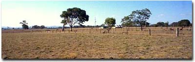 Site GP78 Landscape |
Soil Profile Morphology:
| Surface Soil | 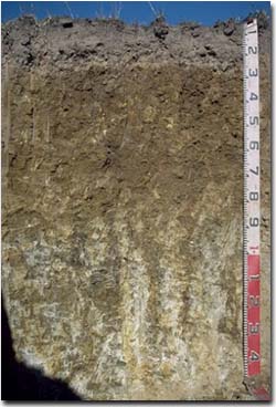 Site GP78 Profile | ||
| A1 | 0-10 cm | Dark brown (10YR3/3); fine sandy loam; weakly structured, very firm consistence dry; pH 5.1: | |
| A2 | 10-25 cm | Brown (7.5YR5/4) bleached (7.5YR7/2); fine sandy loam; weak structure; very firm consistence dry; contains many (50%) quartz fragments (1-5 mm in size) and pebbles; pH 5.4; sharp change to: | |
| Subsoil | |||
| B21 | 25-50 cm | Brownish yellow (10YR6/6); medium clay; moderate coarse prismatic, parting to moderate coarse blocky structure; strong consistence dry; pH 6.7: | |
| B22 | 50-80 cm | Light olive brown (2.5Y5/4) with strong brown (7.5YR5/6) mottles; medium clay; moderate coarse prismatic, parting to moderate coarse blocky structure; strong consistence dry; pH 7.7 | |
| B23 | 80-130 cm | Yellowish brown (10YR5/6) with strong brown (7.5YR5/8) and grey (10YR6/1) mottles; light medium clay; moderate coarse prismatic parting to moderate coarse blocky structure; strong consistence dry; contains few (5-10%) manganese flecks; pH 8.0 | |
| B24 | 130+ cm | Light grey (10YR7/1) with strong brown (7.5YR5/8) mottles; contains many (30%) rounded quartz pebbles (3-5 mm in size). Iron cemented river gravels occur from 150 cm depth |
Key Profile Features:
- Strong texture contrast between surface (A) and subsoil (B21) horizons.
- Conspicuously bleached subsurface (A2) horizon.
- Contains many (50%) quartz pebbles in the subsurface (A2) horizon.
Soil Profile Characteristics:
pH | Salinity Rating | |||
Surface (A1 Horizon) | Strongly Acid | Moderate | Non-Sodic | --- |
Subsoil (B21 Horizon) | Slightly Acid | Very Low | Strongly Sodic | Complete |
Deeper Subsoil (at 1m) | Moderately Alkaline | Low | Strongly Sodic | Complete |
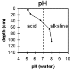 | The soil profile becomes increasingly alkaline with depth. | 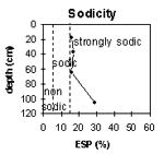 | The surface soil is non-sodic. The subsoil is strongly sodic throughout. |
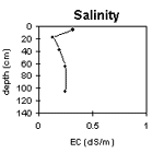 | The surface salinity rating is moderate. The subsoil rating is low. | 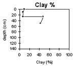 | The clay content increases significantly at the A/B horizon interface. |
Horizon | Horizon Depth (cm) | pH (water) | pH (CaCl2) | EC 1:5 | NaCl | Exchangeable Cations | |||
Ca | Mg | K | Na | ||||||
meq/100g | |||||||||
A1 | 0-10 | 5.1 | 4.5 | 0.32 | 3.1 | 1.1 | 0.5 | 0.1 | |
A2 | 10-25 | 5.4 | 4.6 | 0.13 | 0.72 | 0.44 | 0.47 | 0.3 | |
B21 | 25-50 | 6.7 | 5.7 | 0.19 | 0.82 | 11 | 0.47 | 2.5 | |
B22 | 50-80 | 7.7 | 6.6 | 0.25 | 0.2 | 9.2 | 9.2 | 3.4 | |
B23 | 80-130 | 8 | 6.8 | 0.25 | 0.2 | 8.5 | 0.2 | 3.5 | |
B24 | 130+ | ||||||||
Horizon | Horizon Depth (cm) | Exchangeable Aluminium mg/kg | Exchangeable Acidity meq/100g | Field Capacity pF2.5 | Wilting Point pF4.2 | Coarse Sand (0.2-2.0 mm) | Fine Sand (0.02-0.2 mm) | Silt (0.002-0.02 mm) | Clay (<0.002 mm) |
A1 | 0-10 | <10 | 5.1 | 23 | 46 | 18 | 9 | ||
A2 | 10-25 | 11 | 2.6 | 27 | 48 | 17 | 7 | ||
B21 | 25-50 | 17.7 | 10 | 26 | 15 | 48 | |||
B22 | 50-80 | 14.7 | 8 | 29 | 19 | 42 | |||
B23 | 80-130 | ||||||||
B24 | 130+ |
Management Considerations:
Whole Profile
- Plant Available Water Capacity (PAWC) is considered to be quite low (estimated at 27 mm) for this soil profile. This is based on an estimated effective rooting depth of 25 cm (i.e. surface soil). The dense and coarsely structured upper subsoil is likely to restrict rooting depth. Most of the plant available water will be in the surface (A1) horizon as water storage is more limited in the stony A2 horizon. PAWC has been estimated using a model developed by Littleboy (1995) which uses analytical data for clay%, silt%, fine sand%, coarse sand % and wilting point
- The surface soil is strongly acid. This indicates that aluminium toxicity could occur. However, the level of exchangeable aluminium measured at this site is very low (<10 mg/kg). These levels are unlikely to affect plant growth. A pH/aluminium test on a bulked sample (from across the paddock) would be most appropriate, however, to determine if lime is needed to raise soil pH
- Manganese toxicity may also occur in strongly acid soils, particularly if poorly drained (as waterlogging may bring manganese into solution)
- Deficiencies in molybdenum, potassium and phosphorus may also occur in the strongly acid and sandy surface soil. If lime is needed to raise soil pH then this should result in increased nutrient availability
- The level of soluble salts in the surface is moderate to high and may restrict the growth of salt sensitive species. These levels may be unnaturally high due to the effects of the dry season at the time of sampling (i.e. summer 1997) and are likely to decline to more natural levels following periods of irrigation or heavy rainfall
- The surface (A1) horizon has a low nutrient holding capacity (based on the sum of the exchangeable calcium, magnesium and potassium cations). Organic matter is important for maintaining soil fertility, water holding capacity and enhancing surface soil structure; especially in soils such as these with high fine sand contents
- The low wilting point value (i.e. 5%) of the surface (A1) horizon indicates that plants will be able to utilise very light rains when the soil is dry. However, due to the low water storage capacity, plants will soon suffer moisture stress unless further rainfall occurs
- The presence of a conspicuously bleached subsurface (A2) horizon indicates that periodic waterlogging occurs above the more slowly permeable subsoil. This horizon also has a very low inherent fertility and will become ‘spewy’ when wet
- The dense and coarsely structured subsoil is strongly sodic and disperses completely. This will result in significantly restricted root and water movement into the subsoil. The use of gypsum in association with deep ripping has been advocated by some researchers as an effective way to ameliorate sodic subsoils, but this may not be an economic option. Deep ripping should not be carried out when the subsoil is in a moist to wet condition
- The low exchangeable calcium to magnesium ratio (0.1) in the subsoil indicates that some nutrient imbalances (eg. calcium deficiency) could occur