Victorian Resources Online (archived)
Grey Clay Plains
Description of the Land System
| Landform and Distribution Generally level to very gently undulating plains occupying low-lying areas between north-south trending rises and low hills. Gilgai microrelief is common. The parent material is a combination of past lowland swamp deposits and clay deposition (probably estuarine, riverine and lacustrine) behind stranded beach ridges (Blackburn et al. 1966). Small areas of Grey Clay Plains occur as a minor component of the Undulating Low Hills unit (in particular the Lawloit/Diapur ridge). This clay was probably deposited by wind (i.e. aeolian) from lower areas. | 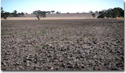 This photo shows the Grey Clay Plains unit in the foreground. A NNW/SSE trending ridge (Undulating Low Hills unit) occurs in the background. |
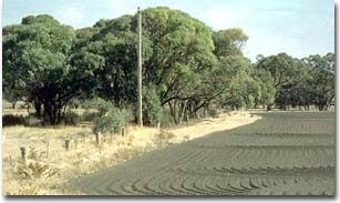 Black Box (Eucalyptus largiflorens) and Lignum Bush (Muehlenbeckia cunninghamii) occurs in lower lying areas. This example is a roadside reserve near Woorak. |
|
Grey Vertosols are often referred to as 'grey cracking clays' (see Site LS3) and are the dominant soil type. These soils crack deeply on drying and usually have a self-mulching surface soil condition. Less often the surface soil is weakly structured and hard with significant surface cracking. Surface horizons are generally slightly alkaline (but may be slightly acid in undisturbed areas) and are strongly structured and dark grey in colour. Subsoils are sodic to strongly sodic and become paler in colour and more alkaline with depth. The zone of maximum carbonate accumulation usually occurs below 50 cm depth.
A more calcareous variant with carbonate accumulations close to the surface also occurs and is referred to as a Hypercalcic Grey Vertosol (see Site LS20). The surface horizons are usually moderately to strongly alkaline and are underlain by sodic and very strongly alkaline subsoils with moderate amounts of soft carbonate at the top of the subsoil.
Where the Grey Clay Plains unit grades into the lower slopes of the Gently Undulating Rises unit, a Sodosol with vertic properties at depth can occur i.e. a Vertic Sodosol (see Site LS2). These soils seem to form an intergrade with the Vertosols.
Example Soil Profiles:
Self-Mulching, Grey Vertosol (near Kinimakatka)
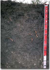 | Surface Soil | ||
| A1 | 0-5 cm | Dark grey; medium clay; self-mulching: | |
| Subsoil | |||
| B21 | 5-90 cm | Grey; heavy clay; strong coarse prismatic, parting to coarse blocky structure; pH 8.3: | |
| B22 | 90-140 cm | Light olive grey; medium heavy clay; strong fine blocky structure; soft and hard carbonate common; pH 9.1. | |
| This Grey Vertosol has a strongly sodic subsoil that disperses and a high level of soluble salts in the deeper subsoil. | |||
Hypercalcic, Self-Mulching Grey Vertosol (near Woorak)
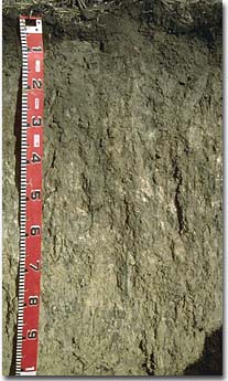 | Surface Soil | ||
| A11 | 0-10 cm | Dark grey; light clay; self-mulching; pH 9.0: | |
| A12 | 10-25 cm | Very dark grey: light medium clay; strong very fine blocky structure; pH 8.5: | |
| Subsoil | |||
| B21 | 25-70 cm | Light brownish grey; medium heavy clay; strong medium prismatic, parting to medium blocky structure; moderate amount of soft calcium carbonate (lime); pH 9.2: | |
| B22 | 70-120 cm | Light grey; medium heavy clay; strong medium prismatic structure; soft and hard carbonate common; pH 9.8: | |
| B23 | 120+ cm | Light grey; medium heavy clay; lenticular structure; pH 9.9. | |
Soil Characteristics and Management Options
References
Blackburn, G., Bond, R.D., and Clark, A.R.P. (1967). Soil Development in Relation to Stranded Beach Ridges of County Lowan, Victoria. CSIRO Australia. Soils Publication 24.