Victorian Resources Online (archived)
Site IS13
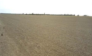
Location: Murtoa
Morphological Soil Type: Murtoa Clay
Australian Soil Classification: Episodic-Endocalcareous, Massive, Grey VERTOSOL
Northcote Factual Key: Ug 5.24
Great Soil Group: grey clay
Mapping Unit: Murtoa Clay.
General Landscape Description: Level plain.
Site Description: The site was cleared and cultivated.
Geology: Late Pleistocene to Holocene.
Native Vegetation: This site may have been within the savanna woodland Black Box (Eucalyptus largiflorens) association vegetation unit.
 IS13 landscape |
Soil Profile Morphology:
Surface Soil
| A1 | 0-10 cm | Greyish brown (10YR5/2); light clay; subplastic; surface cracking; massive surface condition when undisturbed; weak coarse subangular blocky structure when disturbed; very strong consistence dry, slightly sticky consistence wet; pH 7.3; sharp and wavy change to: | 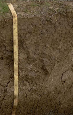 IS13 Profile |
| Subsoil | |||
| B21 | 10-25 cm | Greyish brown (10YR5/2); light medium clay; subplastic; moderate very coarse prismatic structure; strong consistence dry, slightly sticky consistence wet; pH 8.3: | |
| B22 | 25-60 cm | Greyish brown (10YR5/2); medium heavy clay; plastic; moderate very coarse prismatic structure; strong consistence dry, slightly sticky consistence wet; pH 8.9; sharp and wavy change to: | |
| B31 | 60-90 cm | Pale brown (10YR6/3); heavy clay; plastic; contains large slickensides; strong consistence dry, slightly sticky consistence wet; contains very few (< 2 %) soft and hard carbonates; pH 9.2: | |
| B32 | 90-120 cm | Pale brown (10YR6/3); heavy clay; plastic; contains large slickensides; strong consistence dry, slightly sticky consistence wet; contains very few (< 2 %) soft and hard carbonates; pH 9.1: | |
| B33 | 120-150 cm | Pale brown (10YR6/3); heavy clay; plastic; contains large slickensides; strong consistence dry, slightly sticky consistence wet; contains very few (< 2%) soft and hard carbonates; pH 8.7. | |
Key Profile Features:
- High clay content throughout soil profile.
- Vertic properties (ie. significant shrink-swell characteristic).
pH | Salinity Rating | |||
Surface (A1 horizon) | Slightly Alkaline | Very low | Sodic | None1 |
Subsoil (B21 horizon) | Moderately Alkaline | Very low | Sodic | Slight |
Deeper Subsoil (at 1 m) | Very Strongly Alkaline | Medium | Very Strongly Sodic | Strong |
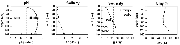
| The surface soil is slightly alkaline. The upper subsoil is moderately alkaline becoming very strongly alkaline with depth. | The salinity rating is very low in the surface and upper subsoil becoming moderate with depth. | The surface and upper subsoil is sodic becoming very strongly sodic with depth. | The clay content is high throughout the profile. |
Horizon | Sample Depth cm | pH | EC dS/m | Sodium Chloride % | Exchangeable Calcium cmol-/kg | Exchangeable Magnesium cmol-/kg | Exchangeable Potassium cmol-/kg | Exchangeable Sodium cmol-/kg | Exchangeable Aluminium mg/kg | Exchangeable Acidity cmol-/kg | Field Capacity -30okPa | Permanent Wilting Point -1500okPa | Coarse Sand % | Fine Sand % | Silt % | Clay % | |
H2O | CaCl2 | ||||||||||||||||
A1 | 010 | 7.3 | NA | 0.13 | 0.02 | 8.5 | 8.5 | 1.6 | 1.6 | NA | 3.1 | 28.5 | 18.8 | 8 | 27 | 10 | 52 |
B21 | 1025 | 8.3 | NA | 0.12 | 0.02 | 10.3 | 11.2 | 1.4 | 2.7 | NA | 2.2 | NA | 22.9 | 6 | 21 | 12 | 61 |
B22 | 25–60 | 8.9 | NA | 0.15 | 0.03 | 9.6 | 12.1 | 1.4 | 4 | NA | 3.3 | NA | 21.6 | 5 | 22 | 12 | 60 |
B31 | 60–90 | 9.2 | NA | 0.28 | 0.04 | 7.4 | 11.3 | 1.3 | 5.5 | NA | NA | NA | 20.0 | 6 | 25 | 11 | 55 |
B32 | 90–120 | 9.1 | NA | 0.58 | 0.08 | 6.9 | 11.8 | 1.4 | 7.3 | NA | NA | NA | 20.6 | 6 | 23 | 12 | 57 |
B33 | 120–150+ | 8.7 | NA | 0.92 | 0.17 | NA | NA | NA | NA | NA | NA | NA | 24.9 | 3 | 11 | 13 | 72 |
Management Considerations:
Whole Profile
- Plant available water capacity (PAWC) is considered to be very low (estimated at 40 mm). This is based on available laboratory data and assumes an effective rooting depth of 20 cm. Effective rooting depth has been observed in the field to be shallow due to the dense subsoil.
- The surface soil is sodic and disperses significantly after remoulding. This indicates that tillage or over-stocking of the soil whilst in a moist to wet condition may result in structural degradation (eg. surface sealing, increased cloddiness) occurring. Raindrop action on bare soil may have a similar effect, so it is important to maintain surface cover. Gypsum application may assist in improving surface soil structural condition on such soils.
- Tillage of cracking clay soils should be avoided if the soil is wet (ie. wetter than the plastic limit). At such a moisture condition, excessive tillage, trafficking or overstocking could result in structural damage (eg. compaction, smearing) occurring below the soil surface. Ideally, tillage and trafficking should take place when the soil is drier than the plastic limit, down to at least the tillage depth.
- The coarsely structured upper subsoil is sodic and has a low exchangeable calcium to magnesium ratio (ie. < 1). These conditions will result in some restrictions to root and water movement in the subsoil. The deeper subsoil (from 60 cm depth) becomes strongly sodic and dispersive. The level of exchangeable magnesium relative to calcium also increases. Water and root movement is likely to be significantly restricted in the deeper subsoil.
- The subsoil from 25 cm depth becomes strongly alkaline. This indicates that some nutrients (eg. manganese, zinc, iron, copper) may be poorly available to plants at depth. Plants will therefore rely on the surface soil for supply of these nutrients
- The level of soluble salts becomes medium in the deeper subsoil (from 90 cm depth). This may restrict the growth of deeper rooted salt sensitive species.
- The subsoil displays strong vertic properties (ie. slickenslides present) which indicate that significant shrinking and swelling occurs with wetting and drying cycles. This may disturb the roots of some plant species and has engineering implications (ie. disturbances to building foundations and fencelines).
Profile Described By: John Martin, Nabil Badawy, Ron Cawood, Geoff Pope, John Galea, John Turner (1970).
Reference: "Major Agricultural Soils of the Wimmera Irrigation Area". John Martin, Mark Imhof, Lourey Ruth, Rob Nink, Karen DePlater, Paul Rampant, Sonia Thompson, S. Alexander. Department of Natural Resources and Environment, Victoria. 1996.