Victorian Resources Online (archived)
Site IS17
Location: Horsham
Morphological Soil Type: Horsham Clay
Australian Soil Classification: Endohypersodic, Epipedal, Grey VERTOSOL
Northcote Factual Key: Ug 5.24
Great Soil Group: grey clay
Mapping Unit: Horsham Clay.
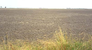
General Landscape Description: Level area in the flood plain (prior stream).
Site Description: The site was cleared and cultivated and occurs five kilometres east of Horsham in the original 'Youngs' and 'Riverside' Irrigation areas.
Geology: Late Tertiary to Quaternary Shepparton Formation.
Native Vegetation: Original vegetation may have been dominated by a Grey Box (Eucalyptus microcarpa) savanna woodland.
 IS17 Landscape |
Soil Profile Morphology:
Surface Soil
| A1 | 0-10 cm | Dark grey (10YR4/1); light clay; subplastic; cracking and slightly self-mulching surface condition; moderate subangular blocky structure; strong consistence dry, slightly sticky consistence wet; contains very few (< 2 %) soft carbonates; pH 7.3; sharp and smooth change to: | 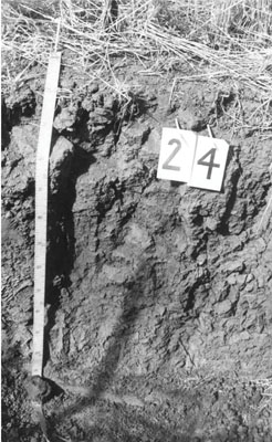 IS17 Profile |
| Subsoil | |||
| B21 | 10-55 cm | Dark grey (10YR4/1); light clay; subplastic; moderate very coarse prismatic structure; strong consistence dry, moderately sticky consistence wet; pH 7.6; gradual change to: | |
| B22 | 55-115 cm | Grey (2.5Y5/1); medium clay; plastic; weak subangular blocky structure; strong consistence dry, moderately sticky consistence wet; pH 7.6; gradual change to: | |
| B23 | 115-180 cm | Light grey (2.5Y7/2); medium clay; plastic; weak subangular blocky structure; strong consistence dry, moderately sticky consistence wet; pH 8.5. | |
Key Profile Features:
- High clay content throughout soil profile.
- Vertic properties (ie. significant shrink-swell characteristic).
Soil Profile Characteristics:
pH | Salinity Rating | |||
Surface (A1 horizon) | Slightly Alkaline | Low | Non-Sodic | None |
Subsoil (B21 horizon) | Slightly Alkaline | High | Sodic | None1 |
Deeper Subsoil (at 1 m) | Slightly Alkaline | Very High | Strongly Sodic | None1 |
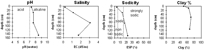
| The profile is slightly alkaline throughout. | The salinity rating is low in the surface. The subsoil is high becoming very high with depth. | The surface is non-sodic. The upper subsoil is sodic becoming strongly sodic with depth. | The clay content is high throughout the profile. |
Horizon | Sample Depth cm | pH | EC dS/m | Sodium Chloride % | Exchangeable Calcium cmol-/kg | Exchangeable Magnesium cmol-/kg | Exchangeable Potassium cmol-/kg | Exchangeable Sodium cmol-/kg | Exchangeable Aluminium mg/kg | Exchangeable Acidity cmol-/kg | Field Capacity -30okPa | Permanent Wilting Point -1500okPa | Coarse Sand % | Fine Sand % | Silt % | Clay % | |
H2O | CaCl2 | ||||||||||||||||
A1 | 0–10 | 7.3 | NA | 0.19 | 0.04 | 13.2 | 8.4 | 1.9 | 0.9 | NA | 5.2 | 31.4 | 16.6 | 10 | 26 | 14 | 50 |
B21 | 10–55 | 7.6 | NA | 1.11 | 0.2 | 12.1 | 13.9 | 1.6 | 4.2 | NA | 4.9 | NA | 25.1 | 5 | 14 | 15 | 64 |
B22 | 55–115 | 7.6 | NA | 3.06 | 0.7 | 11.4 | 17.4 | 1.7 | 6.4 | NA | 3 | NA | 28.1 | 3 | 10 | 14 | 71 |
B23 | 115–180 | 8.5 | NA | 1.72 | 0.39 | 10.3 | 16.1 | 1.8 | 8.2 | NA | 1.8 | NA | 32.1 | 4 | 15 | 10 | 67 |
Management Considerations:
Whole Profile
- Plant available water capacity (PAWC) is considered to be low (estimated at 55 mm). This is based on available laboratory data and assumes an effective rooting depth of 30 cm. Effective rooting depth will be restricted by the high level of soluble salts in the subsoil.
- When the soil is dry, heavy rains will move down soil cracks. This rapid recharge can be valuable for the survival of plants near wilting. When wet, the soil will swell and further infiltration of water will be relatively slow.
- Tillage of cracking clay soils should be avoided if the soil is wet (ie. wetter than the plastic limit). At such a moisture condition, excessive tillage, trafficking or overstocking can result in structural degradation (eg. compaction, smearing) occurring. Ideally, tillage should take place on clay soils such as these when the soil is drier than the plastic limit, down to at least the tillage depth.
- The level of soluble salts is high in the upper subsoil and becomes very high from 55 cm depth. These levels of soluble salts are likely to significantly restrict the growth of a number of plant species (eg. faba beans, chickpeas, lupins).
Profile Described By: John Martin, Nabil Badawy, Ron Cawood, Geoff Pope, John Galea, John Turner (1970).
Reference: "Major Agricultural Soils of the Wimmera Irrigation Area". John Martin, Mark Imhof, Lourey Ruth, Rob Nink, Karen DePlater, Paul Rampant, Sonia Thompson, S. Alexander. Department of Natural Resources and Environment, Victoria. 1996.