Site IS8
Location: Murtoa
Morphological Soil Type: Kalkee Clay
Australian Soil Classification: Epicalcareous-Endohypersodic, Self-mulching, Grey VERTOSOL
Northcote Factual Key: Ug5.25
Great Soil Group: grey clay
Mapping Unit: Kalkee Clay.
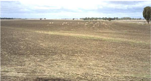
General Landscape Description: Mid-slope of a long gentle hillslope slope on the gently undulating plains landscape.
Site Description: The site was cleared and cultivated and lies two kilometres north east of Murtoa.
Geology: Quaternary aeolian and alluvial deposits (Shepparton Formation) overlying Tertiary (late Miocene to Pliocene) deposits.
Native Vegetation: Original vegetation may have been the grassland formation with a Spear Grass (Stipa species) and Wallaby Grass (Danthonia species) association.
 IS8 Landscape |
Soil Profile Morphology:
Surface Soil
| A1 | 0-5 cm | Dark greyish brown (10YR4/2); light clay; subplastic; cracking and self-mulching surface condition; moderate granular structure; weak consistence dry; contains very few (< 2 %) hard carbonates; pH 8.6; sharp and wavy change to: | 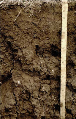 IS8 Profile |
| Subsoil | |||
| B21 | 5-25 cm | Dark greyish brown (10YR4/2); light medium clay; plastic; moderate very coarse prismatic structure; strong consistence dry, slightly sticky consistence wet; contains very few (< 2 %) hard carbonate; pH 9.1: | |
| B22 | 25-60 cm | Dark greyish brown (10YR4/2); heavy clay; plastic; moderate very coarse prismatic structure; strong consistence dry, slightly sticky consistence wet; contains very few (< 2 %) hard carbonates; pH 9.3: | |
| B23 | 60-85 cm | Greyish brown (10YR5/2); heavy clay; plastic; weak, very coarse subangular blocky structure; slickensides present; strong consistence dry, slightly sticky consistence wet; contains very few (< 2 %) hard carbonates; pH 9.3: | |
| B24 | 85-120 cm | Greyish brown (10YR5/2); heavy clay; plastic; weak, very coarse subangular blocky structure; slickensides present; strong consistence dry, slightly sticky consistence wet; contains very few (< 2 %) hard carbonates; pH 9.2; sharp and wavy change to: | |
| B31 | 120-150 cm | Brown (7.5YR5/4); medium clay; plastic; contains large slickensides; strong consistence dry, slightly sticky consistence wet; contains very few (< 2 %) hard and soft carbonates; pH 9.1: | |
| B32 | 150-175 cm | Yellowish red (5YR5/6); medium clay; plastic; contains large slickensides; strong consistence dry, slightly sticky consistence wet; contains very few (< 2 %) hard and soft carbonates; pH 8.9. | |
Key Profile Features:
- Self-mulching surface soil.
- High clay content throughout profile.
- Vertic properties (ie. significant shrink-swell characteristic).
- Calcareous profile throughout.
- Variable subsoil properties related to gilgai microrelief.
Soil Profile Characteristics:
pH | Salinity Rating | |||
Surface (A1 horizon) | Strongly Alkaline | Low | Non-Sodic | None |
Subsoil (B21 horizon) | Very Strongly Alkaline | Low | Sodic | Slight |
Deeper Subsoil (at 1 m) | Very Strongly Alkaline | Medium | Very Strongly Sodic | Slight |
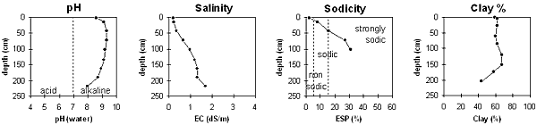
| The surface soil is strongly alkaline. The subsoil is very strongly alkaline throughout. | The salinity rating is low in the surface and upper subsoil becoming moderate with depth. | The surface is non-sodic. The upper subsoil is sodic becoming very strongly sodic with depth. | The clay content is high throughout the profile. |
Horizon | Sample Depth cm | pH | EC dS/m | Sodium Chloride % | Exchangeable Calcium cmol-/kg | Exchangeable Magnesium cmol-/kg | Exchangeable Potassium cmol-/kg | Exchangeable Sodium cmol-/kg | Exchangeable Aluminium mg/kg | Exchangeable Acidity cmol-/kg | Field Capacity -30okPa | Permanent Wilting Point -1500okPa | Coarse Sand % | Fine Sand % | Silt % | Clay % | |
H2O | CaCl2 | ||||||||||||||||
A1 | 0–5 | 8.6 | NA | 0.18 | 0.02 | 28.4 | 6.8 | 2.3 | 0.9 | NA | 1.6 | 37.7 | 23.0 | 12 | 14 | 8 | 59 |
B21 | 5–25 | 9.1 | NA | 0.21 | 0.01 | 26.3 | 9.8 | 1.6 | 3.2 | NA | NA | 42 | 25.1 | 10 | 13 | 7 | 62 |
B22 | 25–60 | 9.3 | NA | 0.35 | 0.02 | 22.8 | 11.1 | 1.6 | 6.6 | NA | NA | NA | 27.6 | 9 | 12 | 8 | 62 |
B23 | 60–85 | 9.3 | NA | 0.66 | 0.11 | 16.7 | 12.4 | 1.6 | 11.6 | NA | NA | NA | 30.3 | 8 | 14 | 10 | 60 |
B24 | 85–120 | 9.2 | NA | 0.98 | 0.1 | 14.9 | 12 | 1.7 | 12.9 | NA | NA | NA | 31.8 | 7 | 13 | 9 | 62 |
B31 | 120–150 | 9.1 | NA | 1.2 | 0.12 | NA | NA | NA | NA | NA | NA | NA | 30.0 | 7 | 13 | 9 | 67 |
B32 | 150–175 | 8.9 | NA | 1.3 | 0.13 | NA | NA | NA | NA | NA | NA | NA | 29.4 | 9 | 11 | 11 | 67 |
B33 | 175–205 | 8.7 | NA | 1.3 | 0.13 | NA | NA | NA | NA | NA | NA | NA | 25.0 | 20 | 11 | 9 | 58 |
B34 | 205–230 | 8.0 | NA | 1.69 | 0.1 | NA | NA | NA | NA | NA | NA | NA | NA | 37 | 13 | 6 | 44 |
Management Considerations:
Whole Profile
- Plant available water capacity (PAWC) is considered to be relatively medium (estimated at 105 mm). This is based on available laboratory data and assumes an effective rooting depth of 60 cm. Rooting depth will be restricted by the strongly sodic deeper subsoil and increasing level of soluble salts. The availability of moisture to the plant will depend on soil structure and consistence and will be most available in the more friable surface horizon. In dense and coarsely structured subsoils it is likely that there will be a large amount of unused ‘available’ moisture at depth in the subsoil.
- The strongly alkaline profile suggests that some nutrients (eg. iron, manganese, zinc, copper) may be poorly available to plants and that deficiencies are likely to occur. Deficiencies can be determined by plant tissue analysis. The high alkalinity of the soil profile will reduce the potential of the soil to support some crops (eg. lupins).
- The surface soil is self-mulching which provides an ideal seed bed. In the dry to moist stage, these soils are friable and easy to work but become sticky when wet. Crop establishment is promoted on friable surface soils compared to non-friable soil. Badawy (1981) notes, however, that cereal crops grown on friable clays are more prone to cereal cyst nematode.
- When the soil is dry, heavy rains will move down soil cracks. This rapid recharge can be valuable for the survival of plants near wilting. When wet, the soil will swell and further infiltration will be relatively slow. After heavy rains, water can lie for long periods in the deeper gilgai depressions.
- The high wilting point value (ie. 23%) indicates that plants will be unable to utilise light rains when the soil is relatively dry.
- This soil has a high cation exchange capacity with relatively high levels of exchangeable calcium and potassium. These soils tend to mineralise nitrogen readily in cultivated bare fallows and initially produce high yields but total nitrogen levels diminish rapidly with cropping. On similar soils in the Wimmera, legumes (including subterranean clover) often respond to additions of zinc, molybdenum, manganese, sulphur and phosphorus. Cereals respond to additions of phosphorus and zinc (Badawy 1981).
- Tillage of cracking clay soils should be avoided if the soil is wet (ie. wetter than the plastic limit). At such moisture conditions, excessive tillage, trafficking or over-stocking could result in structural damage (eg. compaction, smearing occurring). Ideally, tillage should take place on clay soils such as these when the soil is drier than the plastic limit, down to at least the tillage depth.
- The upper subsoil is sodic but does not disperse. As a result, root and water movement into the subsoil may not be as restricted as for other soils with strongly dispersive subsoils. The high levels of exchangeable calcium will contribute to reducing dispersion. The calcium to magnesium ratio is still relatively high (2.6) in the upper subsoil.
- The deeper subsoil (from 60 cm depth) becomes strongly sodic and root and water movement is likely to be restricted at depth. The high level of exchangeable sodium in the subsoil may also result in nutrient imbalances and may even have a toxic effect on some plants. The levels of exchangeable magnesium also increase in the deeper subsoil resulting in a much reduced calcium to magnesium ratio.
- The salinity rating becomes medium at 85 cm depth. This may restrict the growth of deeper-rooted salt sensitive species.
- The subsoil displays strong vertic properties which indicates that significant shrinking and swelling occurs with wetting and drying cycles. This may disturb the roots of some plant species and has engineering implications (eg. disturbance to building foundations and fencelines).
- The original gilgai microrelief is caused due to the vertic properties of the soil and resultant shrinking and swelling with alternate wetting and drying. This forces ‘blocks’ of soil material gradually upward to form mounds (or ‘puffs’). The soil on the mounds will be different to soils on the depressions. Mound soils tend to be lighter in colour and have higher carbonate contents. Salinity can also often be higher in the upper soil profile on the mounds. Continuous cultivation has resulted in the smoothing out of many of these gilgai formations. The forces that created them, however, are still operating as is evident by the displacement of fence posts; and if the land is left undisturbed over a number of wetting and drying seasons they will reform. In areas with gilgai microrelief, crop and pasture growth is likely to be uneven across a paddock due to soil variations and poor drainage conditions in depressions. Levelling of gilgais can reduce the depth of surface soil on gilgai mounds which may expose the subsoils.
Profile Described By: John Martin, Nabil Badawy, Ron Cawood, Geoff Pope, John Galea, John Turner (1970).
Reference: "Major Agricultural Soils of the Wimmera Irrigation Area". John Martin, Mark Imhof, Lourey Ruth, Rob Nink, Karen DePlater, Paul Rampant, Sonia Thompson, S. Alexander. Department of Natural Resources and Environment, Victoria. 1996.