Site IS32
Location: Vectis South
Soil Type: Norton Sandy Clay
Australian Soil Classification: Vertic, Calcic, Grey CHROMOSOL
Northcote Factual Key: Dy 2.33
Great Soil Group: solonetz
Mapping Unit: Norton Sandy Clay.
General Landscape Description: Level area on the swale component of the dune and swale landscape.
Site Description: The site was cleared and under pasture at time of soil survey. The site lies twelve kilometres south west of Horsham in the Quantong area.
Geology: Late Tertiary to Quaternary. Quaternary Shepparton Formation: fluvial silt, sand and minor gravel
Native Vegetation: Probable original vegetation was the Grey Box (Eucalyptus microcarpa), Buloke (C. luehmannii) and Yellow Gum (E. leucoxylon) tall woodland formation.
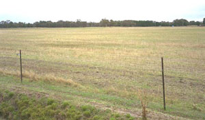 IS32 Landscape - Swale between dunes near Quantong. |
Soil Profile Morphology:
Surface Soil
| A1 | 0-10 cm | Very dark greyish brown (10YR3/2); sandy clay loam; plastic; hardsetting surface condition; weak subangular blocky structure; strong consistence dry, sticky consistence wet; pH 7.1; sharp change to: | 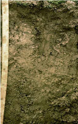 IS32 Profile |
| Subsoil | |||
| B21 | 10-20 cm | Greyish brown (2.5Y5/2); medium clay; plastic; weak very coarse prismatic structure; strong consistence dry, sticky consistence wet; pH 7.6; diffuse change to: | |
| B22 | 20-40 cm | Greyish brown (2.5Y5/2) sporadically bleached (10YR7/3); light clay; subplastic; weak very coarse prismatic structure; strong consistence dry, sticky consistence wet; pH 8.3; sharp change to: | |
| B31 | 40-65 cm | Olive (5Y5/6) with pale brown (10YR6/3) mottles; heavy clay; plastic; contains large slickensides; strong consistence dry; contains very few (< 2 %) soft carbonates; pH 9.3: | |
| B32 | 65-80 cm | Olive (5Y5/6) with pale brown (10YR6/3) mottles; heavy clay; plastic; contains large slickensides; strong consistence dry, sticky consistence wet; contains very few (< 2 %) soft carbonates; pH 9.4; gradual change to: | |
| B33 | 80-100 cm | Strong brown (7.5YR5/6); heavy clay; moderate very coarse structure with slickensides; strong consistence dry; contains very few (< 2 %) hard carbonates and a common (10-20 %) amount of soft carbonate; pH 9.4: | |
| B34 | 100-150 cm | Strong brown (7.5YR5/6); heavy clay; moderate very coarse structure with slickensides; strong consistence dry; pH 9.3; sharp change to: | |
| B41 | 150-180 cm | Pale yellow (5Y7/3); medium clay (sandy); moderate very coarse structure with slickensides; strong consistence dry; contains a few (2-10 %) soft carbonates; pH 9.6: | |
| B42 | 180-215 cm | Pale yellow (5Y7/3); medium clay (sandy); moderate very coarse structure with slickensides; strong consistence dry; contains very few (< 2 %) soft carbonates; pH 9.4: | |
- Strong texture contrast between surface (A) horizon (21% clay) and subsoil (B21) horizon (43% clay).
- Vertic properties (ie. slickensides present) in deeper subsoil.
Soil Profile Characteristics:
pH | Salinity Rating | |||
Surface (A1 horizon) | Slightly Alkaline | Low | Non-Sodic | None |
Subsoil (B21 horizon) | Slightly Alkaline | Very Low | Non-Sodic | None |
Deeper Subsoil (at 1 m) | Very Strongly Alkaline | High | Very Strongly Sodic | - |
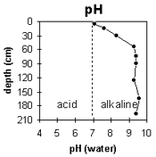 |  | 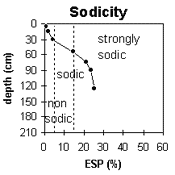 | 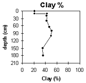 |
| The surface and upper subsoil is slightly alkaline. The deeper subsoil is very strongly alkaline. | The salinity rating is low in the surface. The upper subsoil is very low becoming high with depth. | The surface is non-sodic. The upper subsoil is non-sodic becoming very strongly sodic with depth. | The clay content increases markedly at the surface / subsoil boundary. |
Horizon | Sample Depth cm | pH | EC dS/m | Sodium Chloride % | Exchangeable Calcium cmol-/kg | Exchangeable Magnesium cmol-/kg | Exchangeable Potassium cmol-/kg | Exchangeable Sodium cmol-/kg | Exchangeable Aluminium mg/kg | Exchangeable Acidity cmol-/kg | Field Capacity -30okPa | Permanent Wilting Point -1500okPa | Coarse Sand % | Fine Sand % | Silt % | Clay % | |
H2O | CaCl2 | ||||||||||||||||
A1 | 0–10 | 7.1 | NA | 0.09 | 0.01 | 5.5 | 3.2 | 1 | 0.1 | NA | 4.2 | 13 | 9.3 | 39 | 32 | 6 | 21 |
B21 | 10–20 | 7.6 | NA | 0.11 | 0.01 | 10 | 7.8 | 1.4 | 0.4 | NA | 4.5 | NA | 17.2 | 28 | 24 | 5 | 43 |
B22 | 20–40 | 8.3 | NA | 0.17 | 0.01 | 10.4 | 8.8 | 1.3 | 0.9 | NA | 3 | NA | 18.2 | 26 | 25 | 4 | 42 |
B31 | 40–65 | 9.3 | NA | 0.34 | 0.04 | 7.7 | 10.9 | 1.3 | 3.4 | NA | 0.9 | NA | 18.6 | 25 | 27 | 3 | 42 |
B32 | 65–80 | 9.4 | NA | 0.57 | 0.08 | 6.8 | 13.7 | 1.3 | 5.8 | NA | NA | NA | 22.6 | 23 | 23 | 4 | 47 |
B33 | 80–100 | 9.4 | NA | 0.77 | 0.1 | 6.4 | 15.3 | 1.7 | 7.2 | NA | NA | NA | 23.7 | 19 | 18 | 3 | 51 |
B34 | 100–150 | 9.3 | NA | 0.9 | 0.14 | 5.4 | 15.5 | 1.5 | 7.6 | NA | NA | NA | 22.4 | 20 | 18 | 3 | 50 |
B41 | 150–180 | 9.6 | NA | 0.8 | 0.11 | NA | NA | NA | NA | NA | NA | NA | 16.3 | 29 | 25 | 3 | 35 |
B42 | 180–215 | 9.4 | NA | 0.86 | 0.13 | NA | NA | NA | NA | NA | NA | NA | 16.7 | 29 | 29 | 5 | 36 |
Management Considerations:
Whole Profile
- Plant available water capacity (PAWC) is considered to be low (estimated at 82 mm). This is based on available laboratory data and assumes an effective rooting depth of 65 cm. Rooting depth will be restricted by the strongly sodic deeper subsoil and the increase in soluble salt levels at depth. The deeper subsoil is also very strongly alkaline which will reduce the availability of certain nutrients.
- The surface soil is hardsetting and requires organic matter for maintaining soil aggregation. Organic matter levels will decline if cropping takes place and can be improved by adopting practices such as residue retention, minimum tillage and utilising pasture rotations.
- The upper subsoil is non-sodic and does not disperse. It is, however, weakly and coarsely structured which will restrict root movement. The deeper subsoil becomes strongly sodic from 50 cm depth and this will result in restricted root and water movement at depth. The deeper subsoil is also very strongly alkaline which will reduce the availability of certain nutrients.
- The deeper subsoil (from 50 cm depth) becomes very strongly alkaline which may restrict the growth of some plants. Some nutrients (eg. iron, manganese, copper, zinc) are also likely to be poorly available at depth.
- The subsoil displays vertic properties (ie. slickensides) which indicates that significant shrinking and swelling will occur during wetting and drying cycles. This will have implications for engineering purposes (eg. building foundations).
Profile Described By: John Martin, Nabil Badawy, Ron Cawood, Geoff Pope, John Galea, John Turner (1970).
Reference: "Major Agricultural Soils of the Wimmera Irrigation Area". John Martin, Mark Imhof, Lourey Ruth, Rob Nink, Karen DePlater, Paul Rampant, Sonia Thompson, S. Alexander. Department of Natural Resources and Environment, Victoria. 1996.