Victorian Resources Online (archived)
Site LS10
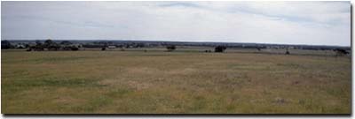
Location: Propodollah
Australian Soil Classification: Calcic, Mottled-Mesonatric, Yellow SODOSOL (sandy)
Northcote Factual Key: Dy 4.43
Great Soil Group: solodic/solodized solonetz(intermixed)
General Landscape Description: Mid slope of NNW/SSE trending ridge. Slope generally 3%. Susceptible to gully erosion (averaging 0.5 m deep, 5 m wide).
Native Vegetation: Supports Mallee vegetation when undisturbed.
 LS10 Landscape |
Soil Profile Morphology:
Surface Soil
| A1 | 0-10 cm | Brown (10YR4/3); loamy sand; weakly structured; weak consistence dry; contains very few (2 %) ferromanganiferous nodules; pH 6.3; sharp and wavy boundary change to: | 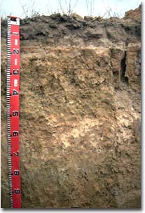 LS10 Profile |
| A2 | 10-15 cm | Discontinuous light yellowish brown (10YR6/4) conspicuously bleached; sand; structureless; loose consistence dry: | |
| Subsoil | |||
| B11 | 15-18 cm | Yellowish red (5YR5/6) and light yellowish brown (10YR6/4) mottles; sandy loam (clayey); structureless; very firm consistence moist; pH 7.7: | |
| B12 | 18-30 cm | Yellowish brown (10YR5/4) with strong brown (7.5YR5/8); light sandy clay loam; weak columnar structure; strong consistence moist; pH 8.1: | |
| B21 | 30-55 cm | Pale yellow (2.5YR7/4); light clay (sandy); moderate coarse blocky structure; very strong consistence moist; pH 8.8: | |
| B22 | 55-70 cm | Light brown (7.5YR6/4); medium clay (sandy); contains a common (10 - 20%) amount of soft calcareous segregations; pH 9.5: | |
| B23 | 70-90 cm | Brownish yellow (10YR6/5) with yellowish red mottles; light medium clay (sandy); contains a common (10 - 20%) amount of ironstone nodules; pH 9.2: | |
| B24 | 90-110 cm | Similar to above with more mottling: | |
| C | 110 cm+ | Weathered sandstone. |
Key Profile Features:
- Strong texture contrast between sandy surface horizons and clay subsoils.
- Conspicuously bleached subsurface (A2) horizon.
- Discontinuous presence of coarse columnar structure at the top of the subsoil.
Soil Profile Characteristics:
| - | pH | Salinity | ||
Surface (A1 horizon) | Slightly Acid | Very Low | Non-Sodic | None |
Subsoil (B21 horizon) | Strongly Alkaline | Low | Strongly Sodic | Strong |
Deeper Subsoil (at 1 metre) | Moderately Alkaline | High-Very high | Strongly Sodic | Strong |
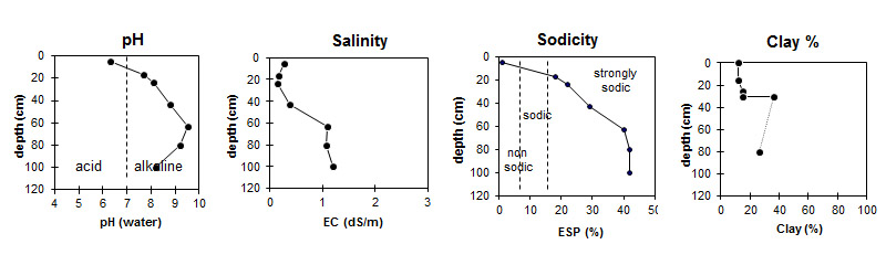
| The surface soil is slightly acid. The subsoil is strongly alkaline becoming very strongly alkaline at 70 cm depth, before dropping back to moderately alkaline. | The salinity rating is very low in the surface and low in the upper subsoil becoming high with depth. | The surface is non-sodic. The subsoil is strongly sodic. | There is a sharp increase in clay at the surface / subsoil boundary. |
Management Considerations:
Surface (A) Horizons
- The shallow surface horizon is prone to wind erosion. Its removal would expose the sodic and strongly dispersive subsoils to water erosion.
- The surface horizon has a very low inherent fertility as well as low levels of total nitrogen and organic carbon. Improved organic matter levels would assist in stabilisation of surface soil aggregates as well as improving fertility and water holding capacity.
- Plant available water capacity is limited by the sandy texture of the surface horizon and structural properties of the subsoil. The sandy surface horizons, however, have a low wilting point value (ie. 2 %) which means that plants will be able to utilise light rains falling on relatively dry soil. They will soon suffer moisture stress if further rains do not fall.
Subsoil (B) Horizons
- The dense and coarsely structured subsoil is strongly sodic and dispersive and will restrict water and root movement down the profile.
- The high levels of exchangeable sodium in the subsoil may also result in nutrient imbalances and may even have a toxic effect on some plants.
- The dispersive subsoil is highly erodible if exposed to raindrop impact. Maintaining a protective cover of surface soil and vegetation is important, especially on sloping land.
- Soluble salt levels become high in the deeper subsoil (from 55 cm depth).
Profile Described By: Mark Imhof, David Rees, Sonia Thompson (October 1994).