Victorian Resources Online (archived)
ALRA67
|
| ALRA67 | 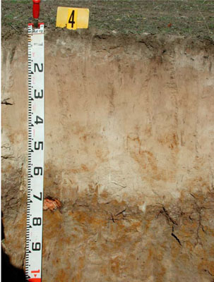 Eutrophic, Mottled-Subnatric, Grey Sodosol | |
|
Location | Moyston West Road | |||
|
Landform | Gently undulating plain | |||
|
Geology | Quaternary alluvium | |||
|
Element | Plain | |||
|
Slope | 1% | |||
|
Aspect | South | |||
Horizon | Depth (cm) | Description | ||
A1 | 0–5 | Dark greyish brown (7.5YR3/1); coarse sand; massive (structureless); very weak consistence when moderately moist; pH 6.5; clear and smooth boundary to: | ||
A21 | 5–30 | Light grey (10YR7/2); sporadically bleached (7.5YR6/3 dry); loamy sand; massive structure(structureless); very weak consistence when dry; pH 6.5; clear and wavy boundary to: | ||
A22 | 30–45 | Pinkish grey (7.5YR7/2); sporadically bleached (7.5YR7/3 dry); loamy sand; massive (structureless); weak consistence when moderately moist; pH 6.5; gradual and wavy boundary to: | ||
A23 | 45–60 | White (10YR8/2) with few coarse faint brownish yellow mottles; sporadically bleached (10YR7/3 dry); clay loam; massive (structureless); weak consistence when dry; pH 5.5; sharp and wavy boundary to: | ||
B21 | 60–75 | Greyish brown (10YR5/2) with many medium to coarse distinct brownish yellow (10YR6/6) mottles; medium clay, coarse sandy; moderate fine angular blocky structure; rough ped-fabric; firm to very firm consistence when moist; common prominent clay skins; pH 5.5; clear and wavy boundary to: | ||
B22 | 75–140+ | Greyish brown (2.5Y5/2) with many very coarse distinct yellowish brown (10YR5/6) mottles; light medium clay; weak medium subangular blocky structure; rough ped-fabric; weak consistence when moist; pH 7.0. | ||
| Management considerations | ||||
| ||||
Site ALRA67 | Sample depth cm | pH | EC dS/m | NaCl % | Organic Carbon % | Ex Ca cmol-/kg | Ex Mg cmol-/kg | Ex K cmol-/kg | Ex Na cmol-/kg | Ex Al cmol-/kg | Ex acidity cmol-/kg | FC -30okPa | PWP -1500okPa | KS % | FS % | Z % | C % | |
Horizon | H2O | CaCl2 | ||||||||||||||||
A1 | 0-5 | 5.6 | 5.2 | 0.18 | NA | 4.7 | 7.3 | 2.1 | 0.41 | 0.35 | <10 | 8.2 | 14 | 10.5 | 48.6 | 39.4 | 5.5 | 1.0 |
A21 | 5-30 | 5.9 | 5.5 | <0.05 | NA | NA | 0.58 | 0.16 | 0.05 | 0.05 | <10 | <1.0 | 4.7 | 0.6 | 48.8 | 43.5 | 7.0 | 0.5 |
A22 | 30-45 | 6.4 | 6.1 | <0.05 | NA | NA | 0.41 | 0.13 | <0.05 | 0.05 | <10 | <1.0 | 4.7 | 0.7 | 51.8 | 40.8 | 5.5 | 0 |
A23 | 45-60 | 6.2 | 5.8 | <0.05 | NA | NA | 0.23 | 0.12 | <0.05 | 0.06 | <10 | <1.0 | 4.2 | 0.4 | 46.3 | 43.0 | 8.5 | 1.0 |
B21 | 60-75 | 5.1 | 4.2 | 0.17 | NA | NA | 0.79 | 4 | 0.32 | 1.7 | 280 | 12 | 23.7 | 13.2 | 37.1 | 21.8 | 2.0 | 36.5 |
B22 | 75-140+ | 5.5 | 4.5 | 0.16 | NA | NA | 0.64 | 2.5 | 0.14 | 1.5 | 95 | 4.5 | 14.5 | 6.4 | 48.3 | 32.2 | 3.5 | 14.5 |
Note: NA=not assessed
Site ALRA67 | Sample depth cm | pH | EC dS/m | TSS % | P (Olsen) (mg/kg) | Total N & | Organic Carbon % | Organic matter % | |
Horizon | H2O | CaCl2 | |||||||
Bulk sample | 0–10 | 5.6 | 5.2 | 0.16 | 0.05 | 14 | 0.18 | 2.8 | 5.3 |