Victorian Resources Online (archived)
LSWW29
|
| LSWW29 | 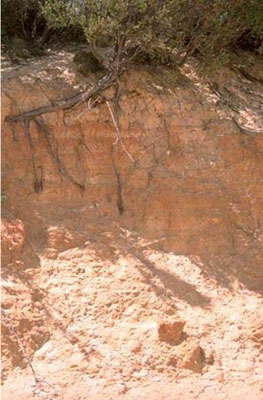 Basic, Argic, Yellow-Orthic Tenosol | |
|
Location | Chappel Road, Telopea Downs, western Victoria | |||
|
Landform | Dune | |||
|
Geology | Quaternary Lowan Formation: aeolian fine to medium grained dune sand | |||
|
Element | Dunecrest | |||
Horizon | Depth (cm) | Description | ||
A | 0–100 | Light yellowish brown (10YR6/4); sand with fine argic layers (sandy loam), 2–5 mm thick; pH 6.9. | ||
B | 100–200 | Brownish yellow (10YR6/6) with light grey and red mottles; sand with argic lines (clayey sand to sandy loam texture); pH 6.5. | ||
| Management considerations | ||||
| ||||
Site WW29 | Sample depth cm | pH | EC dS/m | NaCl % | Ex Ca cmol-/kg | Ex Mg cmol-/kg | Ex K cmol-/kg | Ex Na cmol-/kg | Ex Al mg/kg | Ex acidity cmol-/kg | FC -30okPa | PWP -1500okPa | KS % | FS % | Z % | C % | |
Horizon | H2O | CaCl2 | |||||||||||||||
A | 0–100 | 6.9 | 5.9 | <0.05 | NA | NA | NA | NA | NA | NA | NA | NA | NA | NA | NA | NA | NA |
B | 100–200 | 6.5 | 5.6 | 0.08 | NA | NA | NA | NA | NA | NA | NA | NA | NA | NA | NA | NA | NA |