Victorian Resources Online (archived)
ALRA69
|
| ALRA69 | 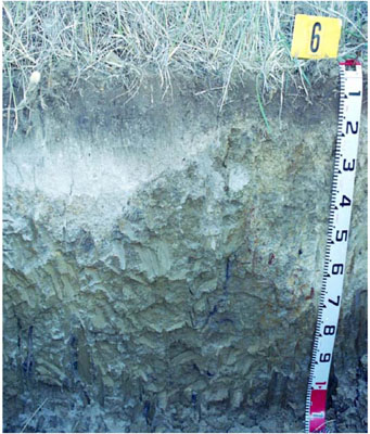 Vertic (& Ferric), Mottled-Hypernatric, Brown Sodosol | |
|
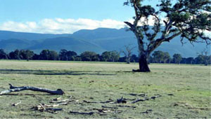
Location | Morass Road, Barton | |||
|
Landform | Gently undulating plain | |||
|
Geology | Quaternary Newer Volcanics: extrusive tholeitic to alkaline basalt, scoria and ash | |||
|
Element | Plain | |||
|
Slope | 1% | |||
|
Aspect | West | |||
Horizon | Depth (cm) | Description | ||
A1 | 0–15 | Dark brown (7.5YR3/2); clay loam; strong very fine subangular blocky structure; rough fabric; weak consistence when moderately moist; pH 5.5; gradual and smooth boundary to: | ||
A21 | 15–30 | Greyish brown(10YR5/2); sporadically bleached light grey (10YR7/2 moist); clay loam; massive (structureless); firm consistence when dry; pH 6.0; abrupt and wavy boundary to: | ||
A22 | 30–40 | Greyish brown (10YR5/2); sporadically bleached light grey (10YR7/2 moist); common fine distinct strong brown (7.5YR5/6) mottles; clay loam; weak medium size subangular blocky structure; rough fabric; strong consistence when dry; many fine and medium ferromanganiferous nodules; pH 6.5; clear and wavy boundary to: | ||
B21 | 40–70 | Light olive brown (2.5Y5/6) with common fine faint greyish brown (2.5Y5/2) and fine strong brown (7.5YR5/6) mottles; medium heavy clay; moderate coarse polyhedral structure; few medium manganiferous concretions; smooth fabric; few distinct slickensides; very firm consistence when moderately moist; pH 7.0; gradual and wavy boundary to: | ||
B22 | 70–110+ | Light olive brown (2.5Y5/4); medium heavy clay; moderate medium and coarse prismatic structure; smooth fabric; few distinct slickensides; very firm consistance when moderately moist; pH 7.0. | ||
| Management considerations | ||||
| ||||
Site ALRA69 | Sample depth cm | pH | EC dS/m | NaCl % | Organic Carbon % | Ex Ca cmol-/kg | Ex Mg cmol-/kg | Ex K cmol-/kg | Ex Na cmol-/kg | Ex Al cmol-/kg | Ex acidity cmol-/kg | FC -30okPa | PWP -1500okPa | KS % | FS % | Z % | C % | |
Horizon | H2O | CaCl2 | ||||||||||||||||
A1 | 0-15 | 5.5 | 4.9 | 0.1 | NA | 3.0 | 3.4 | 1.7 | 0.27 | 0.51 | <10 | NA | 27.7 | 7.2 | 9.4 | 48.7 | 21.0 | 12.5 |
A21 | 15-30 | 6.0 | 5.4 | 0.08 | NA | NA | 1.7 | 0.68 | 0.05 | 0.37 | <10 | NA | 23.9 | 2.7 | 9.7 | 58.1 | 23.5 | 6.0 |
A22 | 30-40 | 7.3 | 6.6 | 0.13 | NA | NA | 1.8 | 2.8 | 0.1 | 1.2 | <10 | NA | 19.7 | 7.3 | 17.1 | 47.2 | 17.5 | 14.0 |
B21 | 40-70 | 7.4 | 6.9 | 0.55 | NA | NA | 3.6 | 12 | 0.2 | 5.6 | NA | NA | 46.6 | 24.3 | 7.9 | 19.0 | 9.5 | 60.5 |
B22 | 70-110+ | 7.1 | 6.7 | 1.0 | NA | NA | 2.9 | 15 | 0.2 | 7.5 | NA | NA | 48.2 | 23.6 | 3.9 | 16.2 | 15.0 | 59.0 |
Note: NA=not assessed