Victorian Resources Online (archived)
ALRA81
|
| ALRA81 | 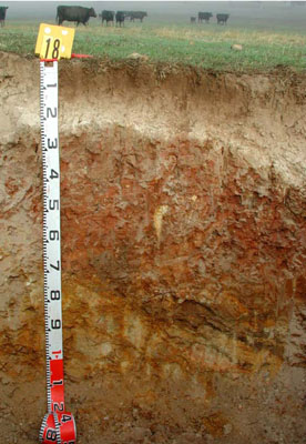 | |
|
Location | Jallukar Hills, Jallukar | |||
|
Landform | Rolling hills | |||
|
Geology | Cambrian volcanics | |||
|
Element | Hillslope | |||
|
Slope | 12% | |||
|
Aspect | West | |||
Horizon | Depth (cm) | Description | ||
A1 | 0–10 | Very dark greyish brown (10YR3/2); sandy loam; very fine moderate subangular blocky structure; rough-ped fabric; weak to very weak consistence when dry; water repellent; common fine to medium angular/subangular/subrounded metamorphic; sedimentary and quartz coarse fragments; pH 5.5; clear and smooth boundary to: | ||
A2 | 10–20 | Brown (7.5YR4/4); sporadically bleached (10YR8/2); clayey sand (coarse sandy); massive structure; rough-ped fabric; weak consistence when dry; many (50%) fine to medium gravelly subangular and subrounded metamorphic and sedimentary coarse fragments; pH 6.5; abrupt and wavy boundary to: | ||
B2 | 20–60 | Yellowish red (5YR4/6) with common medium distinct light olive brown (2.5Y5/4) mottles; medium heavy clay; moderate medium to coarse angular blocky structure; rough and smooth-ped fabric; very firm consistence when moderately moist; few fine to medium gravelly angular; subangular and subrounded metamorphic and sedimentary coarse fragments; pH 8.0; diffuse and irregular boundary to: | ||
B3 | 60–70 | Yellowish red (5YR4/6); medium clay; strong fine angular blocky structure; smooth-ped fabric; firm consistence when moderately moist; many (50%) fine medium to coarse angular; subangular and subrounded metamorphic and sedimentary coarse fragments; pH 8.0; sharp and irregular boundary to: | ||
C | 70+ | Consolidated bedrock. | ||
| Management considerations | ||||
| ||||
Site ALRA81 | Sample depth cm | pH | EC dS/m | NaCl % | Organic Carbon % | Ex Ca cmol-/kg | Ex Mg cmol-/kg | Ex K cmol-/kg | Ex Na cmol-/kg | Ex Al cmol-/kg | Ex acidity cmol-/kg | FC -30okPa | PWP -1500okPa | KS % | FS % | Z % | C % | |
Horizon | H2O | CaCl2 | ||||||||||||||||
A1 | 0–10 | 5.5 | 4.9 | 0.25 | NA | 3.6 | 3.5 | 1.4 | 1.2 | 0.79 | <10 | 9.1 | 20.8 | 8.0 | 21.9 | 45.1 | 13.5 | 9.5 |
A2 | 10–20 | 6.9 | 6.5 | 0.09 | NA | NA | 2.3 | 1.2 | 0.49 | 0.44 | NA | 2.9 | 16.5 | 9.1 | 24.6 | 48.0 | 15.0 | 7.0 |
B2 | 20–60 | 7.5 | 6.7 | 0.27 | 0.04 | NA | 5.4 | 14.0 | 0.9 | 3.4 | NA | NA | 37.5 | 19.8 | 9.7 | 25.8 | 11.5 | 51.5 |
B3 | 60–70 | 7.7 | 6.9 | 0.4 | 0.06 | NA | 4.5 | 11.0 | 0.7 | 4.3 | NA | NA | 32.9 | 16.1 | NA | NA | NA | NA |
Note: NA=not assessed