Victorian Resources Online (archived)
LS10
|
| LS10 | 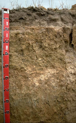 Calcic, Mottled-Mesonatric, Yellow Sodosol (sandy) | |
|
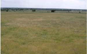
Location | Propodollah Ridge, western Victoria | |||
|
Landform | Ridge | |||
|
Geology | Pliocene Parilla Sand: marine sand and silt | |||
|
Element | Hillslope (middle) | |||
|
Slope | 3% | |||
|
Aspect | North-east | |||
Horizon | Depth (cm) | Description | ||
A1 | 0–10 | Brown (10YR4/3) loamy sand; weakly structured; weak consistence (dry); contains very few (2%) ferromanganiferous nodules; pH 6.3; sharp and wavy boundary to: | ||
A2 | 10–15 | Discontinuous light yellowish brown (10YR6/4) conspicuously bleached sand; single grained (structureless); loose consistence (dry). | ||
B11 | 15–18 | Yellowish red (5YR5/6) and (10YR6/4) mottles; sandy loam (clayey); single grained (structureless), very firm consistence (moist); pH 7.7. | ||
B12 | 18–30 | Yellowish brown (10YR5/4) with (7.5YR5/8) mottles; light sandy clay loam; single grained (structureless), strong consistence (moist); pH 8.1. | ||
B21 | 30–55 | Pale yellow (2.5YR7/4) light clay (sandy); moderate coarse blocky structure; very strong consistence (moist); pH 8.8. | ||
B22 | 55–70 | Light brown (7.5YR6/4) medium clay (sandy); contains a common (10–20%) amount of soft calcareous segregations; pH 9.5. | ||
B23 | 70–90 | Brownish yellow (10YR6/5) with yellowish red mottles; light medium clay (sandy); contains a common (10–20%) amount of ferruginous nodules; pH 9.2. | ||
B24 | 90–110 | Similar to above with more mottling | ||
C | 110+ | Weathered sandstone. | ||
| Management considerations | ||||
| ||||
Site LS10 | Sample depth cm | pH | EC dS/m | NaCl % | Ex Ca cmol-/kg | Ex Mg cmol-/kg | Ex K cmol-/kg | Ex Na cmol-/kg | Ex Al mg/kg | Ex acidity cmol-/kg | FC -30okPa | PWP -1500okPa | KS % | FS % | Z % | C % | |
Horizon | H2O | CaCl2 | |||||||||||||||
A1 | 0–10 | 6.3 | 5.8 | 0.28 | NA | 3.1 | 0.1 | 0.1 | <0.1 | NA | NA | 6.6 | 1.9 | NA | NA | NA | NA |
A2 | 10–15 | NA | NA | NA | NA | NA | NA | NA | NA | NA | NA | NA | NA | NA | NA | NA | NA |
B11 | 15–18 | 7.7 | 6.7 | 0.16 | NA | 2.6 | 2.5 | 0.1 | 1.1 | NA | NA | 10.7 | 4.2 | 56 | 28 | 3 | 12 |
B12 | 18–30 | 8.1 | 6.8 | 0.14 | NA | 2.5 | 3.7 | 0.2 | 1.8 | NA | NA | 13.8 | 5 | 42 | 40 | 2 | 15 |
B21 | 30–55 | 8.8 | 7.9 | 0.38 | <0.05 | 4.2 | 9.3 | 0.4 | 5.6 | NA | NA | NA | NA | 33 | 25 | 3 | 36 |
B22 | 55–70 | 9.5 | 8.7 | 1.09 | 0.17 | 5 | 6.5 | 0.5 | 7.8 | NA | NA | NA | NA | NA | NA | NA | NA |
B23 | 70–90 | 9.2 | 8.5 | 1.08 | 0.19 | 3.2 | 6.6 | 0.5 | 7.4 | NA | NA | NA | NA | 38 | 33 | 2 | 26 |
B24 | 90–110 | 8.2 | 7.5 | 1.2 | 0.24 | 3 | 6.7 | 0.5 | 7.4 | NA | NA | NA | NA | NA | NA | NA | NA |