Victorian Resources Online (archived)
WIA14
|
| WIA14 | 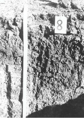 Calcic, Mottled-Mesonatric, Red Sodosol | |
|
Location | Corkers Creek Rd, Longerenong, Western Victoria | |||
|
Landform | Anastomotic plain | |||
|
Geology | Quaternary Coonambidgal Formation: fluvial to lacustrine clays and sands | |||
|
Element | Plain | |||
Horizon | Depth (cm) | Description | ||
A1 | 0–5 | Dark brown (7.5YR3/4); fine sandy clay loam; plastic; hardsetting surface condition; weak coarse angular blocky structure; strong consistence dry, moderately sticky consistence wet; pH 7.8; sharp and wavy change to: | ||
A2 | 5–10 | Brown (7.5YR4/3) sporadically bleached (10YR7/1); fine sandy clay loam; weak coarse blocky structure; pH 8.1; sharp and wavy change to: | ||
B21 | 10–25 | Reddish brown (5YR4/4); light clay; plastic; moderate coarse prismatic structure; strong consistence dry, moderately sticky consistence wet; pH 8.7; sharp and wavy change to: | ||
B22 | 25–45 | Yellowish red (5YR4/6); light clay; plastic; moderate coarse prismatic structure; strong consistence dry, moderately sticky consistence wet; pH 9.3; clear and wavy change to: | ||
B231k | 45–90 | Strong brown (7.5YR5/6) with faint yellowish red (5YR4/6) fine mottles; medium clay; plastic; weak blocky structure; strong consistence dry, moderately sticky consistence wet; contains very few (< 2 %) hard carbonates and a few (2-10%) soft carbonates; pH 9.3: | ||
B232k | 90–130+ | Strong brown (7.5YR5/6) with faint yellowish red (5YR4/6) fine mottles; medium clay; plastic; weak blocky structure; strong consistence dry, moderately sticky consistence wet; contains very few (< 2 %) hard carbonates and a few (2-10%) soft carbonates; pH 9.3. | ||
| Management considerations | ||||
| ||||
Site WIA14 | Sample depth cm | pH | EC dS/m | NaCl % | Ex Ca cmol-/kg | Ex Mg cmol-/kg | Ex K cmol-/kg | Ex Na cmol-/kg | Ex Al mg/kg | Ex acidity cmol-/kg | FC -30okPa | PWP -1500okPa | KS % | FS % | Z % | C % | |
Horizon | H2O | CaCl2 | |||||||||||||||
A1 | 0–5 | 7.8 | NA | 0.11 | 0.01 | 7 | 3.8 | 0.7 | 0.6 | NA | 2.7 | 19.6 | 8.4 | 20 | 45 | 8 | 24 |
A2 | 5–10 | 8.1 | NA | 0.07 | 0.01 | 4.7 | 3.4 | 0.4 | 0.9 | NA | 2 | NA | 6.7 | 22 | 48 | 9 | 20 |
B21 | 10–25 | 8.7 | NA | 0.18 | 0.03 | 10 | 12.5 | 1.6 | 3.9 | NA | 1.3 | NA | 23.3 | 12 | 24 | 5 | 56 |
B22 | 25–45 | 9.3 | NA | 0.48 | 0.06 | 9.4 | 17.1 | 1.6 | 6.8 | NA | NA | NA | 26.7 | 6 | 17 | 4 | 69 |
B31k | 45–90 | 9.3 | NA | 1.03 | 0.13 | 6 | 13.3 | 1.5 | 8 | NA | NA | NA | 23.3 | 9 | 20 | 5 | 55 |
B32k | 90–130 | 9.3 | NA | 1.17 | 0.18 | 5.2 | 12.6 | 1.4 | 7.8 | NA | NA | NA | 20.1 | 13 | 22 | 7 | 47 |
B233 | 130–190 | 9.2 | NA | 1.11 | 0.16 | NA | NA | NA | NA | NA | NA | NA | 20.3 | 12 | 22 | 9 | 53 |
B234 | 190–230 | 8.6 | NA | 1.05 | 0.17 | NA | NA | NA | NA | NA | NA | NA | 21.1 | 11 | 26 | 7 | 54 |