Victorian Resources Online (archived)
WLRA142
|
| WLRA142 | 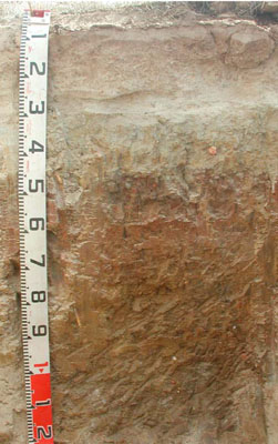 Eutrophic, Mottled-Hypernatric, Brown Sodosol | |
|
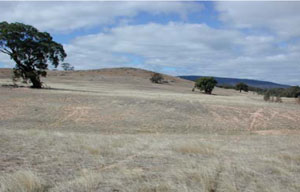
Location | Shays Flat-Malakoff Road, Landsborough, western Victoria | |||
|
Landform | Rolling low hills | |||
|
Geology | Palaeozoic (Cambrian) Warrak Formation: marine sandstone, siltstone, schist | |||
|
Element | Footslope | |||
|
Slope | 6.5% | |||
|
Aspect | South | |||
Horizon | Depth (cm) | Description | ||
A1 | 0–10 | Brown (7.5YR4/3); sandy loam, silty; massive (structureless); weak dry consistence; very few small subrounded gravels; pH 6.0; clear and smooth boundary to: | ||
A2 | 10–30 | Strong brown (7.5YR4/6); conspicuously bleached very pale brown (10YR8/3 dry); silty loam, fine sandy; massive (structureless); weak dry consistence; pH 6.0; clear and smooth boundary to: | ||
A3 | 30–45 | Pale yellow (2.5Y7/3); conspicuously bleached white (10YR8/1 dry) with common fine distinct orange and yellow mottles; silty loam, fine sandy; massive (structureless); strong dry consistence; very few fine earthy root linings; uncemented continuous massive densipan; pH 7.0; abrupt and smooth boundary to: | ||
B21 | 45–80 | Strong brown (7.5YR5/6) with common fine to medium faint orange and yellow mottles; light clay; weak medium prismatic, parting to weak medium angular blocky structure; rough to smooth ped-fabric; strong dry consistence; very few small angular quartz gravels; pH 8.5; gradual and smooth boundary to: | ||
B22 | 80–135+ | Dark yellowish brown (10YR4/4) with many fine (10YR7/6) mottles; light medium clay; massive (structureless); strong dry consistence; very few small angular quartz gravels; very few fine to medium manganiferous nodules; pH 8.0. | ||
| Management considerations | ||||
| ||||
Site WLRA142 | Sample depth cm | pH | EC dS/m | NaCl % | Ex Ca cmol-/kg | Ex Mg cmol-/kg | Ex K cmol-/kg | Ex Na cmol-/kg | Ex Al mg/kg | Ex acidity cmol-/kg | FC -30okPa | PWP -1500okPa | KS % | FS % | Z % | C % | |
Horizon | H2O | CaCl2 | |||||||||||||||
A1 | 0–10 | 5.1 | 4.5 | 0.05 | NA | 1.3 | 0.33 | 0.25 | 0.08 | 24 | NA | 32.4 | 5.4 | 4.7 | 67.7 | 18 | 6.5 |
A2 | 10–30 | 5.2 | 4.7 | <0.05 | NA | NA | NA | NA | NA | NA | NA | NA | NA | NA | NA | NA | NA |
A3 | 30–45 | 7 | 5.9 | 0.08 | NA | 1.3 | 2.1 | 0.09 | 1 | NA | NA | 19.9 | 7.6 | 5.4 | 61.3 | 11.5 | 19.5 |
B21 | 45–80 | 7.5 | 6.4 | 0.2 | NA | 2.7 | 6.7 | 0.31 | 3.7 | NA | NA | 31.9 | 18.7 | 4.1 | 35.5 | 11 | 47 |
B22 | 80–135+ | 8.4 | 7.4 | 0.29 | 0.05 | 1.9 | 7.7 | 0.4 | 5.4 | NA | NA | 31.7 | 18.6 | 2.7 | 43.4 | 10.5 | 38.5 |