Victorian Resources Online (archived)
ALRA064
|
|
| ||
|
Location |
Jallukar Forest, Jallukar | |||
|
Landform |
Gentle plain | |||
|
Geology |
White Hills Gravel: sediments | |||
|
Element |
Footslope | |||
|
Slope |
3% | |||
|
Aspect |
South-west | |||
Description | ||||
Horizon | Depth (cm) | |||
A1 | 0–10 | Greyish brown (10YR5/2); sandy loam; massive (structureless); very weak consistence when moderately moist; few medium sized quartz coarse fragments; pH 6.0; clear boundary to: | 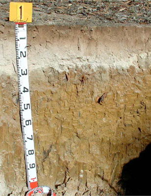 Vertilc, Mottled-Subnatric, Brown SODOSOL | |
A2 | 10–25 | Light yellowish brown (2.5Y6/3); conspicuously bleached (10YR8/1 dry); sand; massive (structureless); very weak consistence when dry; pH 6.5; abrupt boundary to: | ||
B21 | 25–55 | Brown (10YR5/3) with many medium distinct dark yellowish brown (10YR4/6) mottles; medium heavy clay; moderate coarse columnar, parting to moderate medium prismatic structure; smooth ped-fabric; strong consistence when moderately moist; pH 7.0; gradual boundary to: | ||
B22 | 55–85 | Brownish yellow (10YR6/6) with few fine faint orange mottles; medium heavy clay; moderate coarse prismatic structure; smooth fabric; very firm consistence when moderately moist; very few subangular quartz coarse fragments; very few fine manganiferous nodules; few distinct mangans and slickensides; pH 7.0; distinct boundary to: | ||
B23 | 85–100+ | Olive yellow (2.5Y6/6) with few fine faint orange mottles; medium heavy clay; weak coarse polyhedral structure; smooth ped-fabric; very firm consistence when moderately moist; very few subangular quartz coarse fragments; common distinct slickensides; pH 7.0. | ||
Management Considerations: | ||||
| ||||
Chemical Analysis:
Horizon | Depth (cm) | pH (water) | pH (CaCl2) | EC dS/m | NaCl % | Exchangeable Cations cmol-/kg | Field Capacity (pF2.5) | Wilting Point (pF4.2) | Coarse Sand % | Fine Sand % | Silt % | Clay % | |||
Ca | Mg | K | Na | ||||||||||||
A1 | 0–10 | 5.4 | 4.9 | <0.05 | 1.4 | 0.41 | 0.28 | 0.11 | 9.5 | 2.7 | 29.8 | 53.0 | 9.0 | 3.0 | |
A2 | 10–25 | 6.3 | 6.0 | 0.05 | 0.44 | 0.36 | 0.1 | 0.18 | 7.3 | 1.3 | 29.8 | 54.2 | 12.0 | 2.0 | |
B21 | 25-55 | 6.9 | 6.4 | 0.56 | 1.5 | 7.4 | 0.4 | 1.9 | 28.7 | 22.6 | 6.2 | 13.7 | 6.0 | 71.5 | |
B22 | 55-85 | 7.4 | 6.8 | 0.58 | 0.7 | 8.9 | 0.4 | 3.9 | 27.1 | 16.4 | 11.8 | 23.9 | 7.5 | 53.5 | |
B23 | 85--100+ | 7.5 | 6.9 | 0.62 | 0.14 | 0.7 | 8.9 | 0.3 | 4.3 | 10.5 | 15.2 | 13.2 | 23.0 | 13.5 | 49.0 |