Victorian Resources Online (archived)
ESAS14
Location: Minimay
Australian Soil Classification: Vertic, Mesonatric, SODOSOL
General Landscape Description: Level plan.
Site Description: Continuous cropping paddock under a centre pivot. Lower yielding area when compared to ESAS13.
Soil Profile Morphology:
| Surface Soil | |||
| Ap | 0-15 cm | Sandy clay loam; firm surface condition; pH 7.9: | |
| Subsoil | |||
| B21 | 15-35 cm | Light clay; strong medium prismatic, parting to strong medium angular blocky structure; a few distinct slickensides evident; pH 8.9: | |
| B22 | 35-50 cm | Light medium clay; strong medium prismatic, parting to strong medium angular blocky structure; pH 9.1: | |
| B23 | 50-80 cm | Medium clay; strong medium prismatic, parting to strong fine prismatic structure; strong consistence, moist; few distinct slickensides evident; pH 9.6: | |
| B24 | 80-100 cm | Medium clay; pH 9.6: | |
| B25 | 100+ cm | Medium clay; pH 9.4. | |
Soil Profile Characteristics:
pH | Salinity Rating | |||
Surface (A1 horizon) | Slightly Alkaline | Medium | Sodic | Moderate |
Subsoil (B21 horizon) | Strongly Alkaline | Medium to High | Strongly Sodic | Strong 1 |
Deeper Subsoil (at 80-100 cm) | Extremely Alkaline | High | Extremely Sodic | Nil 2 |
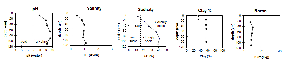
| The surface is slightly alkaline. The upper subsoil is strongly alkaline becoming extremely alkaline with depth. | The salinity rating for the surface is medium. The subsoil has a medium to high salinity rating.
| The surface is sodic. The upper subsoil is strongly sodic becoming extremely sodic with depth. | The clay content increases significantly at the A/B boundary. | Boron levels are fairly consistent throughout the profile. |
Chemical and Physical Analysis:
Horizon | Horizon Depth (cm) | pH (water) | pH (CaCl2) | EC dS/m | Chloride mg/kg | Exchangeable Cations | |||
Ca | Mg | K | Na | ||||||
meq/100g | |||||||||
Ap | 0-15 | 7.9 | 7.4 | 0.44 | 0.032 | 11 | 7.3 | 1 | 2.6 |
B21 | 15-35 | 8.9 | 8.3 | 0.79 | 0.109 | 11 | 16 | 0.97 | 7.6 |
B22 | 35-50 | 9.1 | 8.6 | 0.96 | 0.126 | 8.6 | 18 | 1.1 | 10 |
B23 | 50-80 | 9.6 | 8.9 | 0.94 | 0.12 | 4 | 12 | 0.81 | 9.7 |
B24 | 80-100 | 9.6 | 8.9 | 0.91 | 0.118 | 4.2 | 11 | 0.85 | 11 |
B25 | 100+ | 9.4 | 8.7 | 1.1 | 0.159 | 6.5 | 13 | 0.92 | 13 |
Horizon | Horizon Depth (cm) | Oxidisable Organic Carbon % | Total Nitrogen % | Boron % | Field Capacity pF2.5 | Wilting Point pF4.2 | Coarse Sand (0.2-2.0 mm) | Fine Sand (0.02-0.2 mm) | Silt (0.002-0.02 mm) | Clay (<0.002 mm) |
Ap | 0-15 | 1.7 | 0.15 | 27.8 | 15.1 | 18 | 32 | 10 | 33 | |
B21 | 15-35 | 7.5 | 45.0 | 21.6 | 12 | 21 | 8 | 53 | ||
B22 | 35-50 | 10 | 51.8 | 24.0 | 11 | 19 | 9 | 54 | ||
B23 | 50-80 | 9.3 | 38.4 | 18.7 | ||||||
B24 | 80-100 | 8.3 | 40.6 | 18.3 | ||||||
B25 | 100+ | 8.2 | 44.0 | 20.0 |
Profile Described By: Bernard Noonan and Melissa Cann (March 2009).