Victorian Resources Online (archived)
IS20
Location: Drung Drung
Soil Type: Haven Sandy Clay Loam
Australian Soil Classification: Hypocalcic, Subnatric, Grey SODOSOL
Northcote Factual Key: Dy 2.33
Great Soil Group: solodic soil
General Description: Terrace flat.
Geology: Quaternary Coonambidgal Formation: fluvial to lacustrine clays and sands
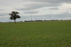
IS20 Landscape
Soil Profile Morphology:
Surface Soil
| A1 | 0-5 cm | Greyish brown (10YR5/2) sandy clay loam; plastic; hardsetting surface condition; weak coarse blocky structure; strong consistence dry, slightly sticky consistence wet; pH 6.6; sharp and smooth change to: | 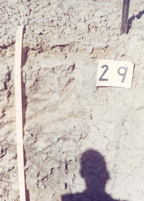 IS20 Profile |
| Subsoil | |||
| B21 | 5-30 cm | Grey (10YR5/1) light clay; subplastic; weak coarse subangular blocky structure; strong consistence dry, moderately sticky consistence wet; pH 7.5; gradual change to: | |
| B22 | 30-60 cm | Grey (5Y5/1) light clay; subplastic; weak coarse blocky structure; strong consistence dry, moderately sticky consistence wet; contains a trace (<2%) amount of hard carbonate; pH 8.9; gradual and smooth change to: | |
| B23 | 60-85 cm | Grey (5Y5/1) light clay; subplastic; weak coarse blocky structure; strong consistence dry, moderately sticky consistence wet; contains a trace (<2%) amount of hard carbonate; pH 8.0: | |
| B24 | 85-100 cm | Grey (5Y5/1) medium clay; subplastic; weak coarse blocky structure; strong consistence dry, moderately sticky consistence wet; contains a trace (<2%) amount of hard carbonate; pH 7.7. | |
Horizon | Sample Depth cm | pH H2O | EC dS/m | Sodium Chloride % | Exchangeable Calcium cmol-/kg | Exchangeable Magnesium cmol-/kg | Exchangeable Potassium cmol-/kg | Exchangeable Sodium cmol-/kg | Total Nitrogen % | Organic Carbon % | Bulk Density | Exchangeable Acidity cmol-/kg | Field Capacity -30okPa | Permanent Wilting Point -1500okPa | Coarse Sand % | Fine Sand % | Silt % | Clay % |
A1 | 0–5 | 6.6 | 0.15 | 0.03 | 5 | 7.3 | 0.8 | 1 | 0.1 | 5.0 | 1.22 | 6 | 23.5 | 12.6 | 6 | 46 | 15 | 33 |
B21 | 5–30 | 7.5 | 0.19 | 0.03 | 9.1 | 13.8 | 0.9 | 2.9 | 0.06 | 0.49 | 1.51 | 2.9 | 19.1 | 4 | 27 | 13 | 54 | |
B22 | 30–60 | 8.9 | 0.46 | 0.06 | 9.8 | 15.1 | 1 | 4.1 | 0.05 | 0.48 | 1.45 | 4.2 | 19.8 | 3 | 24 | 16 | 55 | |
B23 | 60–85 | 8.0 | 0.9 | 0.1 | 9.8 | 15.1 | 1.1 | 4.6 | 0.04 | 0.38 | 1.49 | 3 | 19.8 | 4 | 24 | 17 | 55 | |
B24 | 85–100 | 7.7 | 2.16 | 0.12 | 11.6 | 16.2 | 1.1 | 5.4 | 0.02 | 0.22 | 1.51 | 2.4 | 21.7 | 2 | 20 | 17 | 58 | |
B25 | 100-150 | 8.5 | 0.81 | 0.12 | 9.2 | 15.5 | 1.2 | 5.3 | 0.02 | 0.11 | 2.2 | 21.6 | 4 | 22 | 16 | 56 | ||
B26 | 150-215 | 9.0 | 0.77 | 0.12 | 6 | 18 | 12 | 58 |
Management Considerations:
- Texture contrast soil, possible cracking clay (vertosol)
- Slightly acid to neutral thin surface soil over neutral to alkaline subsoil
- Hard setting, coarsely structured surface soil, not ideal for plant establishment
- Subsoil has vertic properties, including subplasticity (feels lighter than lab data suggests), limited obvious structure
- Subsoil is slightly sodic (subnatric), more sodic at depth and high magnesium
- Yellow hue (5Y) would suggest reducing conditions , poor internal drainage as clay in subsoil expands
- Landscape element, terrace flat; slow site drainage unless near drainage line
Profile Described By: John Martin, Nabil Badawy, Ron Cawood, Geoff Pope, John Galea, John Turner (1970).
Reference: "Major Agricultural Soils of the Wimmera Irrigation Area". John Martin, Mark Imhof, Lourey Ruth, Rob Nink, Karen DePlater, Paul Rampant, Sonia Thompson, S. Alexander. Department of Natural Resources and Environment, Victoria. 1996.