Victorian Resources Online (archived)
LS13b
Location: Netherby
Australian Soil Classification: Vertic, Pedal, Calcic, CALCAROSOL
Northcote Factual Key: Gc2.2
General Landscape Description: Gently Undulating Plain near footslopes of Gently Undulating Rises unit. In a relatively low lying area in association with Grey Vertosols.
Site Description: Cropping. Gilgai micro-relief occurs.
Native Vegetation: Black Box (Eucalyptus largiflorens) is the natural vegetation.
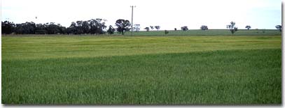
LS13b Landscape
Soil Profile Morphology:
Surface Soil .
| A1 | 0-10 cm | Very dark greyish brown (10YR3/2); fine sandy clay loam; weakly structured; firm consistence dry; pH 8.5: | 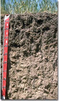 LS13b Profile |
| Subsoil | |||
| B1 | 10-15 cm | Dark grey (10YR4/1); fine sandy light clay; weak coarse subangular blocky blocky structure; firm consistence dry; pH 8.6: | |
| B21 | 15-35 cm | Dark grey (10YR4/1); heavy clay; moderate coarse prismatic, breaking to strong coarse blocky structure; very firm consistence dry; pH 9.2; clear boundary change to: | |
| B22 | 35-70 cm | Greyish brown (10YR5/2); heavy clay; moderate coarse prismatic, breaking to moderate coarse blocky structure; weak consistence moist; contains few (2 - 10%) soft carbonate segregations; pH 9.7; gradual change to: | |
| B23 | 70+ cm | Light grey (10YR7/2); heavy clay; pH 9.8 | |
Key Profile Features:
- Gradual increase in soil texture to heavy clay subsoil.
- Vertic properties in deeper subsoil.
Soil Profile Characteristics:
| - | pH | Salinity | ||
Surface (A1 horizon) | Moderately Alkaline | Low | Non-Sodic | Slaking, No dispersion1 |
Subsoil (B21 horizon) | Very Strongly Alkaline | Low | Sodic | Slight 2 |
Deeper Subsoil (at 70 cm) | Extremely Alkaline | Medium | Strongly Sodic | _ |
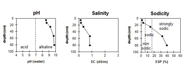
| The surface soil is moderately alkaline. The subsoil is very strongly alkaline becoming extremely alkaline with depth. | The salinity rating is low in the surface and upper subsoil becoming medium with depth. | The surface is non-sodic. The subsoil is sodic becoming strongly sodic with depth. |
Chemical and Physical Analysis:
Horizon | Horizon Depth (cm) | pH (water) | pH (CaCl2) | EC dS/m | Sodium Chloride % | Exchangeable Cations | |||
Ca | Mg | K | Na | ||||||
meq/100g | |||||||||
A1 | 0-10 | 8.5 | 7.8 | 0.12 | 18.9 | 4 | 2 | 0.2 | |
B1 | 10-15 | 8.6 | 7.9 | 0.14 | 19.9 | 5.8 | 1.9 | 0.7 | |
B21 | 15-35 | 9.2 | 8.3 | 0.34 | <0.05 | 15.7 | 12 | 1.7 | 4.5 |
B22 | 35-70 | 9.7 | 9 | 0.82 | 0.08 | 4.5 | 13 | 1.5 | 8.6 |
B23 | 70+ | 9.8 | 9.1 | 0.82 | 0.11 | 3.1 | 12 | 1.5 | 10.6 |
Horizon | Horizon Depth (cm) | Total Nitrogen % | Oxidisable Organic Carbon % | Field Capacity pF2.5 | Wilting Point pF4.2 | Coarse Sand (0.2-2.0 mm) % | Fine Sand (0.02-0.2 mm) % | Silt (0.002-0.02 mm) % | Clay (<0.002 mm) % |
A1 | 0-10 | 0.12 | 1.2 | 21 | 15.1 | 20 | 27 | 8 | 36 |
B1 | 10-15 | 31.7 | 19.8 | ||||||
B21 | 15-35 | 22 | 23 | 7 | 34 | ||||
B22 | 35-70 | ||||||||
B23 | 70+ |
Management Considerations:
Surface (A) Horizon
- Surface and subsurface horizons (ie. to a depth of 15 cm) are non-sodic but will slake when rapidly wet. Improving organic matter levels will help reduce slaking. Practices which result in increased soil organic matter levels (eg. direct drilling, stubble retention, including pasture rotations) should be utilised.
- The surface soil disperses after remoulding which indicates that disturbance to this horizon (eg. cultivation) whilst in a moist to wet condition can result in structural degradation.
Subsoil (B) Horizons
- The coarsely structured upper subsoil is sodic and disperses slightly. This may result in conditions which restrict root and water movement into the subsoil.
- The very strongly alkaline subsoil (below 30 cm depth) indicates that nutrients such as iron, manganese, copper and zinc may be poorly available to plants at depth.
- Soluble salts may cause problems to sensitive crops (e.g. chickpeas and other legumes) from 35 cm and below. On the pit face many roots were present (mainly along ped faces) down to 35 cm.
Comments from Landholder:
- Land cleared in 1880.
- Direct drilling used as cultivation method.
- Superphosphate and nitrogen applied.
- Continuously cropped since 1989 with grains (wheat, barley) and legumes (chickpeas, faba beans).
Profile Described By: Mark Imhof, John Martin, David Rees, Sonia Thompson (May 1994).