Victorian Resources Online (archived)
LS14
Location: Propodollah
Australian Soil Classification: Eutrophic, Subnatric, Brown SODOSOL (deep sandy)
Northcote Factual Key: Dy 4.41
Great Soil Group: soloth
General Landscape Description: Crest of a dune on a gently undulating sand plain.
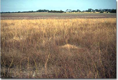 LS14 Landscape |
Soil Profile Morphology:
Surface Soil
| A11 | 0-15cm | Dark brown (10YR4/3); loamy sand; weakly structured; loose consistence dry; pH 6.7: | 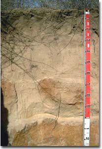 LS14 Profile |
| A12 | 15-35 cm | Brown (7.5YR4/4); loamy sand; structureless; loose consistence dry: | |
| A2 | 35-100 cm | Brown (7.5YR5/4); sand; (drying out to a bleached colour); structureless; loose consistence dry; pH 6.8: Note: Within this horizon massive yellowish red (5YR5/8); clayey sand (6% clay) areas occur which are of firm consistence dry; pH 6.1 (referred to as a B1 horizon). | |
| Subsoil | |||
| B21 | 100-160 cm | Strong brown (7.5YR5/6) with yellowish brown (10YR5/8) mottles; coarse sandy loam (16% clay); weak coarse columnar structure and very strong consistence dry. The top of the columnar structure has a hard bleached capping; pH 6.3: | |
| B22 | 160+ | Yellowish brown (10YR5/8); coarse sandy loam; massively structured; very strong consistence dry. | |
Key Profile Features:
- Deep sandy A horizons to 1m depth.
Soil Profile Characteristics:
pH | Salinity | |||
Surface (A1 horizon) | Slightly Acid | Very Low | Non-Sodic | _ |
Subsoil (B21 horizon) | Slightly Acid | Very Low | Sodic | _ |
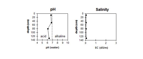
| The soil is slightly acid throughout. |
|
Chemical and Physical Analysis:
Horizon | Horizon Depth (cm) | pH (water) | pH (CaCl2) | EC dS/m | Exchangeable Cations | |||
Ca | Mg | K | Na | |||||
meq/100g | ||||||||
A11 | 0-15 | 6.7 | 6 | <0.05 | 1.8 | 0.5 | 0.1 | <0.1 |
A12 | 15-35 | - | - | - | - | - | - | - |
A2 | 35-60 | 6.8 | 5.9 | <0.05 | 0.5 | 0.1 | <0.1 | <0.1 |
B1 | 60-100 | 6.1 | 4.9 | <0.05 | 1.8 | 0.9 | 0.1 | <0.1 |
B21 | 100-160 | 6.3 | 4.9 | 0.06 | 2 | 2.9 | 0.1 | 0.5 |
B22 | 160+ | |||||||
Horizon | Horizon Depth (cm) | Total Nitrogen % | Oxidisable Organic Carbon % | Field Capacity pF2.5 | Wilting Point pF4.2 | Coarse Sand (0.2-2.0 mm) % | Fine Sand (0.02-0.2 mm) % | Silt (0.002-0.02 mm) % | Clay (<0.002 mm) % |
A11 | 0-15 | 0.06 | 1.1 | 3.7 | 2.1 | ||||
A12 | 15-35 | - | - | - | - | - | - | - | - |
A2 | 35-60 | 3 | 0.9 | ||||||
B1 | 60-100 | 5.2 | 2.8 | 64 | 28 | 2 | 6 | ||
B21 | 100-160 | 60 | 22 | 1 | 16 | ||||
B22 | 160+ |
Management Considerations:
Surface (A) Horizons
- The surface soil is prone to wind erosion, but this is limited to some extent by vegetation cover and reasonable levels of organic matter which promote surface aggregation.
- The low water holding capacity of the surface soil horizon will also be improved by increasing surface organic matter levels.
- Sandy surface horizons have a very low inherent fertility as well as low levels of total nitrogen. High leaching rates are likely to result in nutrients being removed more readily. Increasing organic matter levels in light textured surface soils will improve nutrient holding capacity.
- The sodic subsoil horizon (with hard surface capping) is likely to restrict water movement and may affect root penetration of deeper rooted plants. Lateral movement of water will occur above the relatively impermeable subsoil after heavy rain.
- Mallee cleared around 1900.
- Skeleton weed is a problem.
- Chisel plough used for cultivation.