Victorian Resources Online (archived)
LS17
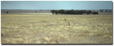
Location: Big Desert.
Australian Soil Classification: Calcic, Mottled-Subnatric, Yellow SODOSOL (sandy surface horizon)
Northcote Factual Key: Dy 5.43
Great Soil Group: solodized solonetz
General Landscape Description: Crest of a dune on a gently undulating sand rise (dunefield) south of the Big Desert.
Native Vegetation: Mallee.
 LS17 Landscape |
Soil Profile Morphology:
Surface Soil
| A1 | 0-10 cm | Light yellowish brown (10YR6/4); loamy sand; weakly structured; pH 7.7: | 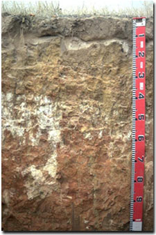 LS17 Profile |
| A2 | 10-15 cm | Light yellowish brown (10YR6/4) conspicuously bleached; fine sand; pH 8.6; sharp and wavy change to: | |
| Subsoil | |||
| B21 | 15-30 cm | Light yellowish brown (10YR6/4) with brownish yellow (10YR6/6) mottles; coarse sandy clay loam; weak to moderate coarse columnar structure with hard bleached capping; strong consistence dry; pH 8.9; clear and wavy change to: | |
| B22k | 30-60 cm | Light yellowish brown (10YR6/4) with yellowish red (5YR5/6) mottles; light medium clay (sandy); moderate coarse prismatic, parting to strong coarse blocky structure; ped faces may have a discontinuous carbonate coating; pH 9.4: | |
| B31k | 60-100 cm | Red (2.5YR4/8) with strong brown (7.5YR5/6) mottles; coarse sandy clay loam; massively structured; strong consistence dry; contains few (5 %) calcareous nodules; pH 9.6: | |
| B32 | 100-150 cm | Light yellowish brown (10YR6/4) with yellowish red (5YR5/6) mottles; medium clay (sandy); moderate medium blocky structure; contains very few (< 2%) hard carbonate nodules; pH 9.8: | |
| B33 | 150+ cm | Yellowish red (5YR5/6) with light yellowish brown (10YR6/4) mottles; medium clay (sandy); pH 9.8. |
Key Profile Features:
- Distinct texture contrast between sandy surface (A) horizons and clay subsoil (B21) horizon.
- Soft surface soil condition (ie. not hard-setting).
- Thin, conspicuously bleached subsurface (A2) horizon.
- Coarse columnar structure with hard bleaching capping at top of B horizon.
Soil Profile Characteristics:
pH | Salinity | |||
Surface (A1 horizon) | Slightly Alkaline | Very Low | Non-Sodic | None |
Subsoil (B21 horizon) | Strongly Alkaline | Very Low | Strongly Sodic | Strong |
Deeper Subsoil (at 1 metre) | Extremely Alkaline | Low-Medium | Strongly Sodic | Strong |
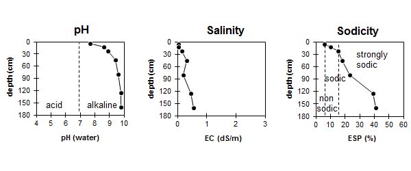
| The surface soil is slightly alkaline. The subsoil is strongly alkaline becoming extremely alkaline at depth. | The salinity rating is very low in the surface and upper subsoil becoming moderate with depth. | The surface is non-sodic. The subsoil is strongly sodic. |
Chemical and Physical Analysis:
Horizon | Horizon Depth (cm) | pH (water) | pH (CaCl2) | EC dS/m | Sodium Chloride % | Exchangeable Cations | |||
Ca | Mg | K | Na | ||||||
meq/100g | |||||||||
A1 | 0-10 | 7.7 | 7.1 | <0.05 | 0.9 | 0.4 | 0.2 | 0.1 | |
A2 | 10-15 | 8.6 | 7.9 | <0.05 | 0.6 | 02 | 0.1 | 0.1 | |
B21 | 15-30 | 8.9 | 7.8 | 0.15 | 4.8 | 4.6 | 0.7 | 1.7 | |
B22 | 30-60 | 9.4 | 8.5 | 0.32 | <0.05 | 6.7 | 8 | 1.2 | 3.4 |
B31 | 60-100 | 9.6 | 8.4 | 0.2 | 3.4 | 5.7 | 0.7 | 2.9 | |
B32 | 100-150 | 9.8 | 8.8 | 0.46 | <0.05 | 3 | 8 | 1 | 7.5 |
B33 | 150+ | 9.8 | 8.8 | 0.55 | <0.05 | 2.9 | 7.8 | 1 | 7.9 |
Horizon | Horizon Depth (cm) | Total Nitrogen % | Oxidisable Organic Carbon % | Field Capacity pF2.5 | Wilting Point pF4.2 |
A1 | 0-10 | <0.05 | 0.3 | 2.9 | 1.4 |
A2 | 10-15 | <0.05 | 0.1 | 1.9 | 1.1 |
B21 | 15-30 | 19.1 | 11.3 | ||
B22 | 30-60 | ||||
B31 | 60-100 | ||||
B32 | 100-150 | ||||
B33 | 150+ |
Management Considerations:
Surface (A) Horizons
- The shallow sandy surface horizons are prone to wind erosion which would expose the strongly sodic and dispersive subsoil to water erosion. Organic matter levels and surface cover need to be maintained to restrict wind erodibility.
- The surface soil has a very low inherent fertility (based on the sum of the exchangeable basic cations) and low organic matter and total nitrogen levels. Increasing organic matter levels will improve soil nutrient holding capacity.
- The available water capacity is very low for the surface horizons due to their sandy texture. However, the low wilting point value (ie.1.5%) suggests that plants would be able to utilise light rains falling on dry soil. However, overall plant available water capacity will be very low.
Subsoil (B) Horizons
- The dense and coarsely structured subsoil is strongly sodic and dispersive. Root and water movement into the subsoil will be significantly restricted as a result. The hard bleached capping will present a major barrier to root movement. The conspicuously bleached subsurface (A2) horizon indicates that periodic waterlogging may occur above the subsoil following heavy rains. Lateral movement of water (downslope) above this horizon is likely to occur.
- The strongly alkaline subsoil indicates that some nutrients (eg. iron, manganese, copper and zinc) may be poorly available to plants. Plant tissue analysis can be performed to assess deficiencies.
Profile Described By: Mark Imhof, John Martin, David Rees, Austin Brown, Geof Morrow, Sonia Thompson (May 1994).