Victorian Resources Online (archived)
LS4
Location: Diapur Ridge
Australian Soil Classification: Eutrophic, Mottled-Subnatric, Grey SODOSOL (deep sandy)
Northcote Factual Key: Dy 4.12
Great Soil Group: soloth
General Landscape Description: Crest on the spur of a north-south trending ridge. Average slope ranges from 3 - 5%.
Natural Vegetation: dominated by Mallee and Yellow Gum (Eucalyptus leucoxylon).
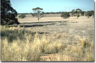 LS4 Landscape (soil profile occurs near foreground of photo). |
Soil Profile Morphology:
Surface Soil
| A10 | 0-5 cm | Very dark greyish brown (10YR3/2); loamy sand; weak granular structure; weak consistence dry; pH 6.5: | 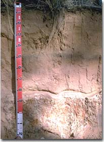 LS4 Profile |
| A11 | 5-45 cm | Dark yellowish brown (10YR4/6); sand; structureless; pH 6.7: | |
| A12 | 45-50 cm | Dark reddish brown (5YR3/3); loamy sand; pH 6.2: | |
| A13 | 50-80 cm | Yellowish red (5YR4/8); sand; with a common (10 -20%) amount of ironstone nodules; pH 6.7: | |
Subsoil | |||
| B21 | 80-110 cm | Very pale brown (10YR7/3) and red (2.5YR3/8) mottles; heavy clay; coarse columnar, parting to strong coarse prismatic structure; hard bleached capping at top of columnar structure; very strong consistence dry; pH 6.5: | |
| C | 110 cm+ | Weathered sandstone. | |
Key Profile Features:
- Deep sandy surface soil (ie. 80 cm).
- Strong texture contrast between sandy surface horizons and clay subsoil.
Soil Profile Characteristics:
| - | pH | Salinity | ||
Surface (A1 horizon) | Slightly Acid | Very Low | Non-Sodic | None |
Subsoil (B21 horizon) | Slightly Acid | Very Low | Sodic | None |
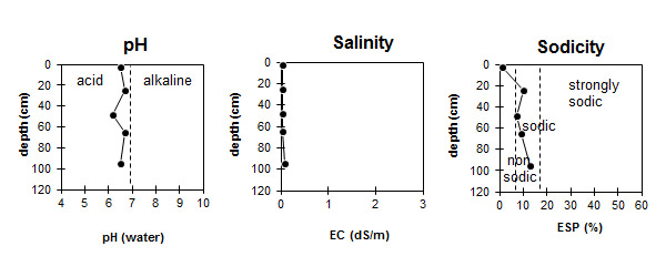
| The profile is slightly acid throughout the profile. | The salinity rating is very low throughout the profile. | The surface is non-sodic in the surface. The subsoil is sodic throughout. |
Horizon | Horizon Depth (cm) | pH (water) | pH (CaCl2) | EC dS/m | Oxidisable Organic Carbon % | Total Nitrogen % | Exchangeable Cations | |||
Ca | Mg | K | Na | |||||||
meq/100g | ||||||||||
A10 | 0-5 | 6.5 | 5.8 | <0.05 | 1.3 | 0.08 | 2.7 | 0.5 | 0.1 | <0.1 |
A11 | 5-45 | 6.7 | 5.8 | <0.05 | 0.6 | 0.2 | <0.1 | <0.1 | ||
A12 | 45-50 | 6.2 | 5.0 | <0.05 | 0.3 | <0.05 | 1.1 | 0.3 | 0.1 | <0.1 |
A13 | 50-80 | 6.7 | 5.7 | <0.05 | 0.7 | 0.3 | <0.1 | <0.1 | ||
B21 | 80-110 | 6.5 | 5.2 | 0.09 | 3.4 | 6.5 | 0.1 | 1.4 | ||
Horizon | Horizon Depth (cm) | Field Capacity pF2.5 | Wilting Point pF4.2 |
A10 | 0-5 | 4.4 | 4.3 |
A11 | 5-45 | 3.5 | 0.9 |
A12 | 45-50 | ||
A13 | 50-80 | ||
B21 | 80-110 | 20.6 | 14.2 |
Management Considerations:
Surface (A) Horizons
- The sandy surface horizons are susceptible to wind erosion. Wind erodibility can be reduced by maintaining surface cover and organic matter levels.
- The sandy surface horizons have a very low inherent fertility. Most of the nutrients are likely to occur in the top 5 cm layer. Organic matter is important in these light textured surface soil for holding nutrients. Leaching of applied nutrients beyond the root zone of shallow rooted plants is likely.
- The deep sandy horizons have a low plant available water capacity and high water infiltration rates. Due to the low wilting point, however, plants will be able to utilise light rains falling on relatively dry soil.
- The sodic and strongly dispersive subsoil occurs at 80 cm+ and is only likely to restrict deep rooted species. Water movement will be restricted by the subsoil and may result in the sand above it becoming saturated after heavy rainfall. Lateral movement of water above the subsoil may also occur on sloping land.