Victorian Resources Online (archived)
LS8
Location: Broughton
Australian Soil Classification: Vertic (and Calcic), Mesonatric, Red SODOSOL
Northcote Factual Key: Dr 2.13
Great Soil Group: red-brown earth (sodic)
General Landscape Description: Gently undulating plain. This site occurs near the base of a Gently Undulating Rises unit.
Geology: Quaternary Woorinen Formation: aeolian dune sand, calcareous clay
Native Vegetation: Buloke (C. leuhmanni).
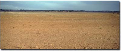 LS8 Landscape |
Soil Profile Morphology:
Surface Soil
| A1 | 0-8 cm | Dark brown (7.5YR3/3); fine sandy clay loam; weakly structured; firm consistence dry; pH 6.8: | 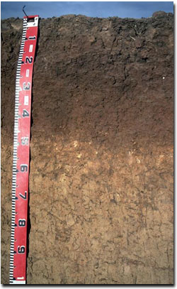 LS8 Profile |
Subsoil | |||
| B21 | 8-14 cm | Reddish brown (5YR4/4); light medium clay; strong coarse blocky structure; very strong consistence dry; pH 8.0: | |
| B22 | 14-30 cm | Yellowish red (5YR4/6); medium clay; strong medium prismatic, parting to strong fine blocky structure; strong consistence dry; pH 8.6: | |
| B23 | 30-45 cm | Yellowish red (5YR3/6); heavy clay; strong medium prismatic, parting to strong fine blocky structure; strong consistence dry; pH 8.9: | |
| B24k | 45-70 cm | Light brown (7.5YR6/4) and dark brown (7.5YR3/2); light medium clay; contains a common (10 - 20%) amount of soft and hard carbonate; pH 9.2: | |
| B25 | 70-100 cm | Light yellowish brown (10YR6/4); heavy clay; moderate to strong prismatic structure; pH 9.1: | |
| B26 | 100-140 cm | Light yellowish brown (10YR6/4); heavy clay; moderate to strong lenticular structure; pH 9.0. |
- Texture contrast between surface (A1) and clay subsoil horizons.
- Shallow and hardsetting surface soil.
- Vertic properties (lenticular structure) in deep subsoil.
Soil Profile Characteristics:
| - | pH | Salinity | ||
Surface (A1 horizon) | Slightly Acid | Very Low | Near Sodic | Slaking, No Dispersion 1 |
Subsoil (B21 horizon) | Moderately Alkaline | Very Low | Strongly Sodic | Strong |
Deeper Subsoil (at 1 metre) | Very Strongly Alkaline | Extremely High | Strongly Sodic | Strong |
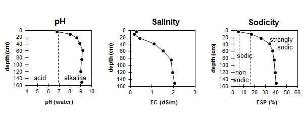
| The surface soil is slightly acid. The subsoil is moderately alkaline becoming very strongly alkaline with depth. | The salinity rating is very low in the surface and in the upper subsoil becoming extremely high with depth. | The surface is near sodic. The subsoil is strongly sodic. |
Chemical and Physical Analysis:
Horizon | Horizon Depth (cm) | pH (water) | pH (CaCl2) | EC dS/m | Sodium Chloride % | Exchangeable Cations | |||
Ca | Mg | K | Na | ||||||
meq/100g | |||||||||
A1 | 0-8 | 6.8 | 6.2 | 0.28 | 6.5 | 3.9 | 1.2 | 0.5 | |
B21 | 8-14 | 8.0 | 6.8 | 0.18 | 7.6 | 5.4 | 0.7 | 2.8 | |
B22 | 14-30 | 8.6 | 7.6 | 0.43 | 9.7 | 8.4 | 0.8 | 6.4 | |
B23 | 30-45 | 8.9 | 8.2 | 1.1 | 0.22 | 9.8 | 11.4 | 1.0 | 11.3 |
B24 | 45-70 | 9.2 | 8.5 | 1.5 | 0.27 | 7.1 | 9.4 | 1.0 | 9.9 |
B25 | 70-100 | 9.1 | 8.5 | 1.88 | 0.35 | 8.4 | 11.7 | 1.2 | 12.6 |
B26 | 100-140 | 9.0 | 8.5 | 1.95 | 0.38 | 8.4 | 11.6 | 1.1 | 13.5 |
B27 | 140+ | 9.1 | 8.6 | 2.05 | 0.36 | 9.0 | 12.1 | 1.4 | 14.6 |
Horizon | Horizon Depth (cm) | Oxidisable Organic Carbon % | Total Nitrogen % | Field Capacity pF2.5 | Wilting Point pF4.2 | Coarse Sand (0.2-2.0 mm) % | Fine Sand (0.02-0.2 mm) % | Silt (0.002-0.02 mm) % | Clay (<0.002 mm) % |
A1 | 0-8 | 1.6 | 0.15 | 16.0 | 10.6 | 23 | 45 | 8 | 19 |
B21 | 8-14 | 0.9 | 0.09 | 24.3 | 16.1 | 21 | 37 | 6 | 30 |
B22 | 14-30 | 36.7 | 19.1 | ||||||
B23 | 30-45 | ||||||||
B24 | 45-70 | ||||||||
B25 | 70-100 | ||||||||
B26 | 100-140 | ||||||||
B27 | 140+ |
Management Considerations:
- Texture contrast between surface (A1) and clay subsoil horizons.
Surface (A) Horizons
- Shallow and hardsetting surface soil. Susceptible to sheet and rill erosion Some physical resistance into subsoil.
- When dry, the surface soil will set hard and become difficult to work. Improving soil organic matter will help ameliorate this condition and assist in reducing slaking. Practices such as stubble retention, minimum tillage and including pasture rotations should be utilised if cropping occurs. Increasing organic matter levels will assist in reducing surface soil slaking as well as increasing surface soil fertility and water holding capacity.
- The surface soil slakes when rapidly wet, which can lead to the development of surface crusting. Dispersion is also likely to occur as a result of mechanical disturbance due to over cultivation or stock trampling when the soil is wet (as indicated by strong dispersion occurring after remoulding). This will result in a reduction of surface soil structural condition and lead to surface sealing - which will restrict seedling emergence and water infiltration and create increased water runoff. Gypsum application may be beneficial on such soils. Benefits of gypsum could be assessed by using a test strip.
- Raindrop impact on bare soil would also have a deleterious effect on soil structure (as indicated by strong dispersion occurring after remoulding), leading to surface sealing. Maintaining a protective cover of vegetation or stubble is important.
Subsoil (B) Horizons
- The strongly sodic subsoil, which also disperses strongly, will restrict water and root movement from about 10 cm in depth. The high levels of exchangeable sodium may also result in nutrient imbalances and may even have a toxic effect on some plants. The addition of gypsum with deep ripping has been advocated by some researchers as an ameliorative technique for sodic subsoils. A test strip could be used to assess likely benefits.
- Strong structure in upper subsoil and brighter (reddish) colours would suggest adequate drainage and gas movement for this part of the profile.
- Soluble chloride salts are likely to cause problems to sensitive crops (eg. lucerne, faba beans and linseed) from 30 cm and deeper.
- Vertic properties (lenticular structure) in deep subsoil.
- Alkaline subsoil with high magnesium and evident calcium carbonate .
- Deeper subsoil likely to be highly dispersive.
Comments from Landholder:
- Gypsum has not been used.
- Rainwater run off is quite high.
- Soil can become "soupy" below the surface.
- This soil is typical of the Broughton area.
Profile Described By: Mark Imhof, David Rees, Sonia Thompson (May 1994).