Victorian Resources Online (archived)
LSWW04b
| 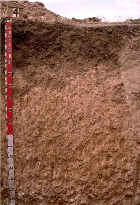 Endocalcareous, Epipedal, Brown VERTOSOL | |||
|
Location | Lillimur, western Victoria | |||
|
Landform | Rise | |||
|
Geology | Quaternary Woorinen Formation: aeolian dune sand, calcareous clay | |||
|
Element | Hillslope | |||
Horizon | Depth (cm) | Description | ||
A1 | 0–10 | Very dark greyish brown (10YR3/2); light clay; moderate coarse blocky, parting to fine polyhedral structure: | ||
B21 | 10–50 | Dark brown (10YR3/3); light clay; moderate coarse blocky, parting to fine polyhedral structure; pH 8.7: | ||
B22k | 50–140 | Reddish yellow (7.5YR7/6); light clay; strong coarse and medium, parting to medium subangular blocky structure; many soft calcareous segregations; pH 9.1: | ||
B23k | 140–170 | Reddish yellow (7.5YR6/6); medium clay; moderate coarse prismatic, parting to strong coarse subangular blocky and moderate medium blocky structure; smooth ped-fabric; many soft calcareous segregations. | ||
| Management Considerations | ||||
| ||||
Horizon | Depth (cm) | pH (water) | pH (CaCl2) | EC dS/m | Exchangeable Cations cmol-/kg | Wilting Point (pF4.2) | Coarse Sand % | Fine Sand % | Silt % | Clay % | |||
Ca | Mg | K | Na | ||||||||||
A1 | 0–10 | ||||||||||||
B21 | 10–50 | 8.7 | 8 | 0.12 | 21 | 4 | 1.2 | 0.5 | 19.0 | 12.7 | 26 | 5.5 | 38 |
B22k | 50–140 | 9.1 | 8.1 | 0.14 | 12 | 6.3 | 0.8 | 0.7 | 17.7 | 5.6 | 13.4 | 3.5 | 29.5 |
B23k | 140–170 | ||||||||||||