Victorian Resources Online (archived)
LSWW07
| 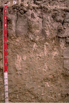 Hypercalcic, Mottled-Subnatric, Grey SODOSOL | |||
|
Location | Kaniva South Road, Lillimur South, western Victoria | |||
|
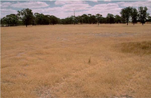
Landform | Plain | |||
|
Geology | Quaternary Lowan Formation: aeolian fine to medium grained dune sand | |||
|
Element | Plain | |||
Horizon | Depth (cm) | Description | ||
A1 | 0–10 | Very dark greyish brown (10YR3/2); light fine sandy loam; pH 6.1: | ||
A2 | 10–12 | Conspicuously bleached hard setting sand that tends to occur in patches, as domed capping on top of columnar subsoil structure: | ||
B21 | 12–30 | Light greyish brown (10YR6/2) with a few faint brownish yellow mottles; medium clay (sandy); strong very coarse columnar structure; very strong consistence when dry (completely dispersive); pH 8.6: | ||
B22 | 30–50 | Very pale brown (10YR7/3) with a few faint yellow mottles; medium clay (sandy); strong very coarse columnar structure; strongly dispersive; pH9.3: | ||
B23 | 50–100 | Very pale brown (10YR7/3) with yellow and reddish yellow mottles; medium clay (sandy); many soft calcareous segregations and very few hard calcareous nodules; completely dispersive; pH 10: | ||
B24 | 100–190+ | Light grey (5Y7/2); medium clay (sandy); moderate coarse polyhedral structure; smooth ped-fabric; few soft and hard calcareous segregations; manganese flecks occur at depth; pH 9.9. | ||
| Management Considerations | ||||
| ||||
Horizon | Depth (cm) | pH (water) | pH (CaCl2) | EC dS/m | NaCl % | Exchangeable Cations cmol-/kg | Wilting Point (pF4.2) | Coarse Sand % | Fine Sand % | Silt % | Clay % | |||
Ca | Mg | K | Na | |||||||||||
A1 | 0–10 | 6.1 | 5.1 | 0.09 | 2.4 | 1.7 | 0.5 | 0.5 | 8.4 | 26.1 | 48.4 | 3.5 | 15 | |
A2 | 10–12 | 15.3 | ||||||||||||
B21 | 12–30 | 8.6 | 7.7 | 0.16 | 6.7 | 6.9 | 1.3 | 1.9 | 15.5 | 20.5 | 37.6 | 3 | 34 | |
B22 | 30–50 | 9.3 | 8.4 | 0.22 | 7.4 | 7.5 | 1.3 | 2.4 | 23.4 | 36.8 | 2 | 30.5 | ||
B23 | 50–100 | 10 | 9 | 0.52 | 1.5 | 8.4 | 1.1 | 7.1 | ||||||
B24 | 100–190+ | 9.9 | 9 | 0.47 | <0.05 | |||||||||