Victorian Resources Online (archived)
LSWW20
| 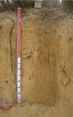 Basic, Arenic, Orthic TENOSOL | |||
|
Location | Nhill-Harrow Road, Little Desert National Park, western Victoria | |||
|
Landform | Dune | |||
|
Geology | Quaternary Lowan Formation: aeolian fine to medium grained dune sand | |||
|
Element | Duneslope | |||
Horizon | Depth (cm) | Description | ||
Ap | 0–20 | Dumped material. | ||
A | 20–40 | Light yellowish brown (2.5Y6/4); sand; minor organic matter content; weak consistence when dry; pH 5.6. | ||
B21 | 40–120 | Brownish yellow (10YR6/8); sand; very weak consistence; pH 5.6. | ||
B22 | 120–170+ | Yellow (10YR7/8); sand; very thin irregular silcrete laminations; very weak consistence; pH 5.6. | ||
| Management Considerations | ||||
| ||||
Horizon | Depth (cm) | pH (water) | pH (CaCl2) | EC dS/m |
Ap | 0–20 | 8.8 | 7.9 | 0.29 |
A | 20–40 | 5.6 | 4.6 | <0.05 |
B21 | 40–120 | 5.6 | 4.4 | <0.05 |
B22 | 120–170+ | 5.6 | 4.4 | <0.05 |