Victorian Resources Online (archived)
LSWW22
| 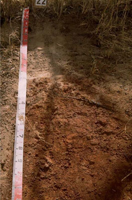 Ferric, Subnatric, Red SODOSOL | |||
|
Location | Harrow, western Victoria | |||
|
Landform | Rise | |||
|
Geology | Cainozoic eluvial: duricrust, ferricrete developed on various rock types | |||
|
Element | Hillslope | |||
Horizon | Depth (cm) | Description | ||
A11 | 0–30 | Brown (10YR4/3); sand (organic); massive (structureless); very weak consistence when dry; pH 5.8: | ||
Ap | 30–45 | Uncemented discontinuous nodular ferricrete and manganiferous pan; brown (7.5YR4/3); sand; massive (structureless); very weak consistence when dry; abundant ferromanganiferous nodules; pH 6.1: | ||
B21 | 45–150+ | Dusky red (2.5YR4/4); light medium clay; strong medium polyhedral, parting to strong fine subangular blocky structure; pH 6.7. | ||
| Management Considerations | ||||
| ||||
Horizon | Depth (cm) | pH (water) | pH (CaCl2) | EC dS/m |
A11 | 0–30 | 5.8 | 4.7 | <0.05 |
A12c | 30–45 | 6.1 | 4.8 | <0.05 |
B21 | 45–150+ | 6.7 | 5.6 | 0.2 |