Victorian Resources Online (archived)
LSWW30
|
| LSWW30 | 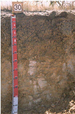 Eutrophic, Mesonatric, Grey SODOSOL | |
|
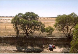
Location | Chappel Road, Telopea Downs, western Victoria | |||
|
Landform | Gently undulating plains | |||
|
Geology | Quaternary Woorinen Formation: aeolian dune sand, calcareous clay | |||
|
Element | Swale/depression | |||
Horizon | Depth (cm) | Description | ||
A1 | 0–10 | Dark greyish brown (10YR4/2); organic sandy loam; weak medium subangular blocky structure; firm consistence (dry); pH 6.7: | ||
B21 | 10–30 | Greyish brown (10YR5/2) with common faint brownish yellow mottles; medium clay; strong fine polyhedral structure; strong consistence (dry); pH 7.2: | ||
B22 | 30–50 | Brownish yellow (10YR6/6) with a few distinct orange mottles; medium heavy clay; strong medium and coarse polyhedral structure; pH 8.7: | ||
C | 50–100+ | Pale mottled sandy material. | ||
| Management Considerations | ||||
| ||||
Horizon | Depth (cm) | pH (water) | pH (CaCl2) | EC dS/m | NaCl % | Exchangeable Cations cmol-/kg | Coarse Sand % | Fine Sand % | Silt % | Clay % | |||
Ca | Mg | K | Na | ||||||||||
A1 | 0–10 | 6.7 | 5.8 | 0.16 | 4.2 | 4.8 | 0.9 | 0.9 | 0.3 | 36.4 | 32.5 | 3.5 | 21 |
B21 | 10–30 | 7.2 | 6.5 | 0.53 | 0.12 | 6.8 | 13 | 0.6 | 4.6 | 18.2 | 17.9 | 2 | 53.5 |
B22 | 30–50 | 8.7 | 8.2 | 1.3 | 0.26 | ||||||||
C | 50–100+ | ||||||||||||