Victorian Resources Online (archived)
LSWW66
Location: Morea
General Landscape Description: Plain. This unit forms the intermittent swamps that typically dry summer. The swamps dry to varying degrees, some totally while others still have signs of a perched watertable close to the surface. This particular soil description is taken from the edge of the swamp and the perched watertable recedes over the drier months. The soils developed on the swamp bed is variable, with some swamps having deeper sand deposition over the clay compared with this description.
Site Description: Swamp
Horizon | Depth (cm) | Description | ||
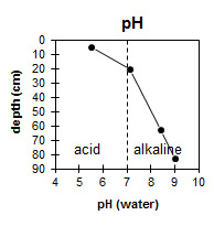
A1 | 0–10 | Brown (7.5YR5/4); sand; pH 5.5; abrupt change to: | ||
B21 | 10–30 | Grey (10YR5/1); medium heavy clay (fine sandy); structured; contains some oxidised root channels; pH 7.1; diffuse change to: | ||
B22 | 30-50 | Dark grey, with a few mottles; medium heavy clay (fine sandy); weak structure; contains a few oxidised root channels; clear change to: | ||
B23 | 50-75 | Dark grey, with a few mottles; medium heavy clay (fine sandy); apedal massive structure; contains a few oxidised root channels; pH 8.4; clear to gradual change to: | ||
B24 | 75-90 | Grey (10YR6/1); clay (fine sandy); structured; calcium carbonate is abundant at greater than 90 cm; pH 9.0. | ||
Key Profile Features:
- Acidic topsoil and alkaline subsoil at depth.
- Poorly drained B21.
- Presence of fine sand in the subsoil may indicate the subsoil cracks on drying.
- Oxidised roots indicate waterlogging.
- Grey colour of the subsoil indicates the clay is undergoing anaerobic conditions (lack of oxygen) for many months of the year.
- Calcium carbonate occurring at depth.
Soil Profile Characteristics:
pH | Salinity Rating | |
Surface (A1 horizon) | Strongly Acid | Low |
Subsoil (B21 horizon) | Slightly Alkaline | Low |
Deeper Subsoil (at 75-90 cm) | Strongly Alkaline | Low |
Chemical and Physical Analysis:
Horizon | Sample Depth (cm) | pH (water) |
A1 | 0-10 | 5.5 |
B21 | 10-30 | 7.1 |
B22 | 30-50 | |
B23 | 50-75 | 8.4 |
B24 | 75-90 | 9.0 |
Profile Described By: Nathalie Baxter (1995).