Victorian Resources Online (archived)
TOPCROP2
Location: Arkona
Australian Soil Classification: Hypercalcic, Mesonatric, Red SODOSOL
General Landscape Description: Rise on a gently undulating plain.
Site Description: Cropping Paddock (lentils 2002, barley 2001).
Geology: Quaternary deposits (Woorinen Formation).
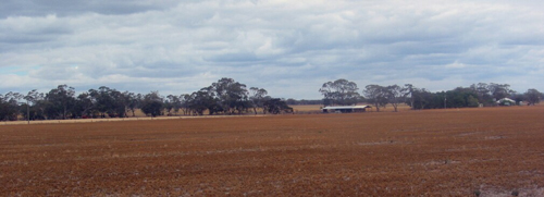
| TOPCROP1 Landscape |
Soil Profile Morphology:
Surface Soil
| Ap | 0-14 cm | Dark brown (10YR3/3); soft surface condition; sandy loam; weakly structured; firm consistence dry, stronger consistence at base of horizon; pH 8.1; sharp change to: | 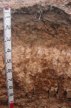 TOPCROP2 Profile |
| Subsoil | |||
| B21 | 14-35 cm | Yellowish red (5YR5/6) and light yellowish brown (10YR6/4); heavy clay; moderate to strong coarse blocky structure; strong consistence dry; pH 8.7; clear change to: | |
| B22k | 35-80 cm | Reddish yellow (5YR6/6); light medium clay; moderate coarse blocky, parting to moderate coarse to medium polyhedral structure; many (40%) soft calcareous segregations; pH 9.4: | |
| B23 | 80-120 cm | Yellowish red (5YR5/8) and light yellowish brown (10YR6/4); medium clay; strong very coarse prismatic, parting to moderate coarse blocky structure; strong consistence dry; manganese flecks; pH 8.0. | |
Key Profile Features:
- Strong texture contrast between surface (A) horizons and subsoil (B21) horizon.
Soil Profile Characteristics:
pH | Salinity Rating | |||
Surface (A1 horizon) | Moderately Alkaline | Medium | Sodic | None1 |
Subsoil (B21 horizon) | Strongly Alkaline | Medium-High | Strongly Sodic | Complete |
Deeper Subsoil (at 90+ cm) | Moderately Alkaline | Extremely High | Strongly Sodic | Slight |
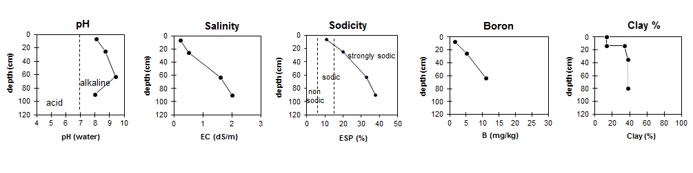
| The surface is moderately alkaline. The subsoil is strongly alkaline becoming moderately alkaline with depth. | The upper subsoil has a medium to high salinity rating becoming very high with depth. | The surface is sodic. The upper subsoil is strongly sodic becoming very strongly sodic with depth. | Boron increases with depth. | Clay content increases markedly at the surface/ subsoil horizon boundary. |
Chemical and Physical Analysis:
Horizon | Horizon Depth (cm) | pH (water) | pH (CaCl2) | EC dS/m | NaCl % | Organic Carbon % | Nitrogen % | Boron mg/kg | Exchangeable Cations | Field Capacity pF2.5 | Wilting Point pF4.2 | Coarse Sand (0.2-2.0mm) | Fine Sand (0.02-0.2mm) | Silt (0.002-0.02mm) | Clay (<0.002mm) | |||
Ca | Mg | K | Na | |||||||||||||||
Meq/100g | ||||||||||||||||||
Ap | 0-14 | 8.1 | 7.6 | 0.23 | 0.86 | 0.07 | 1.6 | 7.0 | 3.1 | 0.44 | 1.2 | 12.3 | 6.2 | 45.7 | 35.4 | 4.0 | 13.0 | |
B21 | 14-35 | 8.7 | 7.9 | 0.51 | 0.07 | 5.2 | 6.6 | 8.5 | 0.6 | 3.9 | 30.7 | 15.6 | 37.8 | 22.4 | 3.0 | 34.0 | ||
B22k | 35-80 | 9.4 | 8.7 | 1.6 | 0.28 | 11 | 3.2 | 12 | 1.0 | 7.9 | 35.9 | 20.1 | 23.5 | 16.6 | 3.0 | 37.5 | ||
B23 | 80-100 | 8.0 | 7.6 | 2.0 | 0.35 | 1.9 | 12 | 1.0 | 8.9 | 35.6 | 19.9 | |||||||
Management Considerations:
Surface (A) Horizons
- In general, management strategies for all soils should aim to increase organic matter levels in the surface soil; minimise the degradation of soil aggregates and porosity; promote the development of stable biopores; improve the calcium status of the ion exchange complex (particularly when sodium is a significant part), and break up any hardpans. Less frequent tillage; using less aggressive implements, and working the soil at optimum moisture conditions can all assist in maintaining soil aggregation and porosity as well as reducing the breakdown of organic matter.
- The level of soluble salts becomes extremely high from 35 cm depth. This will restrict the growth of all but salt-tolerant species.
- The subsoil is sodic and dispersive. This will result in restricted root and water movement into the subsoil. Deeper permeability would be improved by the high level of soluble salts (which restricts dispersion).
Profile Described By: Mark Imhof and Brooke Thompson (December 2002)
References:
Cartwright, B., Zarcinas, B.A, and Mayfield, A.H. (1984). Toxic concentrations of boron in a red-brown earth at Gladstone, South Australia. Australian Journal of Soil Research. 22. 261-72.
Hobson, K. (2001). Boron Tolerant Lentils. In On The Pulse pamphlet. NRE. 2001.
Quinlan, J. (2001). Sorting out the Boron Problem. Wimmera Farming & Landcare Newsletter. 19-20.
Rengasamy, P. and Churchman, G.J. (1999). Cation Exchange Capacity, Exchangeable Cations and Sodicity. In: Soil Analysis – An Interpretation Manual. (eds. Peverill, K.I et al). CSIRO Publishing.