Victorian Resources Online (archived)
WCSS5
Location: Longerenong
Australian Soil Classification: Epicalcareous-Endohypersodic, Self-Mulching, Black VERTOSOL
Soil Map Unit: Kalkee Clay.
General Landscape Description: Level plain.
Site Description: Long-term trial site for dryland cropping.
Geology: Quaternary alluvial and aeolian deposits / lacustrine.
Native Vegetation: Sparse stands of remnant Buloke.
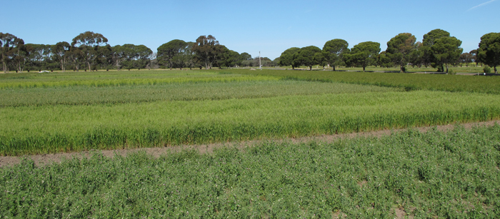
| WWPS5 Landscape |
Soil Profile Morphology:
Surface Soil
| A1 | 0-12 cm | Dark grey (10YR4/1); self-mulching surface condition; light medium clay; moderately calcareous; pH 8.3; clear change to: ; | 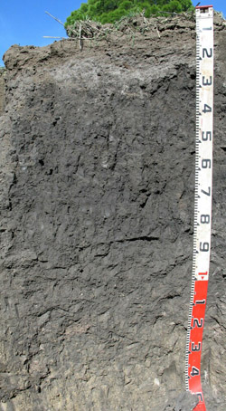 WWPS5 Profile |
| A2 | 12-25 cm | Dark grey (10YR4/1) bleached (10YR6/1 dry); light clay; firm to very firm consistence dry; pH 8.7; clear change to: | |
| Subsoil | | ||
| B21 | 25-45 cm | Very dark grey (10YR3/1); medium heavy clay; strong medium to weak sub-angular blocky structure; strong consistence dry; slightly calcareous; pH 8.6; gradual change to: | |
| B22 | 45-100 cm | Very dark grey (10YR3/1); medium clay; strong very coarse prismatic, parting to strong coarse to medium angular blocky structure; pH 8.7; diffuse change to: | |
| B23 | 100-150 cm | Pale brown (10YR6/3) with very dark greyish brown (10YR3/2); medium heavy clay; strong medium to fine lenticular structure; few (2-5%) soft and semi hard calcareous segregations; slickensides present; pH 8.8. |
Soil Profile Characteristics:
| - | pH | Salinity | |
Surface (A1 horizon) | Moderately Alkaline | Low | None1 |
Subsoil (B21 horizon) | Strongly Alkaline | Low | Moderate2 |
Deeper Subsoil (at 45-100 cm) | Strongly Alkaline | Low | Moderate3 |
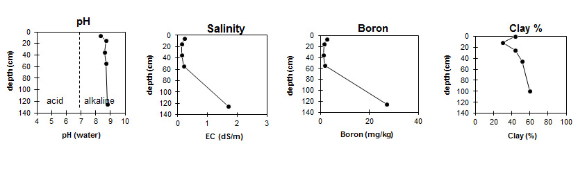
| The surface is moderately alkaline. The subsoil is strongly alkaline. | The salinity rating is low to 1 metre, then increases with depth. | Boron content increases after 60 cm depth. |
|
Chemical and Physical Analysis:
Horizon | Horizon Depth (cm) | pH (water) | pH (CaCl2) | EC dS/m | Sodium Chloride % | Organic Carbon % | Total Nitrogen % | Boron mg/kg | Field Capacity pF2.5 | Wilting Point pF4.2 | Coarse Sand (0.2 - 2.0 mm) | Fine Sand (0.02-0.2 mm) | Silt (0.002-0.02 mm) | Clay (<0.002 mm) |
A1 | 0-12 | 8.3 | 7.8 | 0.24 | 1.2 | 0.088 | 2.7 | 42.43 | 22.16 | 10 | 19 | 17 | 44 | |
A2 | 12-25 | 8.7 | 7.9 | 0.15 | 0.7 | <0.05 | 1.4 | 27.29 | 11.99 | 23 | 31 | 13 | 30 | |
B21 | 25-45 | 8.6 | 7.6 | 0.15 | 0.71 | 1.1 | 41.41 | 19.33 | 18 | 21 | 18 | 44 | ||
B22 | 45-100 | 8.7 | 7.6 | 0.21 | 0.93 | 1.8 | 49.66 | 24.73 | 13 | 16 | 13 | 51 | ||
B23 | 100-150 | 8.8 | 8.4 | 1.7 | 0.274 | 27 | 61.49 | 29.98 | 8 | 16 | 10 | 60 |
Profile Described By: Mark Imhof and David Rees (March 2010).