Victorian Resources Online (archived)
WLRA055
|
| WLRA55 | ||
|
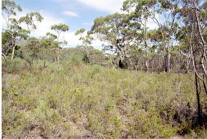
Location | Mount Stapylton, western Victoria | |||
|
Landform | Low hill | |||
|
Geology | Grampians colluvium | |||
|
Element | Hillslope | |||
|
Slope | 35% | |||
|
Aspect | West south west | |||
Horizon | Depth (cm) | Description | ||
A1 | 0–5 | Brown (10YR5/3); loamy sand; weak medium polyhedral structure; rough ped-fabric; weak consistence, dry; water repellent; field pH 5.5; abrupt boundary to: | ||
A2 | 5–20 | Yellowish brown (10YR5/4), conspicuously bleached light grey (10YR7/2 dry); loamy sand; massive (structureless); weak consistence when dry; coarse ferruginous nodules are common; field pH 6.0; gradual boundary to: | ||
B1 | 20–60 | Light grey (10YR6/2) with many coarse distinct brownish yellow (10YR6/6) mottles; silty clay loam, heavy; moderate polyhedral structure; smooth-ped fabric; strong consistence when moderately moist; few coarse ferruginous nodules; field pH 5.5; gradual boundary to: | ||
B21 | 60–90 | Light grey (2.5Y7/2) with many coarse prominent red (2.5YR4/6) mottles; light medium clay; weak polyhedral structure; smooth-ped fabric; very firm consistence when moderately moist; field pH 5.0; clear boundary to: | ||
B22 | 90–115 | Reddish brown (5YR5/4) with coarse distinct light brownish grey mottles common; light clay; massive (structureless); very firm consistence when dry; field pH 4.5; clear boundary to: | ||
B3 | 115–130+ | Light grey (2.5Y7/2) with many prominent coarse dark olive brown mottles; sandy loam; massive (structureless); very few small subangular quartz fragments; very firm consistence when moderately moist; field pH 4.0. | ||
| Management Considerations | ||||
| ||||