Victorian Resources Online (archived)
WLRA131
|
| WLRA131 | 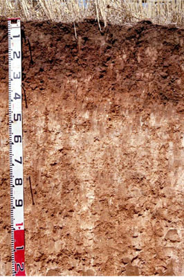 Sodic, Hypercalcic, Red CHROMOSOL | |
|
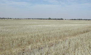
Location | Jeparit Road Peppers Plains, Warracknabeal, Western Victoria | |||
|
Landform | Undulating plain | |||
|
Geology | Quaternary Woorinen Formation: aeolian dune sand, calcareous clay | |||
|
Element | Mid slope | |||
|
Slope | 1% | |||
|
Aspect | South-west | |||
Horizon | Depth (cm) | Description | ||
A11 | 0–5 | Dark brown (10YR3/3); sandy loam; moderate medium to very fine polyhedral structure; rough ped fabric; weak consistence dry; pH 7.7; smooth and abrupt change to: | ||
A12 | 5–15 | Dark brown (7.5YR3/2); loam; massive (structureless); earthy ped fabric; firm consistence, dry; weakly cemented cultivation pan evident; pH 7.5; abrupt and wavy change to: | ||
B21 | 15–35 | Yellowish red (5YR4/5); light medium clay; strong coarse prismatic, parting to medium angular blocky structure; smooth ped fabric; strong consistence dry; contains very few fine manganiferous nodules; pH 8.5; gradual and smooth change to: | ||
B22k | 35–75 | Reddish yellow (7.5YR6/6) with a few faint fine red mottles; light clay; weak coarse polyhedral structure; rough ped fabric; firm consistence, moderately moist; contains very many extremely coarse calcareous soft segregations, very few medium calcareous nodules and argillaceous tubules; pH 9.1; diffuse and smooth change to: | ||
B23k | 75–135 | Reddish yellow (7.5YR7/6); light clay; weak medium to coarse polyhedral structure; rough ped fabric; weak consistence moderately moist; contains many extremely coarse calcareous soft segregations and a few fine manganiferous fragments; pH 9.9. | ||
| Management Considerations | ||||
| ||||
Horizon | Depth (cm) | pH (water) | pH (CaCl2) | EC dS/m | Exchangeable Cations cmol-/kg | |||
Ca | Mg | K | Na | |||||
A11 | 0-5 | 7.7 | 7.3 | 0.19 | 13 | 3.8 | 2 | 0.29 |
A12 | 5-15 | 7.5 | 7.1 | 0.12 | 13 | 4.2 | 1.6 | 0.45 |
B21 | 15-35 | 8.5 | 8 | 0.18 | 15 | 7.7 | 1.6 | 0.98 |
B22k | 35-75 | 9.1 | 8.5 | 0.51 | 8.5 | 12 | 2 | 3.6 |
B23k | 75-135 | 9.9 | 9.4 | 0.66 | 2.6 | 11 | 2.2 | 7.1 |