Victorian Resources Online (archived)
WLRA139
|
| WLRA139 | 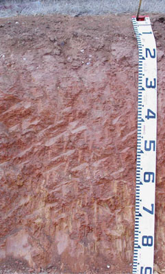 Bleached-Sodic, Eutrophic, Red KANDOSOL | |
|
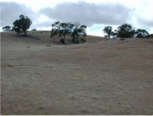
Location | Shays Flat-Malakoff Road, Landsborough, western Victoria | |||
|
Landform | Rolling rises | |||
|
Geology | Palaeozoic (Cambrian) Warrak Formation: marine sandstone, siltstone, schist | |||
|
Element | Hillslope | |||
|
Slope | 6% | |||
|
Aspect | North | |||
Horizon | Depth (cm) | Description | ||
A1 | 0–10 | Brown (7.5YR4/4); loam, fine sandy; weak fine subangular blocky structure; rough ped-fabric; weak dry consistence; many small to medium quartz gravels; pH 5.5; abrupt and smooth boundary to: | ||
A2 | 10–25 | Light brown (7.5YR6/4), bleached ; sandy clay loam; apedal (structureless); very firm dry consistence; many small to medium quartz gravels; pH 6.4; abrupt and irregular boundary to: | ||
B2 | 25–55 | Red (2.5YR4/8) with common distinct orange inclusions of substrate material as mottles; light clay; weak medium subangular blocky structure; rough ped-fabric; strong dry consistence; few medium manganiferous soft segregations and few medium organic root linings; pH 7.1; gradual and irregular boundary to: | ||
BC | 55–85+ | Weathered weakly metamorphosed sediments; field pH 7.0. | ||
| Management Considerations | ||||
| ||||
Horizon | Depth (cm) | pH (water) | pH (CaCl2) | EC dS/m | Exch. Al mg/kg | Exchangeable Cations cmol-/kg | Field Capacity (pF2.5) | Wilting Point (pF4.2) | Coarse Sand % | Fine Sand % | Silt % | Clay % | |||
Ca | Mg | K | Na | ||||||||||||
A1 | 0–10 | 5.5 | 4.8 | <0.05 | <10 | 1.4 | 0.68 | 0.31 | 0.11 | 21 | 5.3 | 16.8 | 53.6 | 16 | 7 |
A2 | 10–25 | 6.4 | 5.8 | 0.08 | <10 | 0.95 | 1 | 0.25 | 0.29 | 18.1 | 6.6 | 14.3 | 51.1 | 15.5 | 15 |
B2 | 25–55 | 7.1 | 6.4 | 0.16 | 0.76 | 3 | 0.39 | 0.95 | 25.2 | 13.4 | 6.1 | 37.2 | 20 | 33 | |