Victorian Resources Online (archived)
WLRA144
|
| WLRA144 | 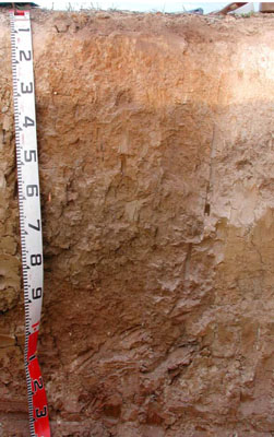 Vertic, Subnatric, Brown SODOSOL | |
|
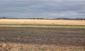
Location | Six Mile Creek, Joel South, western Victoria | |||
|
Landform | Level plain | |||
|
Geology | Quaternary recent alluvium: fluvial gravel, sand, silt | |||
|
Element | Plain | |||
|
Slope | 1% | |||
|
Aspect | West | |||
Horizon | Depth (cm) | Description | ||
A1 | 0–10 | Dark greyish brown (10YR4/2); sandy clay loam; weak very fine subangular blocky structure; rough ped-fabric; weak dry consistence; water repellent; pH 5.0; abrupt and smooth boundary to: | ||
A2 | 10–50 | Conspicuously bleached pale brown; common medium to coarse ferruginous nodules; clear and irregular boundary to: | ||
B1 | 10–30 | Strong brown (7.5YR4/6), with very few fine faint pale brown mottles; light clay; weak fine subangular blocky structure; rough ped-fabric; firm dry consistence; pH 5.3; clear and irregular boundary to: | ||
B21 | 30/50–60 | Yellowish brown (10YR5/6) with a few fine distinct orange and pale brown mottles; heavy clay; moderate fine angular blocky structure; smooth ped-fabric; strong moderately moist consistence; pH 5.8; gradual and smooth boundary to: | ||
B22 | 60–105 | Light olive brown (2.5Y5/4); heavy clay; weak coarse subangular blocky structure; rough ped-fabric; strong moderately moist consistence; few fine to coarse calcareous nodules and soft segregation patches, very few fine manganiferous fragments and nodules; pH 7.5; diffuse and smooth boundary to: | ||
B23 | 105–140+ | Brownish yellow (10YR6/6); medium clay; weak medium subangular blocky structure; rough ped-fabric; strong moderately moist consistence; few coarse to very coarse calcareous soft segregation patches; pH 8.6. | ||
| Management Considerations | ||||
| ||||
Horizon | Depth (cm) | pH (water) | pH (CaCl2) | EC dS/m | NaCl % | Exchangeable Cations cmol-/kg | Field Capacity (pF2.5) | Wilting Point (pF4.2) | Coarse Sand % | Fine Sand % | Silt % | Clay % | |||
Ca | Mg | K | Na | ||||||||||||
A1 | 0–10 | 5.0 | 4.4 | 0.12 | 2.9 | 1.1 | 0.47 | 0.15 | 27.4 | 8.9 | 9.4 | 50.4 | 6.5 | 31 | |
A2 | 10–50 | ||||||||||||||
B1 | 10–30 | 5.3 | 4.6 | 0.1 | 3.6 | 4.5 | 0.49 | 0.37 | 34.9 | 16.5 | 4.2 | 36.8 | 8 | 46.5 | |
B21 | 30/50–60 | 5.8 | 5.0 | 0.13 | 5.4 | 9.7 | 0.64 | 1.1 | 41.1 | 24.7 | 2.2 | 21.3 | 12 | 59 | |
B22 | 60–105 | 7.8 | 6.9 | 0.14 | 6.5 | 12 | 0.58 | 2 | 37 | 21 | 1.1 | 25.4 | 20 | 50.5 | |
B23 | 105–140+ | 8.6 | 8.1 | 0.3 | <0.01 | 7.7 | 13 | 0.6 | 2.6 | 34.2 | 20.1 | 1.4 | 33.1 | 15.5 | 45.5 |