Victorian Resources Online (archived)
WLRA147
| 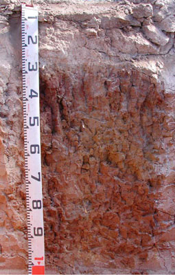 Eutrophic, Mottled-Mesonatric, Brown SODOSOL | |||
|
Location | Potters Road, Joel, western Victoria | |||
|
Landform | Gently undulating rise | |||
|
Geology | Pliocene Parilla Sand: marine sand and silt | |||
|
Element | Rise crest | |||
|
Slope | 1% | |||
|
Aspect | East | |||
Horizon | Depth (cm) | Description | ||
A1 | 0–10 | Brown (7.5YR4/3); sandy loam; massive (structureless); very weak dry consistence; very few fine subrounded quartz gravels; very few fine ferromanganiferous nodules; common fine to very fine roots; pH 5.2; clear and smooth boundary to: | ||
A2 | 10–30 | Yellowish brown (10YR5/4), conspicuously bleached very pale brown (10YR8/2 dry); sandy loam; massive (structureless); weak dry consistence; a few fine to very fine subrounded quartz gravels; few medium ferromanganiferous nodules; a few fine to very fine roots; pH 5.4; abrupt and irregular boundary to: | ||
B21 | 30–50 | Yellowish brown (10YR5/4) with common medium distinct yellowish red (5YR4/6) mottles; medium heavy clay; strong fine prismatic, parting to moderate fine subangular blocky structure; smooth ped-fabric; strong moderately moist consistence; common fine to very fine roots; pH 8.2; clear and tongued boundary to: | ||
B22 | 50–80 | Strong brown (7.5YR5/6); medium heavy clay; moderate fine to very fine prismatic, parting to weak fine to very fine subangular blocky structure; rough ped-fabric; strong moderately moist consistence; few fine to medium manganiferous nodules; few faint slickensides; few fine to very fine roots; pH 8.7; gradual and smooth boundary to: | ||
B23 | 80–110+ | Reddish yellow (7.5YR6/8) with many medium distinct yellowish red (5YR4/6) mottles; medium heavy clay; massive (structureless); strong moderately moist consistence; few fine to medium manganiferous nodules; pH 8.5. | ||
| Management Considerations | ||||
| ||||
Horizon | Depth (cm) | pH (water) | pH (CaCl2) | EC dS/m | NaCl % | Exchangeable Cations cmol-/kg | Field Capacity (pF2.5) | Wilting Point (pF4.2) | Coarse Sand % | Fine Sand % | Silt % | Clay % | |||
Ca | Mg | K | Na | ||||||||||||
A1 | 0–10 | 5.2 | 4.5 | 0.11 | 2.5 | 0.41 | 0.29 | 0.33 | 16.8 | 4.1 | 36.4 | 40.6 | 6 | 12 | |
A2 | 10–30 | 5.4 | 4.8 | <0.05 | 1.5 | 0.3 | 0.08 | 0.07 | 12.6 | 2.3 | 38 | 43.2 | 2.5 | 13.5 | |
B21 | 30–50 | 8.2 | 7.2 | 0.24 | 7.6 | 9.4 | 0.44 | 5.3 | 41 | 22.1 | 8.7 | 24.3 | 6 | 57.5 | |
B22 | 50–80 | 8.7 | 7.9 | 0.31 | 6 | 9.5 | 0.4 | 4.9 | |||||||
B23 | 80–110+ | 8.5 | 7.6 | 0.31 | 0.03 | 3.4 | 8.7 | 0.3 | 5.6 | 31.1 | 13.5 | 17.8 | 39.7 | 8 | 32 |