Victorian Resources Online (archived)
WP4
Location: Longeranong
Australian Soil Classification: Endohypersodic, Epipedal, Grey VERTOSOL
Northcote Factual Key: Ug 5.2
Great Soil Group: grey, brown and red clays
Local Soil Type Name: Murtoa Clay
General Landscape Description: Western edge of River Frontage Landscape Unit (also adjacent to Prior Stream Floodplain Landscape)
Site Description: Local drainage line.
Geology: Late Pleistocene to Holocene alluvial and aeolian deposits (Woorinen Formation).
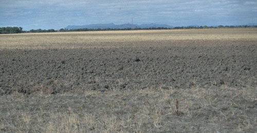 WP4 Landscape |
Soil Profile Morphology:
Surface Soil
| A1 | 0-10 cm | Dark greyish brown (10YR4/2); heavy clay; surface cracking present; moderate medium angular blocky structure; strong consistence dry; pH 6.6; clear change to: | 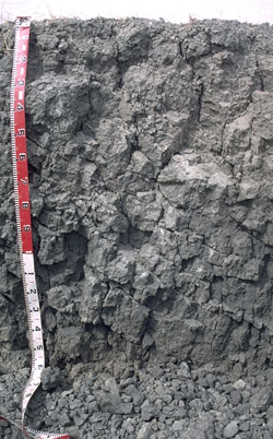 WP4 Profile |
NOTE: A thin discontinuous A2 horizon may occur at the interface with the B21 horizon. This has faint sporadic bleaching and is light medium clay in texture. | |||
| Subsoil | |||
| B21 | 10-30 cm | Grey (10YR5/1); heavy clay; moderate very coarse prismatic, parting to blocky structure; strong consistence dry; pH 7.5; gradual change to: | |
| B22 | 30-80 cm | Grey (10YR5/1); heavy clay; slickensides present; strong consistence dry; pH 7.3; gradual change to: | |
| B23 | 80-130 cm | Grey (10YR5/1); heavy clay; slickensides present; very strong consistence dry; pH 7.4; gradual change to: | |
| B24 | 130-160 cm | Grey (10YR5/1) with diffuse greyish brown (2.5Y5/2) mottles; heavy clay; strong very coarse prismatic structure; slickensides present; strong consistence moist and sticky when wet; pH 7.3. | |
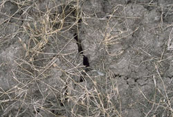
WP4 Surface cracking.
Key Profile Features:
- High clay content throughout soil profile.
- Surface cracking when dry.
- Vertic properties (ie. significant shrink-swell characteristic).
| - | pH | Salinity | ||
Surface (Ap horizon) | Slightly Acid | Very Low | Non-Sodic | None 1 |
Subsoil (B21 horizon) | Slightly Alkaline | Very Low | Sodic | Strong |
Deeper Subsoil (at 1.3 metres) | Slightly Alkaline | Medium | Strongly Sodic | Strong-Complete |
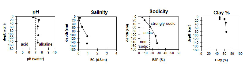
| The surface is slightly acid. The subsoil is slightly alkaline. | The salinity rating is very low up until 80 cm depth and becomes medium in the deeper subsoil. | The surface is non-sodic. The subsoil is sodic becoming strongly sodic at 50 cm. |
|
Chemical and Physical Analysis:
Horizon | Horizon Depth (cm) | pH (water) | pH (CaCl2) | EC dS/m | Exchangeable Cations | |||
Ca | Mg | K | Na | |||||
meq/100g | ||||||||
A1 | 0-10 | 6.6 | 5.9 | 0.15 | 8.8 | 7.5 | 1.6 | 0.95 |
B21 | 10-30 | 7.5 | 6.2 | 0.07 | 10 | 10 | 1.3 | 1.8 |
B22 | 30-80 | 7.3 | 6.5 | 0.36 | 8.4 | 11 | 4.1 | 4.1 |
B23 | 80-130 | 7.4 | 6.8 | 0.93 | 9.3 | 12 | 7.4 | 7.4 |
B24 | 130-160 | 7.3 | 6.7 | 0.87 | 8.2 | 12 | 7.7 | 7.7 |
Horizon | Horizon Depth (cm) | Oxidisable Organic Carbon % | Total Nitrogen % | Sodium Chloride % | Wilting Point pF4.2 | Coarse Sand (0.2-2.0 mm) | Fine Sand (0.02-0.2 mm) | Silt (0.002-0.02 mm) | Clay (<0.002 mm) |
A1 | 0-10 | 1.4 | 0.1 | 16.7 | 10 | 23 | 15 | 47 | |
B21 | 10-30 | 20 | 5 | 14 | 16 | 60 | |||
B22 | 30-80 | <0.05 | 21.3 | 3 | 11 | 18 | 63 | ||
B23 | 80-130 | 23 | 1 | 9 | 20 | 65 | |||
B24 | 130-160 | 0.11 |
Management Considerations:
Whole Profile
- Plant available water capacity (PAWC) is considered to be moderate (estimated at 120 mm). This is based on available laboratory data and assumes an effective rooting depth of 80 cm. Effective rooting depth will be restricted by the strongly sodic deeper subsoil and the moderate level of soluble salts. The availability of moisture to the plant will depend to a large degree, however, on soil structure and consistence. In dense and coarsely structured subsoils such as these, it is likely that there will be a large amount of unused ‘available’ moisture at depth in the subsoil.
Surface (A) Horizon
- When the soil is dry, heavy rains will move down soil cracks. This rapid recharge can be valuable for the survival of plants near wilting. When wet, the soil will swell and further infiltration of water will be relatively slow. Large cracks can also be disadvantageous in that they enhance soil moisture evaporation and provide protection for pests (e.g. crickets, mice).
- Tillage of cracking clay soils should be avoided if the soil is wet (ie. wetter than the plastic limit). At such moisture conditions, excessive tillage, trafficking or overstocking can result in structural degradation (eg. compaction, smearing) occurring. Ideally, tillage should take place on clay soils such as these when the soil is drier than the plastic limit down to at least the tillage depth. [See Appendix A for information on clay compaction (page A-20) and plastic limit (page A-31)].
- The surface soil is non-sodic but disperses completely after remoulding. This indicates that tillage or over-stocking of the soil whilst in a moist to wet condition may result in structural degradation (eg. surface sealing, increased cloddiness) occurring. Raindrop action on bare soil may have a similar effect, so it is important to maintain surface cover. Gypsum application may assist in improving surface soil structural condition on such soils.
Subsoil (B) Horizons
- The level of soluble salts is low in the upper subsoil and becomes medium from approximately 80 cm depth. These levels of soluble salts are only likely to significantly restrict the growth of deep rooted salt sensitive species.
- The dense and coarsely structured upper subsoil is sodic and strongly dispersive. This will result in restricted root and water movement. The deeper subsoil (below 50 cm depth) becomes strongly sodic and dispersive. The exchangeable calcium to magnesium ratio is also low (< 1) in the deeper subsoil.
- The subsoil displays strong vertic properties which indicates that significant shrinking and swelling occurs with wetting and drying cycles. This may disturb roots of some plant species and has engineering implications (eg. disturbance to building foundations and fencelines).