- The most fertile part of the soil profile (topsoil) is also the most prone to erosion
- Rates of erosion vary with soil type and with past land use practices
|
- Erosion can be reduced by effective land management practices based on building and maintaining ground cover
- Considerable efforts have been made over the past 60 years to rehabilitate many area of regional erosion with reasonable success
|
Understanding the problem
|
| Why is it important to me as a farmer?
|
- Soil erosion - by water or wind - is costly, with impacts on natural and built assets
including infrastructure, water quality, biodiversity and in some cases, human safety
- It occurs because soils have not been protected from the forces of wind, raindrop impact
or running water in sheets, rills, gullies or tunnels
- Erosion by water is the more important form of erosion in the Corangamite region.
As of 2010 there were 7268 mapped erosion sites in the region. There may be many
more incipient or potential soil erosion that have not yet been identified
|
- Its major impact on farming includes: loss of valuable topsoil containing nutrients,
altering drainage patterns and reducing capacity of dams via sedimentation
- The top 10cm of most soils is particularly rich and contains most of the soil'snutrients,
plant roots and living organisms (bacteria, fungi, protozoa, nematodes, earthworms and
other soil animals). It is this part of the soil profile that is particularly at risk to erosion
|
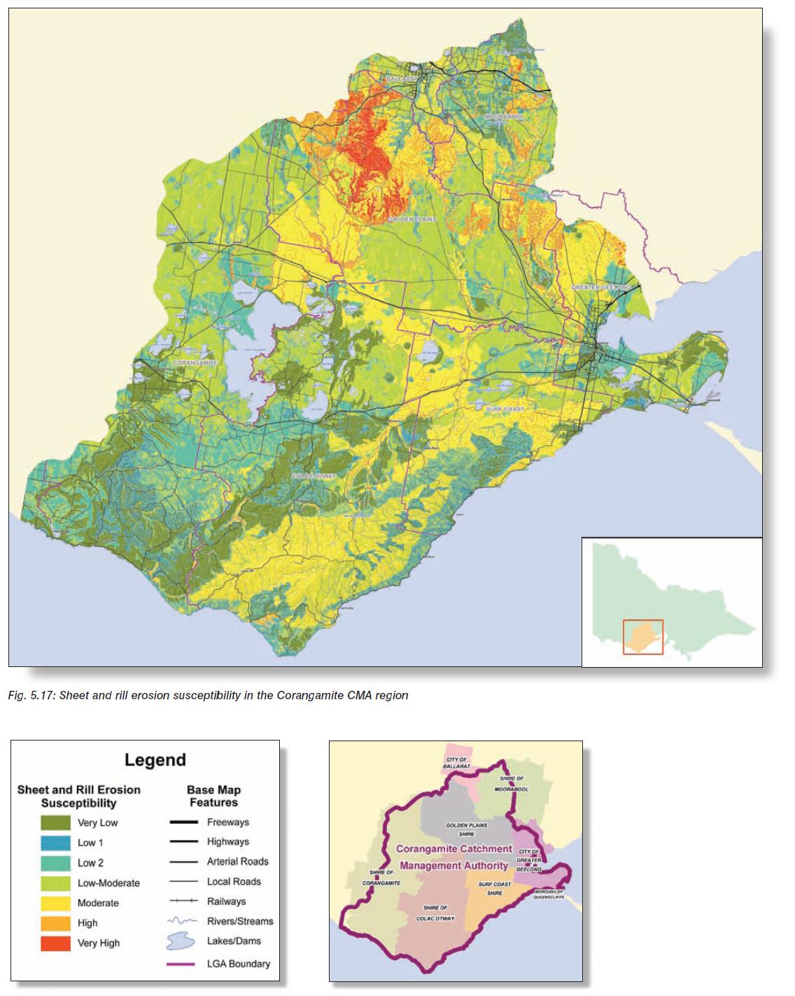
Figure 1 : Sheet and rill erosion susceptibility in the Corangamite region. Figure 1 : Sheet and rill erosion susceptibility in the Corangamite region
[View larger image]
|
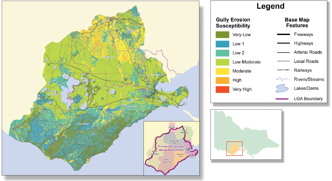
Figure 2 - Gully erosion susceptibility in the Corangamite region. : Figure 1 : Sheet and rill erosion susceptibility in the Corangamite region
[View larger image]
Mapped erosion in the Corangamite region -
Interactive mapping hosted by UB Spatial (Unversity of Ballarat / CeCC)
|
- Soil erosion is the detachment, transportation and deposition of soil by water or wind
- Eroded soil in transport is 'sediment'; sedimentation occurs when sediment is deposited
- Water erosion is usually classified into stages corresponding with progressive
concentration of surface run-off. These include:
- Splash Erosion: The first and most important stage in the erosion process is the
impact of the raindrop
- Sheet Erosion - is the planar removal of surface soil by the action of either
raindrop splash, shallow flows of surface of water, or even by wind
|
- Rill Erosion - the formation of gutters or miniature gullies by the action of run-off
water concentrating into small rivulets
- Gully Erosion - the formation of steep sided channels by concentrated run-off
Gullies often have more or less vertical heads and are cut into sub-soil or
overlying rock
- Tunnel Erosion - the formation of underground channels or pipes through the
removal of (dispersible) subsoil by seepage water
|
| How to recognise it in the paddock
|
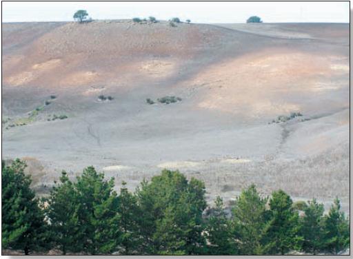
Figure 3 - Sheet erosion. - Source: CCMA Soil Health Training Manual (2008)
Sheet erosion on steep hills removes the topsoil and plant nutrients and develops a hard
impermeable surface which increases the rate of runoff creating further erosion problems
down slope
- Although widespread, sheet/rill erosion is not as visually obvious as other forms
of erosion. The most noticeable sheet erosion occurs on slopes where intensive
horticulture or cropping is the dominant land use, such as north of Ballarat, where
steep slopes are present. Where the slopes are sufficient and the soil properties
allow, sheet erosion has developed into rills, which may further develop into gully
erosion. Examples include the area near Birregurra, locally known as 'the
washaways', and in the Murroon district (Dahlhaus 2003)
|
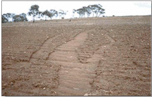
Figure 4 : Rill erosion, - Source: CCMA Soil Health Training Manual (2008)
Rill erosion in a paddock situation can create problems with paddock trafficability and
concentrates water flow which increases velocity and leads to formation of gullies if
unattended.
|
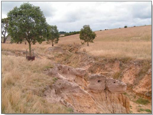
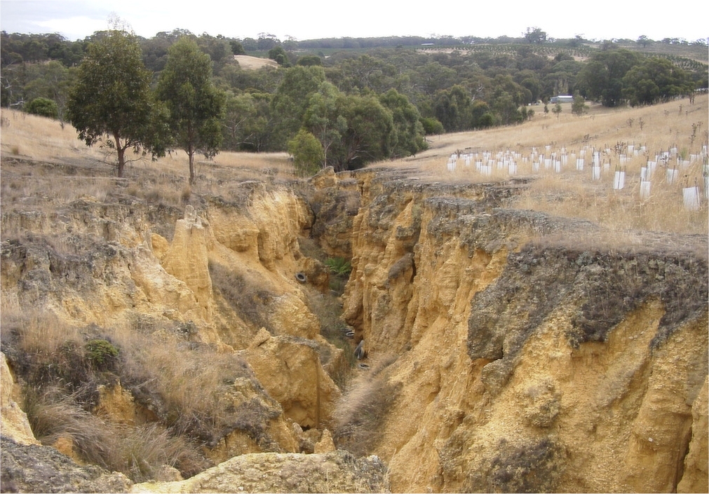
Figure 5 - Gully erosion. - Source: CCMA Soil Health Training Manual (2008)
Gully erosion in a paddock situation can cause disruption to cultivation, stock
movement and general access across the paddock. Sediment from the gully can
impact on public utilities such as roads and bridges
- Gully erosion is the ultimate result of both tunnel and rill erosion. Gullies are the
most visually obvious representation of erosion in the landscape and have been
the most common target for rehabilitation in the past. Spectacular examples of
gully erosion are found near Elaine and Clifton Springs. Other areas where gully
erosion is known to be prevalent include Dereel, Rokewood, Linton, Lismore and
Irrewillipe. In many areas, gully erosion is a legacy of past land use, particularly
gold mining along creeks and as a result of intense rainfall events after drought.
Considerable efforts have been made over the past 60 years to rehabilitate many
of these areas, with reasonable success (Dahlhaus 2003).
|
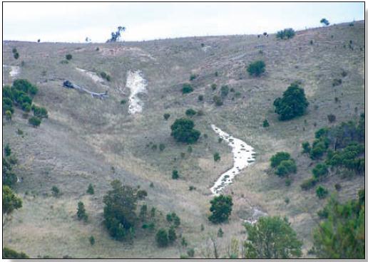
Figure 6 : Tunnel erosion. - Source: CCMA Soil Health Training Manual (2008)
The first sign of tunnel erosion is yellow clay emanating from pop-holes or formation
of silt fans. The final stage is the collapse of the tunnel and formation of a gully.
down slope
- Tunnel erosion is particularly prevalent in the weathered Otway Group rocks of
lower Cretaceous age (i.e. the Eumeralla Formation). The erosion impacts on
agricultural land and water with substantial area developing along drainage lines
in the steeper, cleared landscapes of Wild Dog Creek valley, Barham River
valley, Smythe Creek valley and Wongarra.
|
| What is the best practice?
|
- The rate of erosion depends on the climate, soil, topography, plant cover and land use.
As such, management principles vary with guidance offered in the table below:
|
|
Table 1 - Basic Principles for erosion control. - Source: CCMA Soil Health Training Manual (2008)
|
| |
Principles |
Treatment |
| |
Reduce erosivity of water |
| |
Reduce run-off volume |
- Provide for increased number of disposal points
- Treat catchment area with vegetation to slow down run-off and allow more infiltration. e.g. deep-rooted grasses
|
| |
Reduce velocity of run-off and flow |
- Increase number of diversion banks to spread surface flow more often
- Provide broader disposal points. The wider the disposal area, the slower the velocity
- Increase friction to flow by introducing vegetation
- Increase width of disposal area to spread volume of flow over greater area
- Install gradient control structures in drainage lines to collect sediment and reduce gradient
|
| |
Reduce erodibility of soil |
| |
|
- Bare soil will erode more than grass-covered soil. Sow disposal area to suitable grass species
- Treat dispersible soils with gypsum prior to sowing
- Construct non-vegetative structures to dissipate energy of flowing water
|
| |
Treat dispersible soils |
| |
Reduce tunnel erosion |
- Deep rip along line of tunnel to ensure floor of tunnel is reached. Follow this by ripping across slope to prevent concentration of flow in rip lines down slope. Spread gypsum to stabilise soil, sow to deep-rooted perennials. Best to construct eye-brow bank above treated area to divert surface flow until area is stabilised.
|
| |
|
| How can you achieve this?
|
- Sheet Erosion:
- The primary requirement to avoid sheet erosion is to build and maintain
vegetative cover of the soil and ensure the maintenance of high infiltration rates
of water into the soil profile
- Gully Erosion:
- Gully erosion is often driven by associated land degradation in the catchment to
the gully system. This may be due to overgrazing or inappropriate cultivation
causing intense runoff events. Management for prevention will maintain high
levels of vegetative cover and keep soil infiltration capacity at the optimum
- To be effective, gully control needs to be tackled in two ways: by fixing the
problems in the catchment and by stabilising the gully itself
- Stabilisation of an eroding gully aims to divert and modify the flow of water
moving into and through the gully so that scouring is reduced, sediment
accumulates and revegetation can proceed. A variety of options can be used to
get the water safely from the natural level to the gully floor. Improvements such
as grass chutes, pipe structures, rock chutes or drop structures can be installed
to do this effectively
|
- As with other forms of erosion, prevention is better than cure. In most cases
gullies can be prevented by good land management practices aimed at
maintaining even infiltration rates and a good plant cover
- Strategies for preventing gully erosion include:
- maintaining remnant vegetation along drainage lines and eliminating
grazing from these areas
- increasing water usage by planting deep-rooted perennial pastures, trees,
or an appropriate mixture of both thus maintaining healthy, vigorous levels
of vegetation
- identifying drainage lines as a separate land class in which vegetation
needs to be protected
- immediate stabilisation of sheet or rill erosion
- vermin control
- ensuring run-off from tracks is evenly distributed across paddocks to
dissipate its energy
- maintaining high levels of organic matter in the soil
- avoiding excessive cultivation
|
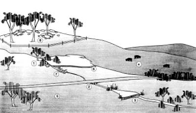
Figure 7 - Farm management techniques to prevent gully erosion. - Source: DEPI Victoria
[View larger image]
- Retain remnant vegetation along gullies and areas of recharge
- Maintain tracks and culverts to minimise the erosive power of runoff water
- Dam gullies to control flow with due consideration to spillways
- Ensure a suitable stocking rate so that pasture is not damaged
- Establish and maintain vigorous deep rooted perennial pastures
- Divert water away from erosion prone areas using diversion banks
- Build gully structures to reduce the force of water
- Fence and manage the land according to its capability
|
- Tunnel Erosion:
- A key part of the management of tunnel prone areas is to maximise vegetative
cover. It is also useful to modify clay dispersion in the profile, perhaps requiring
the use of gypsum
- Some gully and tunnel erosion sites have been rehabilitated within the Corangamite
region. Works conducted have included:
- the construction of diversion banks and rock chutes
- battering of banks and stabilising sites with vegetation. Rabbit control prior to
works is essential
- Results from erosion remediation in the Corangamite region have been good, if ongoing
maintenance has been carried out. Whole farm planning courses have been conducted
for private landholders throughout the Corangamite region over the past 20 years. These
courses encouraged landholders to fence paddocks according to land capability. This
process decreases the threat of erosion and improves long-term agricultural productivity.
Currently, less than 5% of the Corangamite region is fenced according to land classes
|
Management Strategies for Grazing
- Any erosion problem on grazing land almost always starts with a break in pasture cover.
The most common causes of erosion on pastures are overgrazing and high wear in
specific areas. Erosion risks intensify on steep land, in areas with soils of high erosivity,
and in areas with a lot of stock movement such as cattle tracks
- A good land manager will have a sound understanding of the impact of stocking rates
and grazing techniques on soil and be able to respond to changing conditions
- Management approaches used to avoid erosion include:
- Maintain healthy pastures
- Encourage plant roots
- Match stock numbers to pasture availability
- Rest pastures from grazing
- Minimise compaction
- Fence paddocks according to credibility
- Have several shaded areas
- Prevent stock tracks forming
- Reduce the impact of dairy cattle movements
- Manage weeds carefully
- Slash rather than burn
- Minimise cultivations when improving pastures
- De-stock in drought
|
Management Strategies for Cropping
- The main considerations when controlling erosion in cropping paddocks are slope,
management of water flow within individual paddocks and farm/paddock management
practices. Croppers need to know where the water flows, the location of steep slopes
and permanent and intermittent watercourses, and the slope and erosion risk of both
individual paddocks and the farm. With this information they can determine row direction
and length and design and locate headlands and access tracks to minimise erosion
- Management approaches used to avoid erosion in cropping include:
- Maintain groundcover through stubble retention
- Consider green manure crops for summer soil cover
- Build organic matter in soils, consider a pasture phase in the cropping cycle
- Avoid bare fallow
- Use cultivation sparingly
- If cultivating, ensure soil is at correct moisture content and tillage equipment is appropriate
- Avoid cultivating through natural drainage lines
- Avoid cultivating steep slopes
- Avoid cultivating for weed control
- Manage water flow through paddocks
- Maintain natural watercourses
- Keep paddock access in good condition
- Use banks to slow water flow
|
Other related questions in the Brown Book
|
|
Brown Book content has been based on published information listed in the Resources and References sections below
|
- Soil Erosion Training Manual. Department of Primary Industries, Victoria on behalf of the Corangamite Catchment Management Authority (2008).
- Healthy Soils, Module 6. - Making more from sheep - MLA.
|
- Clarkson T, Department of Primary Industries on behalf of the Corangamite Catchment
Management Authority (2007). Corangamite Soil Health Strategy 2007. Corangamite
Catchment Management Authority, Colac, Victoria.
|
|