Victorian Resources Online (archived)
Soil/Landform Unit 62
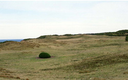 Large parts of this soil-landform unit at Cape Otway have been cleared and provide rough grazing for cattle on native grasses |
0.36% of CMA region In the vicinity of Cape Otway and extending discontinuously to the west is an elevated plain of coastal dunes. The coastal margins of the plain are generally fronted by 100 m cliffs of calcarenite with possibly small primary dunes at the base of the cliffs. Behind the cliffs, the plain has an irregular dune topography that may extend several kilometres inland. The demarcation to other land systems is very sharp and easily defined. Woodlands of Eucalyptus viminalis with open grassy understoreys used to cover most areas, although shrubs resistant to salt and sand-laden winds formerly colonised the coastal localities. Most areas have been cleared for grazing, but the establishment of improved pastures presents difficulties. Overgrazing has resulted in severe wind erosion in some areas, and reclamation is difficult and expensive. | 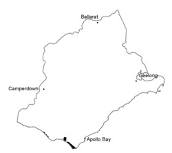 |
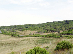 Tussock grassland with a richly diverse heath stratum |  |
 | 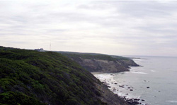 Calcarenite cliffs at Cape Otway |
Component | 1 | 2 | 3 | 4 | 5 | 6 |
Proportion of soil-landform unit | 6% | 4% | 20% | 20% | 10% | 40% |
| CLIMATE Rainfall (mm) | Annual: 900-1100, lowest January (45), highest July (105) | |||||
| Temperature (oC) | Annual: 14, lowest July (10), highest February (18) | |||||
| Seasonal growth limitations | Temperature: less than 10oC (av.) July Precipitation: less than potential evapotranspiration late November-February | |||||
| GEOLOGY Age and lithology | Recent sand and shell grit on Neogene calcarenite basement | |||||
| Geomorphology | ||||||
| LANDUSE | Cleared areas: Beef cattle grazing on unimproved patures; mining of calcarenite; residential; active recreation Uncleared areas: Forest grazing of beef cattle; active and passive recreation; nature conservation; landscape conservation | |||||
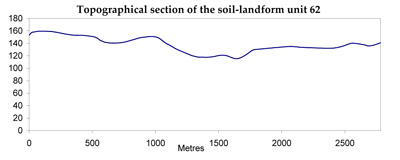
| TOPOGRAPHY Landscape | Elevated longitudinal coastal dunes at and to the west of Cape Otway | |||||
| Elevation range (m) | 0-155 | |||||
| Local relief (m) | 15 | |||||
| Drainage pattern | Mainly absent; some dendritic areas | |||||
| Drainage density (km/km2) | 0.7 | |||||
| Landform | Foredunes | Cliffs | Longitudinal dunes | Interdune corridors | Inland dunes | |
| Landform element | Windward slopes | Leewrd slopes | - | |||
| Slope and range (%) | 20 (15-40) | 65 (50-100) | 25 (5-50) | 20 (5-50) | 3 (0-9) | 25 (3-60) |
| Slope shape | Convex | Linear | Convex | Convex | Concave | Concave |
| NATIVE VEGETATION Structure | Tussock grassland | Open scrub | Open scrub | Woodland | Open forest | Woodland |
| Dominant species | Spinifex hirsutus, Scirpus nodosus, Calocephalus brownii | Casuarine stricta, Cassinia longifolia, Alyxia buxifolia | Alyxia buxifolia, Leucopogon parviflorus, Cassinia longifolia, Acacia verticillata, Leptospermum juniperinum, Helichrysum paraluon | Casuarine stricta, E. viminalis, Leucopogon parviflorus | E. obliqua, E. viminalis | E. viminalis |
| SOIL Parent material | Coarse sand, shell grit | Calcarenite, aeolian sand | Sand with calcarenite basement | Sand with calcarenite basement | Sand with calcarenite basement | Sand with calcarenite basement |
| Description (Corangamite Soil Group) | ||||||
| Soil type sites | ||||||
| Surface texture | Coarse sand | Coarse sand | Loamy sand | Loamy sand | Loamy sand | Loamy sand |
| Permeability | Very high | Very high | Very high | Very high | Very high | Very high |
| Depth (m) | >2 | 0.3 | >2 | >2 | >2 | 1.9 |
| LAND CHARACTERISTICS, POTENTIAL AND LIMITATIONS | Dunes inherently unstable due to cyclical marine erosion. Low fertility, low water holding capacity and vegetation sensitive to disturbance lead to wind erosion and leaching of nutrients | Weakly structured sand soils of low water holding capacity on steep slopes with vegetation sensitive to disturbance and salt pruning are pone to sheet erosion by wind and water. | Weakly structured soils with low water holding capacities, subjected to strong on-shore winds are prone to wind erosion. Low inherent fertility, high alkalinity and rapid leaching lead to nutrient decline. | Weakly structured sand soils with low water holding capacities are prone to wind erosion. Low inherent fertility, high alkalinity and rapid leaching lead to nutrient decline. | Low inherent fertility and high permeability lead to nutrient decline. | Weakly structured sand soils with low water holding capacities are prone to wind erosion. Low inherent fertility and high permeability lead to nutrient decline. |